Trail Walking Thann - Marche du Floridor - Photo

Marche du Floridor

© OpenStreetMap contributors
Length
Length
7.7 km
Max alt
Max alt
560 m
Uphill gradient
Uphill gradient
335 m
Km-Effort
Km-Effort  
12.2 km
Min alt
Min alt
351 m
Downhill gradient
Downhill gradient
338 m
Boucle
Boucle
Yes
Creation date :
2018-10-13 05:53:59.638
Updated on :
2018-10-13 05:53:59.647

(0 Reviews)

Walking
Walking
--
Difficulty : Medium

Scan this QR Code to open this trail in the SityTrail application

FREE GPS app for hiking

Logo SityTrail SityTrail

IGN / Geographical institutes

Download SityTrail from the App Store Download SityTrail from Google Play

Logo SityTrail SityTrail World

The world is yours!

Download SityTrail from the App Store Download SityTrail from Google Play Download SityTrail on Huawei AppGallery

About

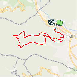
Trail Walking of 7.7 km to be discovered at Grand Est, Haut-Rhin, Thann. This trail is proposed by patrickbeyrath.

Description

Départ à Thann au bout de la rue HUMBERGER près de l'ancien cimetière Israélite-croix de Lorraine-Place Stauffen-Place du Roi de Rome-prendre à gauche Chemein de Steinby et ensuite longer le ruisseau par la droite direction WEIHELE jusqu'au FLORIDOR et retour au point de départ

Elevation profile

Positioning

Country:
France
Region :
Grand Est
Department/Province :
Haut-Rhin
Municipality :
Thann
Location:
Unknown
Start:(UTM)
357250 ; 5297204 (32T) N.

Trails nearby

Trail Other activity Steinbach - lac du ballon - Photo
Other activity
rodabruna

Other activity

Very easy
(1)
Steinbach, Grand Est, Haut-Rhin, France
33 km | 64 km-effort
5h 1min
No
Trail Walking Bourbach-le-Haut - 2024-01-12_14h17m14_239006910 - Photo
Walking
GUIDE
mumu.larandonneuse

Walking

Difficult
Bourbach-le-Haut, Grand Est, Haut-Rhin, France
11.4 km | 18.5 km-effort
4h 12min
Yes
Trail Walking Thann - SityTrail - 2489713 - thann-roche--albert--grumbachkopf - Photo
Walking
argonneuweg

Walking

Medium
(1)
Thann, Grand Est, Haut-Rhin, France
7.6 km | 12 km-effort
2h 28min
Yes
Trail On foot Bitschwiller-lès-Thann - Bitschwiller les Thann - Rehbrunnel - Abri du Becherkopf - Roche Albert - Photo
On foot
patrickbeyrath

On foot

Medium
(1)
Bitschwiller-lès-Thann, Grand Est, Haut-Rhin, France
10.3 km | 16.4 km-effort
Unknown
Yes
Trail Walking Bitschwiller-lès-Thann - 68 Col du Hundsrück  - FA Gsang - retour ThannerHubel - Photo
Walking

Walking

Medium
(1)
Bitschwiller-lès-Thann, Grand Est, Haut-Rhin, France
11.2 km | 18.4 km-effort
3h 48min
Yes
Trail Walking Steinbach - Rando CLAS du 02/11/2023 - Photo
Walking
boubou68

Walking

Very difficult
Steinbach, Grand Est, Haut-Rhin, France
17.7 km | 27 km-effort
4h 35min
Yes
Trail Walking Steinbach - Rando Marcheurs du 03/07/2023 par ALAIN - Photo
Walking
boubou68

Walking

Very difficult
Steinbach, Grand Est, Haut-Rhin, France
20 km | 34 km-effort
5h 1min
Yes
Trail Walking Willer-sur-Thur - Willer sur Thur col du Haag  - Photo
Walking
gamille67

Walking

Medium
Willer-sur-Thur, Grand Est, Haut-Rhin, France
29 km | 46 km-effort
6h 45min
Yes
Trail Walking Bitschwiller-lès-Thann - JD 16/20 Willer sur Thur - Ferme Auberge d'Ostein 15km 4h - Photo
Walking
argonneuweg

Walking

Difficult
Bitschwiller-lès-Thann, Grand Est, Haut-Rhin, France
15.1 km | 22 km-effort
4h 7min
Yes


Close
My subscriptions