Trail Snowshoes Gemeinde Steeg - Autriche - Prenten - LärchspitzGipfel - Photo

Autriche - Prenten - LärchspitzGipfel

© OpenStreetMap contributors
Length
Length
4.6 km
Max alt
Max alt
2118 m
Uphill gradient
Uphill gradient
900 m
Km-Effort
Km-Effort  
13.6 km
Min alt
Min alt
1208 m
Downhill gradient
Downhill gradient
4 m
Boucle
Boucle
No
Creation date :
2014-12-10 00:00:00.0
Updated on :
2014-12-10 00:00:00.0

(0 Reviews)

Snowshoes
Snowshoes
3h00
Difficulty : Medium

Scan this QR Code to open this trail in the SityTrail application

FREE GPS app for hiking

Logo SityTrail SityTrail

IGN / Geographical institutes

Download SityTrail from the App Store Download SityTrail from Google Play

Logo SityTrail SityTrail World

The world is yours!

Download SityTrail from the App Store Download SityTrail from Google Play Download SityTrail on Huawei AppGallery

About

Trail Snowshoes of 4.6 km to be discovered at Tyrol, Bezirk Reutte, Gemeinde Steeg. This trail is proposed by michel.heusschen@skynet.be.

Description

Rando à ski.
Très sympa lorsque bien enneigé. Montée (et descente) à travers bois par toujours facile lorsque sans traces. Quelques passages raides dans les bois.
3h pour la montée.
1h30 pour la descente.

Elevation profile

Positioning

Country:
Austria
Region :
Tyrol
Department/Province :
Bezirk Reutte
Municipality :
Gemeinde Steeg
Location:
Unknown
Start:(UTM)
595182 ; 5233425 (32T) N.

Trails nearby

Trail Walking Gemeinde Steeg - A finir - Photo
Walking
dboon

Walking

Difficult
Gemeinde Steeg, Tyrol, Bezirk Reutte, Austria
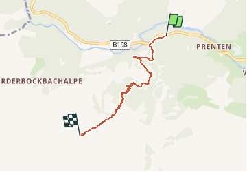
10.9 km | 18.3 km-effort
5h 18min
Yes
Trail Walking Gemeinde Kaisers - Retour  - Photo
Walking
Michel GUISSE

Walking

Easy
Gemeinde Kaisers, Tyrol, Bezirk Reutte, Austria
4.3 km | 5.9 km-effort
1h 16min
No
Trail Walking Gemeinde Steeg - bergfextour_warth--gehrner-berg--schrofenpass--gehren - Photo
Walking
dboon

Walking

Difficult
Gemeinde Steeg, Tyrol, Bezirk Reutte, Austria
7.2 km | 13.8 km-effort
3h 8min
Yes
Trail Walking Gemeinde Steeg - Ring from the
Walking
dboon

Walking

Medium
Gemeinde Steeg, Tyrol, Bezirk Reutte, Austria
6.3 km | 9.3 km-effort
2h 6min
Yes
Trail Walking Gemeinde Steeg - Street - Photo
Walking
FPFSB

Walking

Medium
Gemeinde Steeg, Tyrol, Bezirk Reutte, Austria
6.2 km | 10.2 km-effort
2h 48min
Yes


Close
My subscriptions