Randonnée Course à pied Castelnau-d'Estrétefonds - A l'Estretefonds de mon Castelnau - Photo

A l'Estretefonds de mon Castelnau

 tracegps
tracegps

Utilisateur

© OpenStreetMap contributors
Longueur
Longueur
15,6 km
Altitude max
Altitude max
222 m
Dénivelé positif
Dénivelé positif
233 m
Km-Effort
Km-Effort  
18,7 km
Altitude min
Altitude min
118 m
Dénivelé négatif
Dénivelé négatif
232 m
Boucle
Boucle
Oui
Date de création :
2014-12-10 00:00:00.0
Dernière modification :
2014-12-10 00:00:00.0

(1 Avis)

Course à pied
Course à pied
1h30
Difficulté : Moyen

Scannez ce code QR pour ouvrir la randonnée dans l'application SityTrail

Application GPS de randonnée GRATUITE

Logo SityTrail SityTrail

IGN / Instituts géographiques

Télécharger SityTrail sur l'App Store Télécharger SityTrail sur Google Play

Logo SityTrail SityTrail World

Le monde est à vous

Télécharger SityTrail sur l'App Store Télécharger SityTrail sur Google Play Télécharger SityTrail sur Huawei AppGallery

À propos

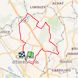
Randonnée Course à pied de 15,6 km à découvrir à Occitanie, Haute-Garonne, Castelnau-d'Estrétefonds. Cette randonnée est proposée par tracegps.

Profil altimétrique

Photos

Localisation

Pays :
France
Région :
Occitanie
Département/Province :
Haute-Garonne
Commune :
Castelnau-d'Estrétefonds
Localité :
Unknown
Départ:(Dec)
Départ:(UTM)
368050 ; 4848872 (31T) N.

Commentaires

Veuillez vous connecter pour laisser un commentaire ou une note


Randonnées à proximité

Randonnée V.T.T. Bouloc - Randonnée VTT entre vignes et bois de Bouloc à Fronton - Photo
V.T.T.
tracegps

V.T.T.

Moyen
Bouloc, Occitanie, Haute-Garonne, France
22 km | 25 km-effort
2h 0min
Oui
Randonnée Course à pied Bouloc - Randonnée de Bouloc à Castelnau d'Estretefonds - Photo
Course à pied
tracegps

Course à pied

Difficile
Bouloc, Occitanie, Haute-Garonne, France
19,9 km | 23 km-effort
2h 0min
Oui
Randonnée V.T.T. Pompignan - VTT Pompignan 2022 - Photo
V.T.T.
PhilB24

V.T.T.

Moyen
Pompignan, Occitanie, Tarn-et-Garonne, France
24 km | 28 km-effort
1h 54min
Oui
Randonnée Marche Ondes - Boucle de Ondes - Photo
Marche
Fafou64

Marche

Facile
(1)
Ondes, Occitanie, Haute-Garonne, France
10,2 km | 10,9 km-effort
2h 27min
Oui
Randonnée A pied Bouloc - Rando 31 de Bouloc à Castelnau  - Photo
A pied
PESCADOU31

A pied

Très facile
Bouloc, Occitanie, Haute-Garonne, France
19,9 km | 23 km-effort
5h 0min
Oui
Randonnée V.T.T. Bouloc - Dénivelé fort castelnau - Photo
V.T.T.
jpferrage

V.T.T.

Bouloc, Occitanie, Haute-Garonne, France
21 km | 26 km-effort
2h 3min
Non
Randonnée Marche Castelnau-d'Estrétefonds - 31_Saint Rustice - Photo
Marche
jab31

Marche

Facile
Castelnau-d'Estrétefonds, Occitanie, Haute-Garonne, France
10,5 km | 12,4 km-effort
2h 32min
Oui
Randonnée Marche Castelnau-d'Estrétefonds - 31_Castelnau d'Estretefonds - Photo
Marche
jab31

Marche

Facile
Castelnau-d'Estrétefonds, Occitanie, Haute-Garonne, France
8,5 km | 10,8 km-effort
1h 46min
Oui
Randonnée V.T.T. Bouloc - Boucle VTT familiale à Bouloc - Photo
V.T.T.
tracegps

V.T.T.

Moyen
Bouloc, Occitanie, Haute-Garonne, France
26 km | 29 km-effort
2h 0min
Oui


Fermer
Mes abonnements