Randonnée Marche Saint-Aventin - Pic de Céciré - Photo
 tracegps
tracegps

Utilisateur

© OpenStreetMap contributors
Longueur
Longueur
5,7 km
Altitude max
Altitude max
2384 m
Dénivelé positif
Dénivelé positif
628 m
Km-Effort
Km-Effort  
12 km
Altitude min
Altitude min
1775 m
Dénivelé négatif
Dénivelé négatif
31 m
Boucle
Boucle
Non
Date de création :
2014-12-10 00:00:00.0
Dernière modification :
2014-12-10 00:00:00.0

(2 Avis)

Marche
Marche
1h30
Difficulté : Difficile

Scannez ce code QR pour ouvrir la randonnée dans l'application SityTrail

Application GPS de randonnée GRATUITE

Logo SityTrail SityTrail

IGN / Instituts géographiques

Télécharger SityTrail sur l'App Store Télécharger SityTrail sur Google Play

Logo SityTrail SityTrail World

Le monde est à vous

Télécharger SityTrail sur l'App Store Télécharger SityTrail sur Google Play Télécharger SityTrail sur Huawei AppGallery

À propos

Randonnée Marche de 5,7 km à découvrir à Occitanie, Haute-Garonne, Saint-Aventin. Cette randonnée est proposée par tracegps.

Description

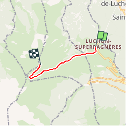
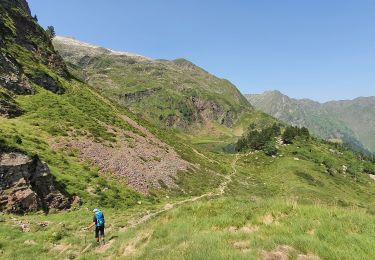
Un joli Pic à faire en partant de Superbagnères (1800m), station siuée au dessus de Bagnères de Luchon. On y monte par la télécabine ouverte de Juillet à Septembre, ou par la route. On part du parking de la station en empruntant le GR®10 en direction du sud pour attraper la petite crête que l’on suit vers l’ouest. On quitte le GR®10 vers 2250m pour prendre à droite la pente qui nous mène vers le sommet. Beau point de vue sur le Luchonnais.

Profil altimétrique

Photos

Localisation

Pays :
France
Région :
Occitanie
Département/Province :
Haute-Garonne
Commune :
Saint-Aventin
Localité :
Unknown
Départ:(Dec)
Départ:(UTM)
301686 ; 4737740 (31T) N.

Commentaires

Veuillez vous connecter pour laisser un commentaire ou une note


Attention le gr est modifiée depuis le parking accès au col très long chemin sans intérêt prévoir parking col 2h donc rando sans plaisir


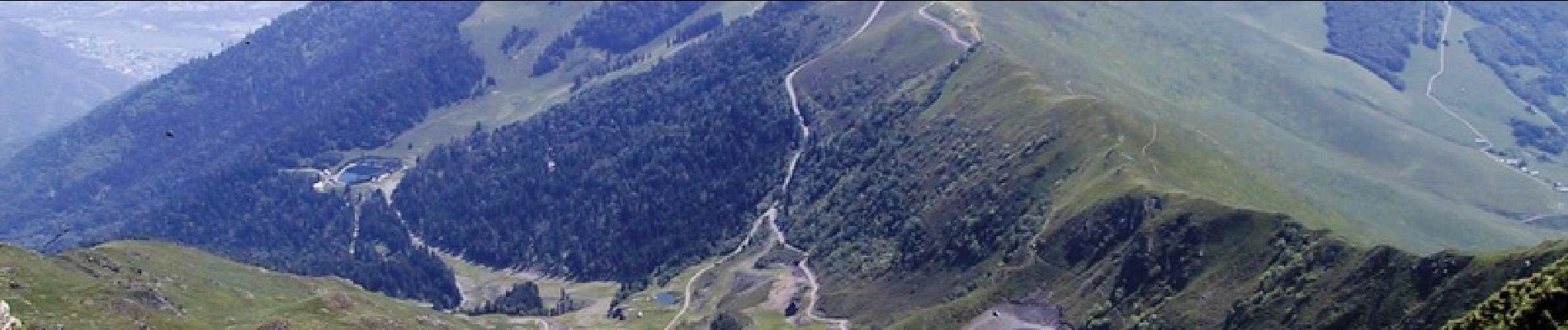
superbe paysage sur le domaine


Randonnées à proximité

Randonnée Raquettes à neige Juzet-de-Luchon - JUZET - PAS DE LA COMBE (LABACH) - Photo
Raquettes à neige
Marcocroco

Raquettes à neige

Moyen
(1)
Juzet-de-Luchon, Occitanie, Haute-Garonne, France
7,1 km | 12,5 km-effort
2h 33min
Oui
Randonnée Marche Saint-Mamet - Fonds de Burbe - Saint Mamet - Photo
Marche
tracegps

Marche

Difficile
(1)
Saint-Mamet, Occitanie, Haute-Garonne, France
15,6 km | 27 km-effort
4h 0min
Oui
Randonnée V.T.T. Saint-Aventin - Luchon Kbour - Photo
V.T.T.
tracegps

V.T.T.

Très difficile
(1)
Saint-Aventin, Occitanie, Haute-Garonne, France
11 km | 16,7 km-effort
1h 0min
Non
Randonnée A pied Castillon-de-Larboust - Lac Vert, Boucle par l'Est - Photo
A pied
PRO

A pied

Facile
Castillon-de-Larboust, Occitanie, Haute-Garonne, France
8,8 km | 19,5 km-effort
4h 26min
Non
Randonnée Marche Bagnères-de-Luchon - GR 10 - 3 - Photo
Marche
loic09

Marche

Moyen
(2)
Bagnères-de-Luchon, Occitanie, Haute-Garonne, France
250 km | 489 km-effort
89h 8min
Non
Randonnée Marche Saint-Aventin - Cabane de Courreau en boucle depuis St Aventin  - Photo
Marche
GUIDE
lhomme.ph

Marche

Moyen
Saint-Aventin, Occitanie, Haute-Garonne, France
13,3 km | 24 km-effort
6h 10min
Oui
Randonnée Marche Castillon-de-Larboust - Cabane de la Coume - Photo
Marche
swp648

Marche

Difficile
Castillon-de-Larboust, Occitanie, Haute-Garonne, France
9,1 km | 18,4 km-effort
3h 39min
Oui
Randonnée Marche Bagnères-de-Luchon - 2022 08 -Transpyrénéen 2 : Bagnères de Luchon -Fos - Photo
Marche
LEGUE

Marche

Très difficile
Bagnères-de-Luchon, Occitanie, Haute-Garonne, France
30 km | 55 km-effort
7h 8min
Non
Randonnée Marche Castillon-de-Larboust - lacs vert et bleu en boucle - Photo
Marche
chrisgps

Marche

Difficile
Castillon-de-Larboust, Occitanie, Haute-Garonne, France
15,2 km | 32 km-effort
9h 17min
Oui


Fermer
Mes abonnements