Randonnée V.T.T. Cahors - Cahors-La Rozière 2005 - Photo

Cahors-La Rozière 2005

 tracegps
tracegps

Utilisateur

© OpenStreetMap contributors
Longueur
Longueur
62 km
Altitude max
Altitude max
337 m
Dénivelé positif
Dénivelé positif
1434 m
Km-Effort
Km-Effort  
81 km
Altitude min
Altitude min
93 m
Dénivelé négatif
Dénivelé négatif
1435 m
Boucle
Boucle
Oui
Date de création :
2014-12-10 00:00:00.0
Dernière modification :
2014-12-10 00:00:00.0

(1 Avis)

V.T.T.
V.T.T.
5h00
Difficulté : Très difficile

Scannez ce code QR pour ouvrir la randonnée dans l'application SityTrail

Application GPS de randonnée GRATUITE

Logo SityTrail SityTrail

IGN / Instituts géographiques

Télécharger SityTrail sur l'App Store Télécharger SityTrail sur Google Play

Logo SityTrail SityTrail World

Le monde est à vous

Télécharger SityTrail sur l'App Store Télécharger SityTrail sur Google Play Télécharger SityTrail sur Huawei AppGallery

À propos

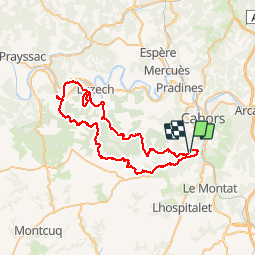
Randonnée V.T.T. de 62 km à découvrir à Occitanie, Lot, Cahors. Cette randonnée est proposée par tracegps.

Description

14 Mai 2005 Je vous mets quelques commentaires en vrac piqués sur le forum de VV : XIII a dit : "Déja super beau temps et 380 participants ... quand on aime , on revient, ca se confirme pour cette 2nde manche de la RCO. Les organisateurs ravis bien sur et c'est merite car ils etaient nombreux et motives ... bref, y avait de l'ENVIE.... La suite est ICI

Profil altimétrique

Photos

Localisation

Pays :
France
Région :
Occitanie
Département/Province :
Lot
Commune :
Cahors
Localité :
Unknown
Départ:(Dec)
Départ:(UTM)
374088 ; 4919239 (31T) N.

Commentaires

Veuillez vous connecter pour laisser un commentaire ou une note


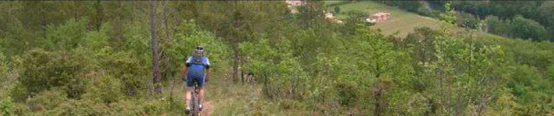
parcours fabuleux avec variété de chemins et singles.Superbes paysages. Mais il faut se le gagner!!!


Randonnées à proximité

Randonnée Marche Pradines - Cahors les Durands 7km - Photo
Marche
PariseJL

Marche

Facile
(1)
Pradines, Occitanie, Lot, France
7,1 km | 9,3 km-effort
2h 13min
Oui
Randonnée Marche Cahors - Croix magne  - Photo
Marche
GUIDE
antignacs

Marche

Très facile
Cahors, Occitanie, Lot, France
5,2 km | 7,2 km-effort
1h 20min
Non
Randonnée Marche Cahors - Étape Cahors Lascabannes  - Photo
Marche
Jean-MarieFaux

Marche

Facile
Cahors, Occitanie, Lot, France
23 km | 30 km-effort
18h 50min
Non
Randonnée Marche Cahors - CC_Velay_DC_15_Cahors_Lendou-En-Quercy_20080506 - Photo
Marche
patrickdanilo

Marche

Moyen
Cahors, Occitanie, Lot, France
22 km | 29 km-effort
4h 40min
Non
Randonnée Marche Labastide-Marnhac - Mon Compostelle huitième étape - Photo
Marche
Ardeiserois

Marche

Difficile
Labastide-Marnhac, Occitanie, Lot, France
51 km | 65 km-effort
10h 40min
Non
Randonnée V.T.T. Trespoux-Rassiels - Circuit ouest de Trespoux Rassiels - Photo
V.T.T.
tracegps

V.T.T.

Très difficile
Trespoux-Rassiels, Occitanie, Lot, France
38 km | 51 km-effort
4h 15min
Oui
Randonnée Marche Cahors - Cahors - Lascabanes - Chemin de Compostelle - Photo
Marche
tracegps

Marche

Très difficile
(1)
Cahors, Occitanie, Lot, France
24 km | 31 km-effort
9h 30min
Non
Randonnée Course à pied Cahors - Cahors, le Lot, le causse, la vieille ville - Photo
Course à pied
tracegps

Course à pied

Moyen
Cahors, Occitanie, Lot, France
7,3 km | 10 km-effort
45min
Oui
Randonnée Marche Cahors - Cahors, le Lot, le causse, la vieille ville - Photo
Marche
tracegps

Marche

Moyen
Cahors, Occitanie, Lot, France
7,3 km | 10 km-effort
1h 30min
Oui


Fermer
Mes abonnements