Randonnée Marche Guebwiller - Les Contours de Peternit près de Guebwiller - Photo

Les Contours de Peternit près de Guebwiller

 tracegps
tracegps

Utilisateur

© OpenStreetMap contributors
Longueur
Longueur
10,6 km
Altitude max
Altitude max
637 m
Dénivelé positif
Dénivelé positif
380 m
Km-Effort
Km-Effort  
15,6 km
Altitude min
Altitude min
453 m
Dénivelé négatif
Dénivelé négatif
374 m
Boucle
Boucle
Oui
Date de création :
2014-12-10 00:00:00.0
Dernière modification :
2014-12-10 00:00:00.0

(0 Avis)

Marche
Marche
1h30
Difficulté : Difficile

Scannez ce code QR pour ouvrir la randonnée dans l'application SityTrail

Application GPS de randonnée GRATUITE

Logo SityTrail SityTrail

IGN / Instituts géographiques

Télécharger SityTrail sur l'App Store Télécharger SityTrail sur Google Play

Logo SityTrail SityTrail World

Le monde est à vous

Télécharger SityTrail sur l'App Store Télécharger SityTrail sur Google Play Télécharger SityTrail sur Huawei AppGallery

À propos

Randonnée Marche de 10,6 km à découvrir à Grand Est, Haut-Rhin, Guebwiller. Cette randonnée est proposée par tracegps.

Description

Toutes les descriptions sont ICI

Profil altimétrique

Photos

Localisation

Pays :
France
Région :
Grand Est
Département/Province :
Haut-Rhin
Commune :
Guebwiller
Localité :
Unknown
Départ:(Dec)
Départ:(UTM)
364892 ; 5306733 (32T) N.

Randonnées à proximité

Randonnée Marche Soultz-Haut-Rhin - Hartmannswillerkopf - Circuit découverte - Photo
Marche
VacheKiri67

Marche

Facile
(1)
Soultz-Haut-Rhin, Grand Est, Haut-Rhin, France
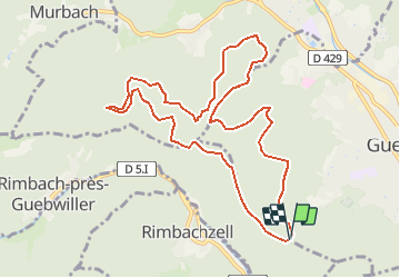
3,6 km | 5,2 km-effort
1h 46min
Oui
Randonnée Marche Soultz-Haut-Rhin - Hartmannswillerkopf - Circuit anneau bleu - Photo
Marche
VacheKiri67

Marche

Moyen
(1)
Soultz-Haut-Rhin, Grand Est, Haut-Rhin, France
3,7 km | 5,9 km-effort
1h 37min
Oui
Randonnée A pied Goldbach-Altenbach - Firstacker - Willer sur Thur - Photo
A pied
PRO

A pied

Facile
Goldbach-Altenbach, Grand Est, Haut-Rhin, France
7,4 km | 9,6 km-effort
2h 11min
Non
Randonnée Trail Wattwiller - The History Ultra - Stage 1 - Photo
Trail
Olivier Houette

Trail

Très facile
(1)
Wattwiller, Grand Est, Haut-Rhin, France
28 km | 48 km-effort
Inconnu
Non
Randonnée Marche Soultz-Haut-Rhin - Rando Marcheurs..04/04_2025 - Photo
Marche
boubou68

Marche

Très difficile
Soultz-Haut-Rhin, Grand Est, Haut-Rhin, France
21 km | 35 km-effort
4h 42min
Oui
Randonnée Marche Jungholtz - Rando Retrouvailles...01/03/2024.par Jean Marc - Photo
Marche
boubou68

Marche

Très difficile
Jungholtz, Grand Est, Haut-Rhin, France
11,3 km | 19,2 km-effort
1h 35min
Oui
Randonnée Marche Murbach - La
Marche
boubou68

Marche

Très difficile
Murbach, Grand Est, Haut-Rhin, France
14,7 km | 28 km-effort
4h 3min
Oui
Randonnée Marche Murbach - Murbach - Photo
Marche
oscar1

Marche

Difficile
Murbach, Grand Est, Haut-Rhin, France
15,4 km | 25 km-effort
4h 25min
Oui
Randonnée Marche Soultz-Haut-Rhin - Rando avec 0mar et Mouloud..18/02/2023 - Photo
Marche
boubou68

Marche

Très difficile
Soultz-Haut-Rhin, Grand Est, Haut-Rhin, France
12 km | 20 km-effort
3h 9min
Oui


Fermer
Mes abonnements