Randonnée Marche Linthal - 68 Remspach - FA Hilsen  - Photo

68 Remspach - FA Hilsen

 E.BURCK
E.BURCK

Utilisateur

© OpenStreetMap contributors
Longueur
Longueur
6,7 km
Altitude max
Altitude max
1075 m
Dénivelé positif
Dénivelé positif
244 m
Km-Effort
Km-Effort  
9,9 km
Altitude min
Altitude min
835 m
Dénivelé négatif
Dénivelé négatif
246 m
Boucle
Boucle
Oui
Date de création :
2019-05-22 16:12:02.642
Dernière modification :
2019-12-17 13:28:13.889

(0 Avis)

Marche
Marche
2h04
Difficulté : Moyen

Scannez ce code QR pour ouvrir la randonnée dans l'application SityTrail

Application GPS de randonnée GRATUITE

Logo SityTrail SityTrail

IGN / Instituts géographiques

Télécharger SityTrail sur l'App Store Télécharger SityTrail sur Google Play

Logo SityTrail SityTrail World

Le monde est à vous

Télécharger SityTrail sur l'App Store Télécharger SityTrail sur Google Play Télécharger SityTrail sur Huawei AppGallery

À propos

Randonnée Marche de 6,7 km à découvrir à Grand Est, Haut-Rhin, Linthal. Cette randonnée est proposée par E.BURCK.

Description

Retour rapide, dénivelé est de 380 m sur 10.5 km                                                                            ACCÈS :            
- Guebwiller, Lautenbach, Linthal ,
-à Linthal, au monument, prendre à droite, puis 300 m plus loin à gauche direction Remspach,            
- ensuite avant l'entrée de Remspach, prendre l'épingle à droite qui va vers la colonie de vacances PTT.            
PARKING :            
- après le virage à gauche, laisser le chemin qui va vers la colonie de vacances à votre gauche et continuer tout droit.            
- Puis à 200 m, il y a sur la gauche du chemin un emplacement pour se garer.            
47.9534,        7.1069  ou  
N 47°57'12", E 07°06'25"            
Attention, dans  un premier temps, dans Linthal il vaut mieux suivre mes indications et le plan ci-joint; le GPS risque de vous faire faire un détour.                                  
RESTAURATION :                          
Ferme Auberge du Hilsen.    
Tél: 03 89 74 03 15

Profil altimétrique

Localisation

Pays :
France
Région :
Grand Est
Département/Province :
Haut-Rhin
Commune :
Linthal
Localité :
Unknown
Départ:(Dec)
Départ:(UTM)
358655 ; 5312852 (32T) N.

Randonnées à proximité

Randonnée Marche Lautenbach - Tour du Petit Ballon - Photo
Marche
VacheKiri67

Marche

Moyen
(1)
Lautenbach, Grand Est, Haut-Rhin, France
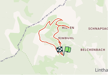
12,7 km | 20 km-effort
4h 46min
Oui
Randonnée Marche Linthal - Markstein - Photo
Marche
VacheKiri67

Marche

Moyen
(1)
Linthal, Grand Est, Haut-Rhin, France
14 km | 19,8 km-effort
4h 45min
Oui
Randonnée Marche Linthal - Tour de la grande Vallée de Munster (refuge du Hilsen - Munster) - Photo
Marche
tracegps

Marche

Difficile
(1)
Linthal, Grand Est, Haut-Rhin, France
18,1 km | 24 km-effort
5h 0min
Non
Randonnée Marche Lautenbachzell - Le Markstein - Photo
Marche
tracegps

Marche

Difficile
(1)
Lautenbachzell, Grand Est, Haut-Rhin, France
22 km | 35 km-effort
6h 0min
Oui
Randonnée Marche Sondernach - 2023-05-19 WE Marche Bivouac Massif du Hohneck - Photo
Marche
GUIDE
holtzv

Marche

Moyen
Sondernach, Grand Est, Haut-Rhin, France
46 km | 73 km-effort
16h 41min
Oui
Randonnée Marche Sondernach - 2023-05-19 Marche Schnepfenried vers Lac du Fischboedle - Photo
Marche
GUIDE
holtzv

Marche

Facile
Sondernach, Grand Est, Haut-Rhin, France
9,1 km | 14,1 km-effort
3h 12min
Non
Randonnée Marche Linthal - 68 Remspach - Hilsen - Photo
Marche

Marche

Moyen
(1)
Linthal, Grand Est, Haut-Rhin, France
9,9 km | 14,6 km-effort
3h 3min
Oui
Randonnée A pied Wasserbourg - Boenlesgrab - Drei Schöpf - Bannwald - Chalet St Hubert - Brunnemaëttlé - Wassmatt - Hansen et retour - Photo
A pied
patrickbeyrath

A pied

Moyen
(1)
Wasserbourg, Grand Est, Haut-Rhin, France
10,2 km | 14,2 km-effort
Inconnu
Oui
Randonnée Marche Wasserbourg - 68 Boenlesgrab - FA du Strohberg - Photo
Marche

Marche

Difficile
(1)
Wasserbourg, Grand Est, Haut-Rhin, France
9,6 km | 15,1 km-effort
3h 0min
Oui


Fermer
Mes abonnements