Randonnée V.T.T. Barbery - VTT autour de Barbery - Photo

VTT autour de Barbery

 tracegps
tracegps

Utilisateur

© OpenStreetMap contributors
Longueur
Longueur
40 km
Altitude max
Altitude max
290 m
Dénivelé positif
Dénivelé positif
528 m
Km-Effort
Km-Effort  
47 km
Altitude min
Altitude min
131 m
Dénivelé négatif
Dénivelé négatif
528 m
Boucle
Boucle
Oui
Date de création :
2014-12-10 00:00:00.0
Dernière modification :
2014-12-10 00:00:00.0

(0 Avis)

V.T.T.
V.T.T.
2h30
Difficulté : Moyen

Scannez ce code QR pour ouvrir la randonnée dans l'application SityTrail

Application GPS de randonnée GRATUITE

Logo SityTrail SityTrail

IGN / Instituts géographiques

Télécharger SityTrail sur l'App Store Télécharger SityTrail sur Google Play

Logo SityTrail SityTrail World

Le monde est à vous

Télécharger SityTrail sur l'App Store Télécharger SityTrail sur Google Play Télécharger SityTrail sur Huawei AppGallery

À propos

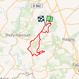
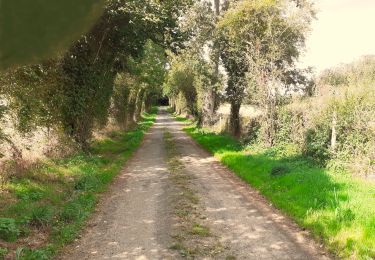
Randonnée V.T.T. de 40 km à découvrir à Normandie, Calvados, Barbery. Cette randonnée est proposée par tracegps.

Description

Départ de la mairie de Barbery. Le circuit est relativement facile avec des chemins très roulants. Certains passages sont assez techniques: ornières, pierriers... Bonne promenade.

Profil altimétrique

Photos

Localisation

Pays :
France
Région :
Normandie
Département/Province :
Calvados
Commune :
Barbery
Localité :
Unknown
Départ:(Dec)
Départ:(UTM)
693745 ; 5431979 (30U) N.

Randonnées à proximité

Randonnée Geocaching Barbery - GC745R5 = https://coord.info/GC745R5 - Photo
Geocaching
yannick-p

Geocaching

Facile
Barbery, Normandie, Calvados, France
6,5 km | 7,5 km-effort
2h 40min
Oui
Randonnée Marche Barbery - Babery Annick - Photo
Marche
gr1346

Marche

Moyen
Barbery, Normandie, Calvados, France
9 km | 10,1 km-effort
2h 34min
Oui
Randonnée A pied Bretteville-sur-Laize - Bretteville sur Laize / Urville - Photo
A pied
Privatb

A pied

Facile
(1)
Bretteville-sur-Laize, Normandie, Calvados, France
15,3 km | 18 km-effort
4h 5min
Oui
Randonnée Marche Boulon - rando - Photo
Marche
NICOLAS.Monique

Marche

Très facile
Boulon, Normandie, Calvados, France
33 km | 37 km-effort
14min
Non
Randonnée Marche Boulon - boulon-99 - Photo
Marche
gr1346

Marche

Très facile
Boulon, Normandie, Calvados, France
7,6 km | 8,9 km-effort
2h 20min
Non
Randonnée Marche Gouvix - Gouvix - Photo
Marche
Jeff_314

Marche

Facile
Gouvix, Normandie, Calvados, France
5,7 km | 6,3 km-effort
1h 50min
Oui
Randonnée Marche Urville - Urville et La Laize - Photo
Marche
Jeff_314

Marche

Moyen
Urville, Normandie, Calvados, France
5,1 km | 6,2 km-effort
1h 43min
Oui
Randonnée V.T.T. Cintheaux - Pays du Cinglais - Photo
V.T.T.
tracegps

V.T.T.

Moyen
Cintheaux, Normandie, Calvados, France
38 km | 43 km-effort
2h 15min
Oui
Randonnée Marche Urville - campeaux  repérage  - Photo
Marche
chrisdouville

Marche

Très difficile
Urville, Normandie, Calvados, France
110 km | 131 km-effort
63h 58min
Non


Fermer
Mes abonnements