Randonnée V.T.T. Cloyes-les-Trois-Rivières - Haute vallée du Loir en VTT - Photo
 tracegps
tracegps

Utilisateur

© OpenStreetMap contributors
Longueur
Longueur
82 km
Altitude max
Altitude max
156 m
Dénivelé positif
Dénivelé positif
953 m
Km-Effort
Km-Effort  
94 km
Altitude min
Altitude min
95 m
Dénivelé négatif
Dénivelé négatif
953 m
Boucle
Boucle
Oui
Date de création :
2014-12-10 00:00:00.0
Dernière modification :
2014-12-10 00:00:00.0

(0 Avis)

V.T.T.
V.T.T.
4h10
Difficulté : Difficile

Scannez ce code QR pour ouvrir la randonnée dans l'application SityTrail

Application GPS de randonnée GRATUITE

Logo SityTrail SityTrail

IGN / Instituts géographiques

Télécharger SityTrail sur l'App Store Télécharger SityTrail sur Google Play

Logo SityTrail SityTrail World

Le monde est à vous

Télécharger SityTrail sur l'App Store Télécharger SityTrail sur Google Play Télécharger SityTrail sur Huawei AppGallery

À propos

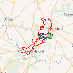
Randonnée V.T.T. de 82 km à découvrir à Centre-Val de Loire, Eure-et-Loir, Cloyes-les-Trois-Rivières. Cette randonnée est proposée par tracegps.

Description

Un peu le même circuit que mon autre parcours (Grand Tour d'Autheuil) mais avec une boucle en plus sur la Chapelle du Noyer. Il faut juste prévoir un peu de temps pour effectuer ce parcours...

Profil altimétrique

Localisation

Pays :
France
Région :
Centre-Val de Loire
Département/Province :
Eure-et-Loir
Commune :
Cloyes-les-Trois-Rivières
Localité :
Autheuil
Départ:(Dec)
Départ:(UTM)
373370 ; 5320450 (31U) N.

Randonnées à proximité

Randonnée Marche Cloyes-les-Trois-Rivières - Moulin rouge - Photo
Marche
mallovon

Marche

Moyen
Cloyes-les-Trois-Rivières, Centre-Val de Loire, Eure-et-Loir, France
6,3 km | 7 km-effort
1h 54min
Oui
Randonnée Marche Cloyes-les-Trois-Rivières - St-Hilaire-sur-Yerre - Photo
Marche
Jean LABADIE

Marche

Moyen
Cloyes-les-Trois-Rivières, Centre-Val de Loire, Eure-et-Loir, France
18,1 km | 21 km-effort
4h 30min
Oui
Randonnée A pied Cloyes-les-Trois-Rivières - Douy PC27sept2020 - Photo
A pied
CRUZILLACP

A pied

Moyen
Cloyes-les-Trois-Rivières, Centre-Val de Loire, Eure-et-Loir, France
11,3 km | 13 km-effort
Inconnu
Oui
Randonnée Marche nordique Châteaudun - Marche_Chateaudun_20140326 - Photo
Marche nordique
chlafaille

Marche nordique

Difficile
Châteaudun, Centre-Val de Loire, Eure-et-Loir, France
21 km | 24 km-effort
3h 42min
Oui
Randonnée V.T.T. Cloyes-les-Trois-Rivières - Rando Cloyes 2009 - Photo
V.T.T.
tracegps

V.T.T.

Difficile
Cloyes-les-Trois-Rivières, Centre-Val de Loire, Eure-et-Loir, France
46 km | 54 km-effort
2h 45min
Oui
Randonnée V.T.T. Cloyes-les-Trois-Rivières - Vers Saint Denis les ponts - Photo
V.T.T.
tracegps

V.T.T.

Moyen
Cloyes-les-Trois-Rivières, Centre-Val de Loire, Eure-et-Loir, France
33 km | 38 km-effort
2h 0min
Oui
Randonnée V.T.T. Cloyes-les-Trois-Rivières - Grand Tour d'Autheuil - Photo
V.T.T.
tracegps

V.T.T.

Difficile
Cloyes-les-Trois-Rivières, Centre-Val de Loire, Eure-et-Loir, France
61 km | 69 km-effort
3h 15min
Oui
Randonnée Marche Cloyes-les-Trois-Rivières - rando de Montigny - Photo
Marche
Jean LABADIE

Marche

Moyen
Cloyes-les-Trois-Rivières, Centre-Val de Loire, Eure-et-Loir, France
18,1 km | 21 km-effort
4h 0min
Oui
Randonnée Marche Cloyes-les-Trois-Rivières - 20231125 ww*wwxx - Photo
Marche
Jeanclaudebic

Marche

Très difficile
Cloyes-les-Trois-Rivières, Centre-Val de Loire, Eure-et-Loir, France
26 km | 29 km-effort
6h 10min
Oui


Fermer
Mes abonnements