Randonnée Marche Montmaurin - Gorges de la Save - Montmaurin - Photo

Gorges de la Save - Montmaurin

 tracegps
tracegps

Utilisateur

© OpenStreetMap contributors
Longueur
Longueur
10,7 km
Altitude max
Altitude max
381 m
Dénivelé positif
Dénivelé positif
222 m
Km-Effort
Km-Effort  
13,7 km
Altitude min
Altitude min
291 m
Dénivelé négatif
Dénivelé négatif
216 m
Boucle
Boucle
Non
Date de création :
2014-12-10 00:00:00.0
Dernière modification :
2014-12-10 00:00:00.0

(2 Avis)

Marche
Marche
2h43
Difficulté : Moyen

Scannez ce code QR pour ouvrir la randonnée dans l'application SityTrail

Application GPS de randonnée GRATUITE

Logo SityTrail SityTrail

IGN / Instituts géographiques

Télécharger SityTrail sur l'App Store Télécharger SityTrail sur Google Play

Logo SityTrail SityTrail World

Le monde est à vous

Télécharger SityTrail sur l'App Store Télécharger SityTrail sur Google Play Télécharger SityTrail sur Huawei AppGallery

À propos

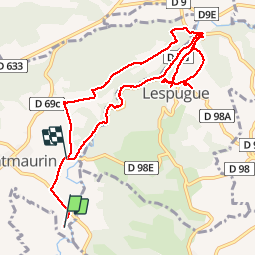
Randonnée Marche de 10,7 km à découvrir à Occitanie, Haute-Garonne, Montmaurin. Cette randonnée est proposée par tracegps.

Description

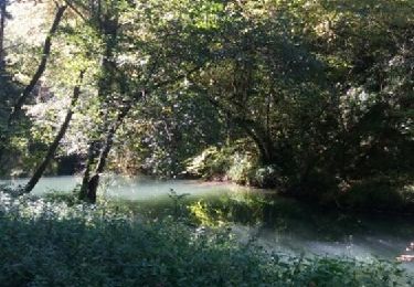
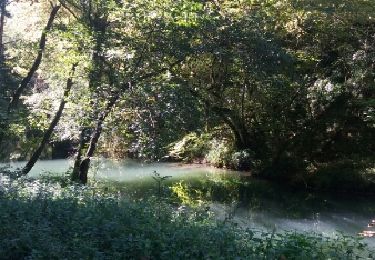
Randonnée agréable et facile. Attention, il peut faire bien froid dans les gorges (environ 3 km).

Profil altimétrique

Photos

Localisation

Pays :
France
Région :
Occitanie
Département/Province :
Haute-Garonne
Commune :
Montmaurin
Localité :
Unknown
Départ:(Dec)
Départ:(UTM)
308777 ; 4787452 (31T) N.

Commentaires

Veuillez vous connecter pour laisser un commentaire ou une note


itinéraire fermé obligé de passer le long de la route. Rien vu des gorges.... 😭


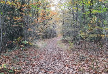
Belle balade, des deux côtés en haut des gorges puis à l'intérieur.


Randonnées à proximité

Randonnée Marche Cardeilhac - Boucle à Cardeilhac - Photo
Marche
tracegps

Marche

Moyen
(1)
Cardeilhac, Occitanie, Haute-Garonne, France
17,5 km | 21 km-effort
4h 30min
Oui
Randonnée Marche Cardeilhac - arboretum de cardeilhac  - Photo
Marche
GUIDE
lhomme.ph

Marche

Très facile
Cardeilhac, Occitanie, Haute-Garonne, France
6,6 km | 7,6 km-effort
1h 46min
Oui
Randonnée Marche Charlas - Charlas: gorges de la Save - Photo
Marche
patricklecetre

Marche

Facile
(1)
Charlas, Occitanie, Haute-Garonne, France
16,7 km | 21 km-effort
4h 33min
Oui
Randonnée Marche Charlas - Charlas: gorges de la Save - Photo
Marche
pidjam

Marche

Facile
Charlas, Occitanie, Haute-Garonne, France
16,7 km | 21 km-effort
4h 33min
Oui
Randonnée Marche Cardeilhac - Arboretum de Cardeilhac - Photo
Marche
GUIDE
lhomme.ph

Marche

Très facile
Cardeilhac, Occitanie, Haute-Garonne, France
6,6 km | 7,6 km-effort
1h 40min
Oui
Randonnée Marche Cardeilhac - arboretum - Photo
Marche
GUIDE
lhomme.ph

Marche

Très facile
Cardeilhac, Occitanie, Haute-Garonne, France
6,6 km | 7,6 km-effort
2h 8min
Oui
Randonnée Marche Cardeilhac - Gorges Save - Photo
Marche
(null) (null)2d73a32012fbb405f85d3457f10971c41

Marche

Facile
Cardeilhac, Occitanie, Haute-Garonne, France
21 km | 0 m-effort
5h 16min
Non
Randonnée Marche Sarremezan - 31_Montmaurin - Photo
Marche
jab31

Marche

Moyen
Sarremezan, Occitanie, Haute-Garonne, France
18,7 km | 24 km-effort
4h 33min
Non
Randonnée Marche Montmaurin - Montmaurin  - Photo
Marche
nanard31

Marche

Très facile
Montmaurin, Occitanie, Haute-Garonne, France
16,6 km | 21 km-effort
5h 8min
Oui


Fermer
Mes abonnements