Randonnée Marche Saint-Léger-Vauban - Tour du Morvan pédestre - de Moulin Simonneau à Chastellux sur Cure - Photo

Tour du Morvan pédestre - de Moulin Simonneau à Chastellux sur Cure

 tracegps
tracegps

Utilisateur

© OpenStreetMap contributors
Longueur
Longueur
17,6 km
Altitude max
Altitude max
434 m
Dénivelé positif
Dénivelé positif
469 m
Km-Effort
Km-Effort  
24 km
Altitude min
Altitude min
268 m
Dénivelé négatif
Dénivelé négatif
479 m
Boucle
Boucle
Non
Date de création :
2014-12-10 00:00:00.0
Dernière modification :
2014-12-10 00:00:00.0

(0 Avis)

Marche
Marche
4h45
Difficulté : Moyen

Scannez ce code QR pour ouvrir la randonnée dans l'application SityTrail

Application GPS de randonnée GRATUITE

Logo SityTrail SityTrail

IGN / Instituts géographiques

Télécharger SityTrail sur l'App Store Télécharger SityTrail sur Google Play

Logo SityTrail SityTrail World

Le monde est à vous

Télécharger SityTrail sur l'App Store Télécharger SityTrail sur Google Play Télécharger SityTrail sur Huawei AppGallery

À propos

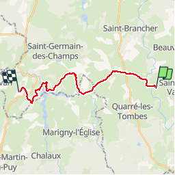
Randonnée Marche de 17,6 km à découvrir à Bourgogne-Franche-Comté, Yonne, Saint-Léger-Vauban. Cette randonnée est proposée par tracegps.

Description

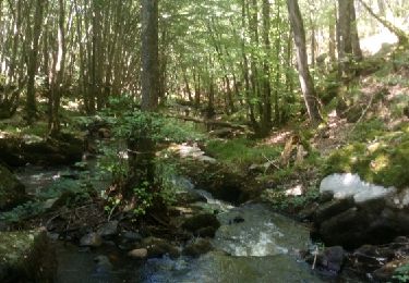
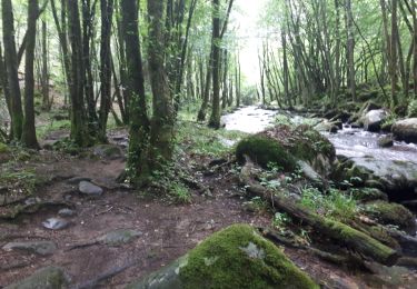
Sans difficultés, la dernière étape nous ramène à Chastellux sur Cure.

Profil altimétrique

Localisation

Pays :
France
Région :
Bourgogne-Franche-Comté
Département/Province :
Yonne
Commune :
Saint-Léger-Vauban
Localité :
Unknown
Départ:(Dec)
Départ:(UTM)
577142 ; 5248431 (31T) N.

Randonnées à proximité

Randonnée Marche Saint-Léger-Vauban - Abbaye-Quarre-Abbaye - Photo
Marche
Yannick89

Marche

Très facile
Saint-Léger-Vauban, Bourgogne-Franche-Comté, Yonne, France
19,2 km | 25 km-effort
5h 12min
Oui
Randonnée Course à pied Saint-Léger-Vauban - la pierre qui vire - Photo
Course à pied
dadodeca

Course à pied

Moyen
Saint-Léger-Vauban, Bourgogne-Franche-Comté, Yonne, France
29 km | 39 km-effort
2h 6min
Non
Randonnée V.T.T. Quarré-les-Tombes - Grande Traversée du Morvan : Quarré les Tombes - Saulieu - Photo
V.T.T.
tracegps

V.T.T.

Difficile
Quarré-les-Tombes, Bourgogne-Franche-Comté, Yonne, France
46 km | 59 km-effort
5h 30min
Non
Randonnée V.T.T. Quarré-les-Tombes - 2 Quarré Saulieu montsauche les Settons 80km 1613m D+ - Photo
V.T.T.
topolino

V.T.T.

Très difficile
Quarré-les-Tombes, Bourgogne-Franche-Comté, Yonne, France
80 km | 101 km-effort
7h 1min
Non
Randonnée A pied Saint-Léger-Vauban - St Léger Vauban 22.86 - Photo
A pied
togolo28

A pied

Moyen
Saint-Léger-Vauban, Bourgogne-Franche-Comté, Yonne, France
23 km | 30 km-effort
Inconnu
Oui
Randonnée A pied Saint-Léger-Vauban - St Léger Vauban 18.32 - Photo
A pied
togolo28

A pied

Moyen
Saint-Léger-Vauban, Bourgogne-Franche-Comté, Yonne, France
18,3 km | 23 km-effort
Inconnu
Oui
Randonnée Cheval Quarré-les-Tombes - Arrivée du chalaux - Photo
Cheval
balmesc

Cheval

Moyen
Quarré-les-Tombes, Bourgogne-Franche-Comté, Yonne, France
24 km | 33 km-effort
4h 53min
Oui
Randonnée V.T.T. Quarré-les-Tombes - crête de quarre - Photo
V.T.T.
oiujkl

V.T.T.

Facile
Quarré-les-Tombes, Bourgogne-Franche-Comté, Yonne, France
16,7 km | 21 km-effort
1h 40min
Oui
Randonnée Autre activité Quarré-les-Tombes - QUARRE LES TOMBES/ ALLIGNY - Photo
Autre activité
DANCHAUD

Autre activité

Très facile
Quarré-les-Tombes, Bourgogne-Franche-Comté, Yonne, France
60 km | 75 km-effort
2h 0min
Non


Fermer
Mes abonnements