Randonnée V.T.T. Le Havre - Le Havre Montgeon - Fontaine - Rouelle - Le Havre Montgeon - Photo

Le Havre Montgeon - Fontaine - Rouelle - Le Havre Montgeon

 tracegps
tracegps

Utilisateur

© OpenStreetMap contributors
Longueur
Longueur
14,2 km
Altitude max
Altitude max
90 m
Dénivelé positif
Dénivelé positif
239 m
Km-Effort
Km-Effort  
17,4 km
Altitude min
Altitude min
14 m
Dénivelé négatif
Dénivelé négatif
241 m
Boucle
Boucle
Oui
Date de création :
2014-12-10 00:00:00.0
Dernière modification :
2014-12-10 00:00:00.0

(0 Avis)

V.T.T.
V.T.T.
1h19
Difficulté : Moyen

Scannez ce code QR pour ouvrir la randonnée dans l'application SityTrail

Application GPS de randonnée GRATUITE

Logo SityTrail SityTrail

IGN / Instituts géographiques

Télécharger SityTrail sur l'App Store Télécharger SityTrail sur Google Play

Logo SityTrail SityTrail World

Le monde est à vous

Télécharger SityTrail sur l'App Store Télécharger SityTrail sur Google Play Télécharger SityTrail sur Huawei AppGallery

À propos

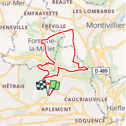
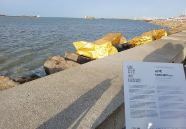
Randonnée V.T.T. de 14,2 km à découvrir à Normandie, Seine-Maritime, Le Havre. Cette randonnée est proposée par tracegps.

Description

Bonjour à tous. Fraicheur matinale et soleil pour ce circuit VTT qui m'a bien réveillé. Il y a des bonnes montées, il ne faut pas lâcher. Bonne balade !

Profil altimétrique

Photos

Localisation

Pays :
France
Région :
Normandie
Département/Province :
Seine-Maritime
Commune :
Le Havre
Localité :
Unknown
Départ:(Dec)
Départ:(UTM)
293744 ; 5488376 (31U) N.

Randonnées à proximité

Randonnée Marche Harfleur - Turner's walk - Photo
Marche
GGHarfleur

Marche

Facile
(1)
Harfleur, Normandie, Seine-Maritime, France
7,7 km | 9,1 km-effort
3h 0min
Oui
Randonnée Marche Le Havre - Découvrir Le Havre - Photo
Marche
tracegps

Marche

Difficile
(1)
Le Havre, Normandie, Seine-Maritime, France
14,2 km | 17 km-effort
3h 30min
Oui
Randonnée A pied Fontaine-la-Mallet - Les Bassins des Vallées - Photo
A pied
PRO

A pied

Facile
Fontaine-la-Mallet, Normandie, Seine-Maritime, France
5,1 km | 6 km-effort
1h 21min
Non
Randonnée A pied Le Havre - Autour du Cap - Photo
A pied
PRO

A pied

Facile
Le Havre, Normandie, Seine-Maritime, France
4,8 km | 5,9 km-effort
1h 20min
Non
Randonnée Marche Le Havre - 076-05-Le Havre A-Midi 9km  - Photo
Marche
rvs147

Marche

Facile
(1)
Le Havre, Normandie, Seine-Maritime, France
8,8 km | 11,5 km-effort
2h 49min
Oui
Randonnée Marche Le Havre - le havre parcs - Photo
Marche
AACLARANDO

Marche

Difficile
Le Havre, Normandie, Seine-Maritime, France
12,1 km | 14,5 km-effort
3h 25min
Oui
Randonnée Marche Le Havre - parc rouelles mini pas - Photo
Marche
chriscouz

Marche

Facile
Le Havre, Normandie, Seine-Maritime, France
3,1 km | 3,6 km-effort
49min
Oui
Randonnée Marche Le Havre - Le havre front de mer - Photo
Marche
chriscouz

Marche

Moyen
Le Havre, Normandie, Seine-Maritime, France
8,2 km | 9,7 km-effort
3h 14min
Oui
Randonnée Marche Harfleur - Harfleur Gonfreville Harfleur - Photo
Marche
MarcherEnsemble

Marche

Très facile
Harfleur, Normandie, Seine-Maritime, France
9,1 km | 11 km-effort
2h 14min
Oui


Fermer
Mes abonnements