Randonnée V.T.T. Gratens - Gratens - Bois de Lautignac - Photo

Gratens - Bois de Lautignac

 tracegps
tracegps

Utilisateur

© OpenStreetMap contributors
Longueur
Longueur
21 km
Altitude max
Altitude max
343 m
Dénivelé positif
Dénivelé positif
386 m
Km-Effort
Km-Effort  
26 km
Altitude min
Altitude min
230 m
Dénivelé négatif
Dénivelé négatif
386 m
Boucle
Boucle
Oui
Date de création :
2014-12-10 00:00:00.0
Dernière modification :
2014-12-10 00:00:00.0

(0 Avis)

V.T.T.
V.T.T.
1h40
Difficulté : Moyen

Scannez ce code QR pour ouvrir la randonnée dans l'application SityTrail

Application GPS de randonnée GRATUITE

Logo SityTrail SityTrail

IGN / Instituts géographiques

Télécharger SityTrail sur l'App Store Télécharger SityTrail sur Google Play

Logo SityTrail SityTrail World

Le monde est à vous

Télécharger SityTrail sur l'App Store Télécharger SityTrail sur Google Play Télécharger SityTrail sur Huawei AppGallery

À propos

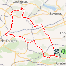
Randonnée V.T.T. de 21 km à découvrir à Occitanie, Haute-Garonne, Gratens. Cette randonnée est proposée par tracegps.

Description

A la recherche du maximum de pistes, on saute de bois en Touch.

Profil altimétrique

Localisation

Pays :
France
Région :
Occitanie
Département/Province :
Haute-Garonne
Commune :
Gratens
Localité :
Unknown
Départ:(Dec)
Départ:(UTM)
346907 ; 4798943 (31T) N.

Randonnées à proximité

Randonnée V.T.T. Gratens - Boucle du Fousseret au Touch - Photo
V.T.T.
tracegps

V.T.T.

Difficile
(1)
Gratens, Occitanie, Haute-Garonne, France
32 km | 41 km-effort
2h 30min
Oui
Randonnée Vélo Bérat - Bérat - Labastide Clermont - Gratens - Photo
Vélo
tracegps

Vélo

Moyen
Bérat, Occitanie, Haute-Garonne, France
20 km | 22 km-effort
1h 30min
Oui
Randonnée A pied Savères - Le tour du lac de Savères - Photo
A pied
PRO

A pied

Facile
Savères, Occitanie, Haute-Garonne, France
3,1 km | 3,7 km-effort
50min
Non
Randonnée Marche Gratens - Randonnée en boucle à Gratens - Photo
Marche
tracegps

Marche

Moyen
Gratens, Occitanie, Haute-Garonne, France
12,1 km | 15 km-effort
3h 0min
Oui
Randonnée V.T.T. Gratens - Boucle autour de Gratens - Photo
V.T.T.
tracegps

V.T.T.

Moyen
Gratens, Occitanie, Haute-Garonne, France
12,2 km | 15,4 km-effort
1h 30min
Oui
Randonnée Marche Labastide-Clermont - Clermont alain - Photo
Marche
ClubAgeHeureux

Marche

Difficile
Labastide-Clermont, Occitanie, Haute-Garonne, France
10,8 km | 12,6 km-effort
2h 20min
Oui
Randonnée Marche Le Fousseret - Alain fousseret - Photo
Marche
ClubAgeHeureux

Marche

Difficile
Le Fousseret, Occitanie, Haute-Garonne, France
10,6 km | 12,7 km-effort
2h 9min
Oui
Randonnée Marche Le Fousseret - Le fousseret court fait 2024 - Photo
Marche
pidjam

Marche

Facile
Le Fousseret, Occitanie, Haute-Garonne, France
10,7 km | 12,9 km-effort
2h 26min
Oui
Randonnée Marche Bois-de-la-Pierre - Peyssies lac fait 2023 - Photo
Marche
pidjam

Marche

Très facile
Bois-de-la-Pierre, Occitanie, Haute-Garonne, France
7,8 km | 8,2 km-effort
1h 47min
Oui


Fermer
Mes abonnements