Randonnée Marche Aix-Noulette - Randonnée Aix Noulette - Notre Dame de Lorette - Photo

Randonnée Aix Noulette - Notre Dame de Lorette

 tracegps
tracegps

Utilisateur

© OpenStreetMap contributors
Longueur
Longueur
10,6 km
Altitude max
Altitude max
199 m
Dénivelé positif
Dénivelé positif
198 m
Km-Effort
Km-Effort  
13,3 km
Altitude min
Altitude min
71 m
Dénivelé négatif
Dénivelé négatif
198 m
Boucle
Boucle
Oui
Date de création :
2014-12-10 00:00:00.0
Dernière modification :
2014-12-10 00:00:00.0

(0 Avis)

Marche
Marche
2h00
Difficulté : Moyen

Scannez ce code QR pour ouvrir la randonnée dans l'application SityTrail

Application GPS de randonnée GRATUITE

Logo SityTrail SityTrail

IGN / Instituts géographiques

Télécharger SityTrail sur l'App Store Télécharger SityTrail sur Google Play

Logo SityTrail SityTrail World

Le monde est à vous

Télécharger SityTrail sur l'App Store Télécharger SityTrail sur Google Play Télécharger SityTrail sur Huawei AppGallery

À propos

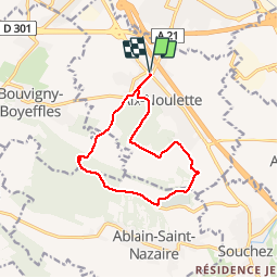
Randonnée Marche de 10,6 km à découvrir à Hauts-de-France, Pas-de-Calais, Aix-Noulette. Cette randonnée est proposée par tracegps.

Description

Randonnée au départ de Aix-Noulette dans les collines d'Artois avec montée au cimetière de Lorette.

Profil altimétrique

Photos

Localisation

Pays :
France
Région :
Hauts-de-France
Département/Province :
Pas-de-Calais
Commune :
Aix-Noulette
Localité :
Unknown
Départ:(Dec)
Départ:(UTM)
479481 ; 5586152 (31U) N.

Randonnées à proximité

Randonnée Marche Liévin - 50 km Lievin en nocturne - Photo
Marche
tracegps

Marche

Très difficile
(1)
Liévin, Hauts-de-France, Pas-de-Calais, France
52 km | 61 km-effort
9h 0min
Oui
Randonnée Marche Angres - randonnée pinchonvalles - Photo
Marche
Chene62

Marche

Très difficile
Angres, Hauts-de-France, Pas-de-Calais, France
27 km | 0 m-effort
3h 24min
Non
Randonnée Course à pied Aix-Noulette - aix noulette sity guide 25,3 km D530+ - Photo
Course à pied
jamboxland

Course à pied

Moyen
Aix-Noulette, Hauts-de-France, Pas-de-Calais, France
23 km | 30 km-effort
2h 45min
Oui
Randonnée Marche Souchez - Souchez-Noulette-Lorette-Ablain - Photo
Marche
tracegps

Marche

Facile
Souchez, Hauts-de-France, Pas-de-Calais, France
6,7 km | 8,4 km-effort
1h 45min
Oui
Randonnée Marche Ablain-Saint-Nazaire - lorette août 23 - Photo
Marche
Benoît66

Marche

Difficile
Ablain-Saint-Nazaire, Hauts-de-France, Pas-de-Calais, France
11,8 km | 15,6 km-effort
2h 29min
Non
Randonnée Marche Ablain-Saint-Nazaire - autour d'Alain Saint nazaire - Photo
Marche
temmichel

Marche

Moyen
Ablain-Saint-Nazaire, Hauts-de-France, Pas-de-Calais, France
8,9 km | 11,1 km-effort
2h 4min
Oui
Randonnée Marche Souchez - Lorette et Carency CAF - Photo
Marche
reneperrin

Marche

Facile
Souchez, Hauts-de-France, Pas-de-Calais, France
21 km | 25 km-effort
5h 24min
Oui
Randonnée Marche Bouvigny-Boyeffles - bouvigny - Photo
Marche
totof62

Marche

Difficile
Bouvigny-Boyeffles, Hauts-de-France, Pas-de-Calais, France
14,2 km | 17,3 km-effort
3h 54min
Oui
Randonnée Marche Hersin-Coupigny -  Les Cavaliers N°2 à Hersin Coupigny - Photo
Marche
tracegps

Marche

Moyen
Hersin-Coupigny, Hauts-de-France, Pas-de-Calais, France
13,6 km | 15,9 km-effort
3h 15min
Oui


Fermer
Mes abonnements