Randonnée V.T.T. Ménil-Hubert-sur-Orne - Rando raid du Pont d'Ouilly - 35 km - 2011 - Photo

Rando raid du Pont d'Ouilly - 35 km - 2011

 tracegps
tracegps

Utilisateur

© OpenStreetMap contributors
Longueur
Longueur
34 km
Altitude max
Altitude max
239 m
Dénivelé positif
Dénivelé positif
681 m
Km-Effort
Km-Effort  
43 km
Altitude min
Altitude min
45 m
Dénivelé négatif
Dénivelé négatif
687 m
Boucle
Boucle
Non
Date de création :
2014-12-10 00:00:00.0
Dernière modification :
2014-12-10 00:00:00.0

(0 Avis)

V.T.T.
V.T.T.
2h30
Difficulté : Difficile

Scannez ce code QR pour ouvrir la randonnée dans l'application SityTrail

Application GPS de randonnée GRATUITE

Logo SityTrail SityTrail

IGN / Instituts géographiques

Télécharger SityTrail sur l'App Store Télécharger SityTrail sur Google Play

Logo SityTrail SityTrail World

Le monde est à vous

Télécharger SityTrail sur l'App Store Télécharger SityTrail sur Google Play Télécharger SityTrail sur Huawei AppGallery

À propos

Randonnée V.T.T. de 34 km à découvrir à Normandie, Orne, Ménil-Hubert-sur-Orne. Cette randonnée est proposée par tracegps.

Description

Circuit de 35 km - Partie du circuit du raid de Pont d'Ouilly - 28/08/2011.

Profil altimétrique

Photos

Localisation

Pays :
France
Région :
Normandie
Département/Province :
Orne
Commune :
Ménil-Hubert-sur-Orne
Localité :
Unknown
Départ:(Dec)
Départ:(UTM)
689906 ; 5416270 (30U) N.

Randonnées à proximité

Randonnée V.T.T. Pont-d'Ouilly - La Petite Suisse Normande 2014 - Pont-d'Ouilly - Photo
V.T.T.
tracegps

V.T.T.

Difficile
(1)
Pont-d'Ouilly, Normandie, Calvados, France
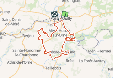
41 km | 54 km-effort
3h 30min
Oui
Randonnée Marche Saint-Philbert-sur-Orne - Autour des roches d'oetre - Photo
Marche
phi14

Marche

Facile
(3)
Saint-Philbert-sur-Orne, Normandie, Orne, France
9,7 km | 12,4 km-effort
2h 30min
Oui
Randonnée Marche Saint-Philbert-sur-Orne - Roche d’oëtre sentier du Granite - Photo
Marche
zefreefly

Marche

Très facile
Saint-Philbert-sur-Orne, Normandie, Orne, France
10,1 km | 12,7 km-effort
2h 43min
Oui
Randonnée Marche Le Vey - Clécy - Photo
Marche
zefreefly

Marche

Facile
Le Vey, Normandie, Calvados, France
14,8 km | 20 km-effort
3h 51min
Oui
Randonnée Marche Saint-Philbert-sur-Orne - Circuit des méandres  - Photo
Marche
JLPIERSON

Marche

Moyen
Saint-Philbert-sur-Orne, Normandie, Orne, France
6,4 km | 8,4 km-effort
1h 54min
Oui
Randonnée Marche Ménil-Hubert-sur-Orne - De Rouvroy aux Roches d'Oetre par le sentier des Méandres  - Photo
Marche
Ecureuiltrailer

Marche

Moyen
Ménil-Hubert-sur-Orne, Normandie, Orne, France
7,1 km | 9,3 km-effort
2h 1min
Oui
Randonnée A pied Saint-Philbert-sur-Orne - Entre Orne et Rouvre - Photo
A pied
PRO

A pied

Facile
Saint-Philbert-sur-Orne, Normandie, Orne, France
7,7 km | 10,3 km-effort
2h 19min
Oui
Randonnée A pied Pont-d'Ouilly - Circuit du Val la Hère - Photo
A pied
PRO

A pied

Facile
Pont-d'Ouilly, Normandie, Calvados, France
6,7 km | 9,4 km-effort
2h 7min
Oui
Randonnée A pied La Pommeraye - Les Rochers de Briesvieille - Photo
A pied
PRO

A pied

Facile
La Pommeraye, Normandie, Calvados, France
9,1 km | 12,9 km-effort
2h 55min
Non


Fermer
Mes abonnements