Randonnée Marche Manosque - MANOSQUE Montaigu  o - Photo
 RobinMicheline
RobinMicheline

Utilisateur

© OpenStreetMap contributors
Longueur
Longueur
12,5 km
Altitude max
Altitude max
684 m
Dénivelé positif
Dénivelé positif
425 m
Km-Effort
Km-Effort  
18,5 km
Altitude min
Altitude min
415 m
Dénivelé négatif
Dénivelé négatif
537 m
Boucle
Boucle
Non
Date de création :
2019-05-16 07:39:43.15
Dernière modification :
2020-01-22 17:54:52.975

(0 Avis)

Marche
Marche
3h48
Difficulté : Inconnu

Scannez ce code QR pour ouvrir la randonnée dans l'application SityTrail

Application GPS de randonnée GRATUITE

Logo SityTrail SityTrail

IGN / Instituts géographiques

Télécharger SityTrail sur l'App Store Télécharger SityTrail sur Google Play

Logo SityTrail SityTrail World

Le monde est à vous

Télécharger SityTrail sur l'App Store Télécharger SityTrail sur Google Play Télécharger SityTrail sur Huawei AppGallery

À propos

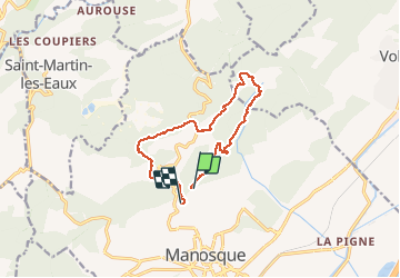
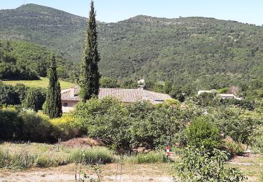
Randonnée Marche de 12,5 km à découvrir à Provence-Alpes-Côte d'Azur, Alpes-de-Haute-Provence, Manosque. Cette randonnée est proposée par RobinMicheline.

Description

13 kms 5 h 540 m deni  A REFAIRE

Profil altimétrique

Points d'intérêt

Point d'intérêt Volx - Point 1 - Photo
RobinMicheline
VOLX 
Point d'intérêt Volx - Point 2 - Photo
RobinMicheline
VOLX 

Localisation

Pays :
France
Région :
Provence-Alpes-Côte d'Azur
Département/Province :
Alpes-de-Haute-Provence
Commune :
Manosque
Localité :
Unknown
Départ:(Dec)
Départ:(UTM)
723368 ; 4858802 (31T) N.

Randonnées à proximité

Randonnée Marche Manosque - Le Val des Chats, avant le col de la Mort d'Imbert. - Photo
Marche
liocol

Marche

Facile
(2)
Manosque, Provence-Alpes-Côte d'Azur, Alpes-de-Haute-Provence, France
4,7 km | 6,5 km-effort
1h 23min
Oui
Randonnée V.T.T. Volx - Volx/Montaigu/Bellevue/La Garde - Photo
V.T.T.
remizzi

V.T.T.

Moyen
(1)
Volx, Provence-Alpes-Côte d'Azur, Alpes-de-Haute-Provence, France
16,2 km | 24 km-effort
1h 33min
Oui
Randonnée Marche Manosque - Le tour de la borie '' pain de sucre ''  - Photo
Marche
PITOUSSAINT

Marche

Facile
(1)
Manosque, Provence-Alpes-Côte d'Azur, Alpes-de-Haute-Provence, France
5,1 km | 7,4 km-effort
1h 43min
Oui
Randonnée Marche Manosque - Quartier des Espels, départ Piscine. - Photo
Marche
liocol

Marche

Facile
(1)
Manosque, Provence-Alpes-Côte d'Azur, Alpes-de-Haute-Provence, France
4,8 km | 7,3 km-effort
1h 50min
Oui
Randonnée Marche Manosque - MANOSQUE VOLX PAR LES COLLINES O S - Photo
Marche
RobinMicheline

Marche

Difficile
Manosque, Provence-Alpes-Côte d'Azur, Alpes-de-Haute-Provence, France
17,7 km | 24 km-effort
4h 15min
Oui
Randonnée Trail Volx - volx - Photo
Trail
francislassauce

Trail

Difficile
Volx, Provence-Alpes-Côte d'Azur, Alpes-de-Haute-Provence, France
9,2 km | 14,7 km-effort
1h 43min
Oui
Randonnée Marche Manosque - 1Les speels, le relais, le pain de sucre. Depart Crématoriome. - Photo
Marche
liocol

Marche

Moyen
(1)
Manosque, Provence-Alpes-Côte d'Azur, Alpes-de-Haute-Provence, France
6,1 km | 9,7 km-effort
2h 4min
Oui
Randonnée Marche Saint-Michel-l'Observatoire - de Saint Martin les eaux à biabaux . la chapelle de hurage - Photo
Marche
Roger

Marche

Facile
Saint-Michel-l'Observatoire, Provence-Alpes-Côte d'Azur, Alpes-de-Haute-Provence, France
9,4 km | 13,1 km-effort
2h 51min
Oui
Randonnée Marche Saint-Martin-les-Eaux - 1Domaine de Bourne - Photo
Marche
liocol

Marche

Moyen
Saint-Martin-les-Eaux, Provence-Alpes-Côte d'Azur, Alpes-de-Haute-Provence, France
5,6 km | 8,3 km-effort
2h 2min
Oui


Fermer
Mes abonnements