Randonnée Marche Saint-Mards-en-Othe - De place en place - Saint Mards en Othe - Photo

De place en place - Saint Mards en Othe

 tracegps
tracegps

Utilisateur

© OpenStreetMap contributors
Longueur
Longueur
16,1 km
Altitude max
Altitude max
249 m
Dénivelé positif
Dénivelé positif
276 m
Km-Effort
Km-Effort  
19,8 km
Altitude min
Altitude min
149 m
Dénivelé négatif
Dénivelé négatif
276 m
Boucle
Boucle
Oui
Date de création :
2014-12-10 00:00:00.0
Dernière modification :
2014-12-10 00:00:00.0

(1 Avis)

Marche
Marche
4h00
Difficulté : Difficile

Scannez ce code QR pour ouvrir la randonnée dans l'application SityTrail

Application GPS de randonnée GRATUITE

Logo SityTrail SityTrail

IGN / Instituts géographiques

Télécharger SityTrail sur l'App Store Télécharger SityTrail sur Google Play

Logo SityTrail SityTrail World

Le monde est à vous

Télécharger SityTrail sur l'App Store Télécharger SityTrail sur Google Play Télécharger SityTrail sur Huawei AppGallery

À propos

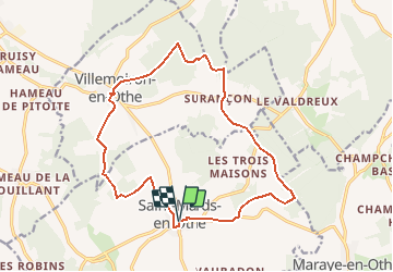
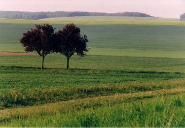
Randonnée Marche de 16,1 km à découvrir à Grand Est, Aube, Saint-Mards-en-Othe. Cette randonnée est proposée par tracegps.

Description

Circuit proposé par l’Office de Tourisme du Pays d’Othe. Départ de la place de la mairie de Saint Mards en Othe. Retrouvez ce circuit sur le site de l’Office du Tourisme. Circuit interdit en période de chasse. Ce circuit a été numérisé par les randonneurs du CODEPEM. Merci à Jean-Marie.

Profil altimétrique

Photos

Localisation

Pays :
France
Région :
Grand Est
Département/Province :
Aube
Commune :
Saint-Mards-en-Othe
Localité :
Unknown
Départ:(Dec)
Départ:(UTM)
559450 ; 5335782 (31U) N.

Commentaires

Veuillez vous connecter pour laisser un commentaire ou une note


circuit très agréable ,un peu court donc j'ai rajouté 4km pour avoir une rando à la journée


Randonnées à proximité

Randonnée Marche Maraye-en-Othe - Maraye (11+13km) le 21/07/2020 - Photo
Marche
francis1952

Marche

Moyen
Maraye-en-Othe, Grand Est, Aube, France
25 km | 30 km-effort
5h 14min
Oui
Randonnée Marche Aix-Villemaur-Pâlis - La Vove - Aix en Othe - Photo
Marche
tracegps

Marche

Moyen
(1)
Aix-Villemaur-Pâlis, Grand Est, Aube, France
10,2 km | 12,3 km-effort
2h 30min
Oui
Randonnée Marche Aix-Villemaur-Pâlis - La Vove - Bois de la Brosse - Photo
Marche
Daneel-89

Marche

Facile
Aix-Villemaur-Pâlis, Grand Est, Aube, France
9,8 km | 11,9 km-effort
3h 0min
Oui
Randonnée Vélo Villemoiron-en-Othe - Circuit de Villemoiron en Othe - Photo
Vélo
tracegps

Vélo

Facile
Villemoiron-en-Othe, Grand Est, Aube, France
33 km | 39 km-effort
1h 45min
Oui
Randonnée Vélo Saint-Mards-en-Othe - Circuit de Saint-Mards-en-Othe - Photo
Vélo
tracegps

Vélo

Facile
Saint-Mards-en-Othe, Grand Est, Aube, France
26 km | 31 km-effort
1h 30min
Oui
Randonnée Marche Maraye-en-Othe - Le circuit des Voirloups - Maraye-en-Othe - Photo
Marche
tracegps

Marche

Très difficile
(1)
Maraye-en-Othe, Grand Est, Aube, France
19,1 km | 24 km-effort
4h 49min
Oui
Randonnée Marche Maraye-en-Othe - Les Vergers de Champcharme - Maraye-en-Othe - Photo
Marche
tracegps

Marche

Difficile
Maraye-en-Othe, Grand Est, Aube, France
14,3 km | 18,6 km-effort
3h 34min
Oui
Randonnée Marche Maraye-en-Othe - Maraye,Nogent,Vosnon,Puiseaux,Chenu,Chamsicourt - Photo
Marche
francis1952

Marche

Difficile
Maraye-en-Othe, Grand Est, Aube, France
31 km | 39 km-effort
6h 11min
Oui
Randonnée Marche Maraye-en-Othe - Maraye 26km le 08.10.2021 - Photo
Marche
francis1952

Marche

Difficile
Maraye-en-Othe, Grand Est, Aube, France
26 km | 32 km-effort
5h 27min
Oui


Fermer
Mes abonnements