Randonnée Marche Plestin-les-Grèves - Circuit de la chapelle Sainte Barbe - Plestin-les-Grèves - Photo

Circuit de la chapelle Sainte Barbe - Plestin-les-Grèves

 tracegps
tracegps

Utilisateur

© OpenStreetMap contributors
Longueur
Longueur
7,7 km
Altitude max
Altitude max
54 m
Dénivelé positif
Dénivelé positif
167 m
Km-Effort
Km-Effort  
9,9 km
Altitude min
Altitude min
2 m
Dénivelé négatif
Dénivelé négatif
165 m
Boucle
Boucle
Oui
Date de création :
2014-12-10 00:00:00.0
Dernière modification :
2014-12-10 00:00:00.0

(1 Avis)

Marche
Marche
2h00
Difficulté : Facile

Scannez ce code QR pour ouvrir la randonnée dans l'application SityTrail

Application GPS de randonnée GRATUITE

Logo SityTrail SityTrail

IGN / Instituts géographiques

Télécharger SityTrail sur l'App Store Télécharger SityTrail sur Google Play

Logo SityTrail SityTrail World

Le monde est à vous

Télécharger SityTrail sur l'App Store Télécharger SityTrail sur Google Play Télécharger SityTrail sur Huawei AppGallery

À propos

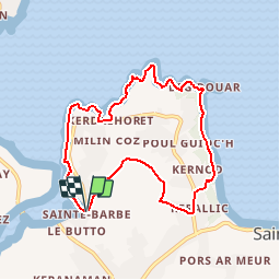
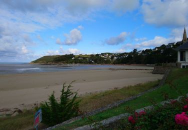
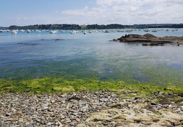
Randonnée Marche de 7,7 km à découvrir à Bretagne, Côtes-d'Armor, Plestin-les-Grèves. Cette randonnée est proposée par tracegps.

Description

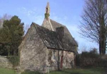
Circuit proposé par Office de Tourisme de la Lieue de Grève. Départ de la chapelle Sainte Barbe à Plestin-les-Grèves. Retrouvez le circuit sur le site de la Communauté de Communes d’Evran.

Profil altimétrique

Photos

Localisation

Pays :
France
Région :
Bretagne
Département/Province :
Côtes-d'Armor
Commune :
Plestin-les-Grèves
Localité :
Unknown
Départ:(Dec)
Départ:(UTM)
453318 ; 5391094 (30U) N.

Commentaires

Veuillez vous connecter pour laisser un commentaire ou une note


Magnifique boucle


Randonnées à proximité

Randonnée V.T.T. Plestin-les-Grèves - Circuit des chapelles, coté terre - Plestin-les-Grèves - Photo
V.T.T.
tracegps

V.T.T.

Moyen
(1)
Plestin-les-Grèves, Bretagne, Côtes-d'Armor, France
17,1 km | 20 km-effort
2h 0min
Oui
Randonnée Marche Saint-Michel-en-Grève - Saint-Michel-en-Grève - GR34 le Grand Rocher - 12km 300m 4h05 - 2023 09 13 - Photo
Marche
Orcal37

Marche

Difficile
Saint-Michel-en-Grève, Bretagne, Côtes-d'Armor, France
12,1 km | 16 km-effort
4h 5min
Oui
Randonnée Marche Saint-Michel-en-Grève - Saint-Michel-en-Grève - GR34 Beg ar Forn Église - 7.7km 200m 2h15 (50mn) - 2023 09 13 - Photo
Marche
Orcal37

Marche

Moyen
Saint-Michel-en-Grève, Bretagne, Côtes-d'Armor, France
7,7 km | 10,4 km-effort
2h 15min
Oui
Randonnée Marche Guimaëc - Gr34 Poul Rodou à Venizella - Photo
Marche
Corto2023

Marche

Facile
Guimaëc, Bretagne, Finistère, France
3,3 km | 4,3 km-effort
55min
Non
Randonnée A pied Trédrez-Locquémeau - Circuit des Falaises de Trédrez - Photo
A pied
PRO

A pied

Facile
Trédrez-Locquémeau, Bretagne, Côtes-d'Armor, France
11,2 km | 14,1 km-effort
3h 11min
Oui
Randonnée Marche Saint-Michel-en-Grève - Bretagne nord J6pm : St Michel en Grève - Locquémau - Photo
Marche
chessyca

Marche

Très facile
Saint-Michel-en-Grève, Bretagne, Côtes-d'Armor, France
8,2 km | 10,3 km-effort
2h 19min
Non
Randonnée Marche Plestin-les-Grèves - Locquirec 07-06-19 - Photo
Marche
nolsim

Marche

Moyen
Plestin-les-Grèves, Bretagne, Côtes-d'Armor, France
12,4 km | 14,7 km-effort
3h 38min
Non
Randonnée Marche Locquirec - Petit tour de Loquirec - Photo
Marche

Marche

Très facile
Locquirec, Bretagne, Finistère, France
4,6 km | 5,7 km-effort
1h 12min
Oui
Randonnée Marche Plestin-les-Grèves - Plestin les grèves - Photo
Marche
Marie-Claire-mcp

Marche

Moyen
Plestin-les-Grèves, Bretagne, Côtes-d'Armor, France
11,9 km | 14,7 km-effort
3h 10min
Oui


Fermer
Mes abonnements