Randonnée Vélo Bercenay-en-Othe - Circuit de Bercenay-en-Othe  - Photo

Circuit de Bercenay-en-Othe

 tracegps
tracegps

Utilisateur

© OpenStreetMap contributors
Longueur
Longueur
27 km
Altitude max
Altitude max
306 m
Dénivelé positif
Dénivelé positif
369 m
Km-Effort
Km-Effort  
32 km
Altitude min
Altitude min
168 m
Dénivelé négatif
Dénivelé négatif
371 m
Boucle
Boucle
Oui
Date de création :
2014-12-10 00:00:00.0
Dernière modification :
2014-12-10 00:00:00.0

(0 Avis)

Vélo
Vélo
1h30
Difficulté : Facile

Scannez ce code QR pour ouvrir la randonnée dans l'application SityTrail

Application GPS de randonnée GRATUITE

Logo SityTrail SityTrail

IGN / Instituts géographiques

Télécharger SityTrail sur l'App Store Télécharger SityTrail sur Google Play

Logo SityTrail SityTrail World

Le monde est à vous

Télécharger SityTrail sur l'App Store Télécharger SityTrail sur Google Play Télécharger SityTrail sur Huawei AppGallery

À propos

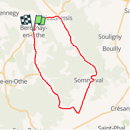
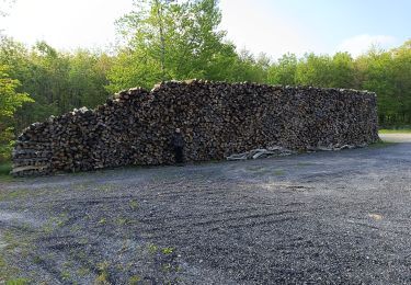
Randonnée Vélo de 27 km à découvrir à Grand Est, Aube, Bercenay-en-Othe. Cette randonnée est proposée par tracegps.

Description

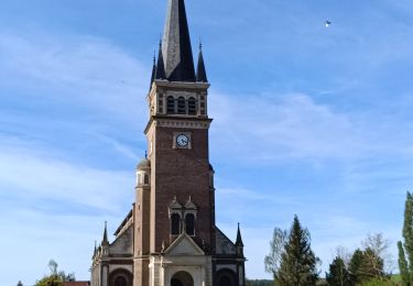
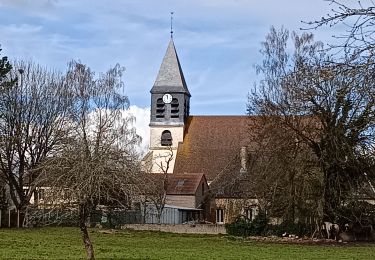
Circuit proposé par l'office de Tourisme du Pays d'Othe, vallée de la Vanne et le Cyclo Club Othéen. Départ de l'église de Bercenay-en-Othe. Retrouvez le circuit a télécharger sur le site de l'office de tourisme du Pays d'Othe, vallée de la Vanne.

Profil altimétrique

Photos

Localisation

Pays :
France
Région :
Grand Est
Département/Province :
Aube
Commune :
Bercenay-en-Othe
Localité :
Unknown
Départ:(Dec)
Départ:(UTM)
566209 ; 5339834 (31U) N.

Randonnées à proximité

Randonnée Marche Prugny - Montbernange - Photo
Marche
FPortier

Marche

Moyen
(1)
Prugny, Grand Est, Aube, France
9,4 km | 12 km-effort
2h 19min
Oui
Randonnée Marche Chennegy - Le chemin du patrimoine du Valdreux - Photo
Marche
gildascb

Marche

Très facile
(1)
Chennegy, Grand Est, Aube, France
8,6 km | 10,5 km-effort
1h 57min
Oui
Randonnée Marche Vauchassis - Randonnée Bucey 23 04 2024 - Photo
Marche
FPortier

Marche

Difficile
Vauchassis, Grand Est, Aube, France
10,5 km | 13,4 km-effort
3h 5min
Oui
Randonnée Vélo électrique Vauchassis - Balade VAE Pays d Othe - Photo
Vélo électrique
FPortier

Vélo électrique

Très facile
Vauchassis, Grand Est, Aube, France
56 km | 66 km-effort
5h 15min
Oui
Randonnée Marche Vauchassis - Balade Forêt communale de Vauchassis - Photo
Marche
FPortier

Marche

Moyen
Vauchassis, Grand Est, Aube, France
7,5 km | 9,1 km-effort
2h 26min
Oui
Randonnée Marche Vauchassis - Vauchassis Bercenay Vauchassis - Photo
Marche
FPortier

Marche

Difficile
Vauchassis, Grand Est, Aube, France
10,3 km | 13 km-effort
3h 2min
Oui
Randonnée Marche Vauchassis - Randonnée Grands Bois Vauchassis - Photo
Marche
FPortier

Marche

Moyen
Vauchassis, Grand Est, Aube, France
9,7 km | 12 km-effort
2h 51min
Oui
Randonnée Vélo électrique Vauchassis - Balade VAE Pays d'Othe - Photo
Vélo électrique
FPortier

Vélo électrique

Moyen
Vauchassis, Grand Est, Aube, France
46 km | 56 km-effort
3h 38min
Oui
Randonnée Marche Chennegy - Randonnée à Chennegy - Photo
Marche
FPortier

Marche

Difficile
Chennegy, Grand Est, Aube, France
10,6 km | 12,4 km-effort
3h 5min
Oui


Fermer
Mes abonnements