Randonnée Marche Caylus - Rallye FGI - Photo
 albert13
albert13

Utilisateur

© OpenStreetMap contributors
Longueur
Longueur
19,6 km
Altitude max
Altitude max
369 m
Dénivelé positif
Dénivelé positif
326 m
Km-Effort
Km-Effort  
24 km
Altitude min
Altitude min
208 m
Dénivelé négatif
Dénivelé négatif
311 m
Boucle
Boucle
Non
Date de création :
2014-12-10 00:00:00.0
Dernière modification :
2014-12-10 00:00:00.0

(0 Avis)

Marche
Marche
--
Difficulté : Moyen

Scannez ce code QR pour ouvrir la randonnée dans l'application SityTrail

Application GPS de randonnée GRATUITE

Logo SityTrail SityTrail

IGN / Instituts géographiques

Télécharger SityTrail sur l'App Store Télécharger SityTrail sur Google Play

Logo SityTrail SityTrail World

Le monde est à vous

Télécharger SityTrail sur l'App Store Télécharger SityTrail sur Google Play Télécharger SityTrail sur Huawei AppGallery

À propos

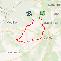
Randonnée Marche de 19,6 km à découvrir à Occitanie, Tarn-et-Garonne, Caylus. Cette randonnée est proposée par albert13.

Profil altimétrique

Points d'intérêt

Point d'intérêt Caylus - P1 - Photo
albert13
CAYLUS 
Point d'intérêt Caylus - P2 - Photo
albert13
CAYLUS 
Point d'intérêt Caylus - P3 - Photo
albert13
CAYLUS 
Point d'intérêt Caylus - B1 - Photo
albert13
CAYLUS 
Point d'intérêt Caylus - O2 - Photo
albert13
CAYLUS 
Point d'intérêt Caylus - O1 - Photo
albert13
CAYLUS 
Point d'intérêt Caylus - R3 - Photo
albert13
CAYLUS 
Point d'intérêt Caylus - R2 - Photo
albert13
CAYLUS 
Point d'intérêt Caylus - R1 - Photo
albert13
CAYLUS 
Point d'intérêt Puylaroque - B2 - Photo
albert13
PUYLAROQUE 
Point d'intérêt Puylaroque - B3 - Photo
albert13
PUYLAROQUE 
Point d'intérêt Puylaroque - detour - Photo
albert13
PUYLAROQUE 
Point d'intérêt Caylus - detour - Photo
albert13
CAYLUS 

Localisation

Pays :
France
Région :
Occitanie
Département/Province :
Tarn-et-Garonne
Commune :
Caylus
Localité :
Unknown
Départ:(Dec)
Départ:(UTM)
400029 ; 4903297 (31T) N.

Randonnées à proximité

Randonnée Marche Lacapelle-Livron - Lacapelle-Livron : Chemin des anciens moulins, cascade pétrifiante - Photo
Marche
houbart

Marche

Moyen
(1)
Lacapelle-Livron, Occitanie, Tarn-et-Garonne, France
7,2 km | 9,6 km-effort
2h 11min
Oui
Randonnée sport Saint-Projet - St projet beauregard - Photo
sport
Glurps

sport

Très facile
Saint-Projet, Occitanie, Tarn-et-Garonne, France
15,7 km | 18,8 km-effort
Inconnu
Oui
Randonnée V.T.T. Caylus - VTT Caylus 45km  - Photo
V.T.T.
Levillefranchois

V.T.T.

Difficile
Caylus, Occitanie, Tarn-et-Garonne, France
44 km | 57 km-effort
Inconnu
Oui
Randonnée Marche Caylus - 211115 Rando ARAT Caylus - Photo
Marche
VIRGULIN

Marche

Moyen
Caylus, Occitanie, Tarn-et-Garonne, France
14,8 km | 18,6 km-effort
5h 36min
Oui
Randonnée Autre activité Caylus - 12.5 km - Photo
Autre activité
albert13

Autre activité

Très facile
Caylus, Occitanie, Tarn-et-Garonne, France
15,3 km | 17,9 km-effort
Inconnu
Oui
Randonnée Marche nordique Caylus - Caylus MN - Photo
Marche nordique
AnnieBernhard

Marche nordique

Très facile
Caylus, Occitanie, Tarn-et-Garonne, France
8,4 km | 10 km-effort
Inconnu
Oui
Randonnée Marche Caylus -  Lacapelle Livron- cascade pétrifiante  - Photo
Marche
houbart

Marche

Moyen
Caylus, Occitanie, Tarn-et-Garonne, France
8,5 km | 11,1 km-effort
2h 31min
Oui
Randonnée Marche Saint-Projet - boucle saillagol - Photo
Marche
BernardEsteban

Marche

Moyen
Saint-Projet, Occitanie, Tarn-et-Garonne, France
19,1 km | 23 km-effort
5h 47min
Oui
Randonnée Marche Caylus - petit bois du causse - Photo
Marche
VERO974

Marche

Facile
Caylus, Occitanie, Tarn-et-Garonne, France
14,4 km | 18,7 km-effort
2h 37min
Oui


Fermer
Mes abonnements