Randonnée Marche Portovenere - La Spezia - Isola Palmaria Portovenere - Photo

La Spezia - Isola Palmaria Portovenere

 phidge
phidge

Utilisateur

© OpenStreetMap contributors
Longueur
Longueur
7,1 km
Altitude max
Altitude max
182 m
Dénivelé positif
Dénivelé positif
233 m
Km-Effort
Km-Effort  
10,2 km
Altitude min
Altitude min
0 m
Dénivelé négatif
Dénivelé négatif
227 m
Boucle
Boucle
Non
Date de création :
2019-01-20 16:38:24.666
Dernière modification :
2019-01-20 16:38:24.689

(0 Avis)

Marche
Marche
--
Difficulté : Inconnu

Scannez ce code QR pour ouvrir la randonnée dans l'application SityTrail

Application GPS de randonnée GRATUITE

Logo SityTrail SityTrail

IGN / Instituts géographiques

Télécharger SityTrail sur l'App Store Télécharger SityTrail sur Google Play

Logo SityTrail SityTrail World

Le monde est à vous

Télécharger SityTrail sur l'App Store Télécharger SityTrail sur Google Play Télécharger SityTrail sur Huawei AppGallery

À propos

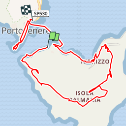
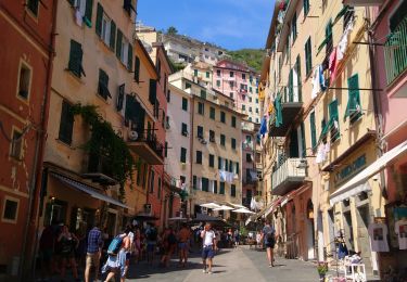
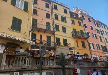
Randonnée Marche de 7,1 km à découvrir à Ligurie, La Spezia, Portovenere. Cette randonnée est proposée par phidge.

Description

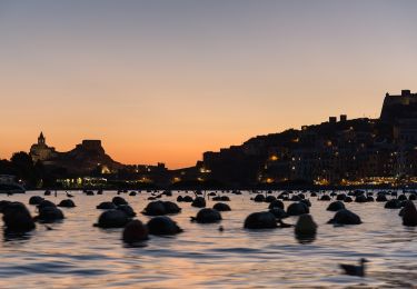
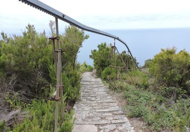
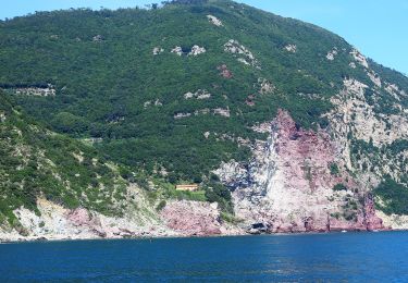
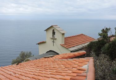
Mit einem "traditionsreichen" Minitaxiboot (nur dieses hat scheinbar die alleinige Lizenz zum Übersetzen) kommt man auf die Insel mit dem schönen Sandstrand der Portovenerer. Los gehts dann auf den Berg. Von diesem Weg aus hat man Eindrücke von Portovenere wie ein gemaltes Bild. Wer viele Menschen um sich braucht, ist hier aber auf dem falschen Pfad (und der hat noch nichteinmal Wegeschilder). Denn es gibt hier nur Wald, Blumenwiesen, unendlichen Meeresblick, die Festung (ist vom aktiven Militär besetzt, kein Zugang) - und ein Gasthaus mit lecker Fisch und Sonnenuntergangsblick über das Meer.

Profil altimétrique

Points d'intérêt

Point d'intérêt Portovenere - Fort - Photo
phidge
PORTOVENERE 
Point d'intérêt Portovenere - Locanda - Photo
phidge
PORTOVENERE 
Point d'intérêt Portovenere - Palmaria - Photo
phidge
PORTOVENERE 
Point d'intérêt Portovenere - Portovenere - Photo
phidge
PORTOVENERE 

Localisation

Pays :
Italie
Région :
Ligurie
Département/Province :
La Spezia
Commune :
Portovenere
Localité :
Unknown
Départ:(Dec)
Départ:(UTM)
567153 ; 4877598 (32T) N.

Randonnées à proximité

Randonnée A pied Lerici - San Terenzo - Pozzuolo – sella Pin Bon – Trebiano - Photo
A pied
PRO

A pied

Facile
Lerici, Ligurie, La Spezia, Italie
5,9 km | 9,6 km-effort
2h 11min
Non
Randonnée A pied Portovenere - Isola Palmaria (giro dell'isola) - Photo
A pied
PRO

A pied

Facile
Portovenere, Ligurie, La Spezia, Italie
6 km | 9,7 km-effort
2h 12min
Oui
Randonnée A pied La Spezia - Fabiano – Mad.na dell'Olmo – Cà Pilloa – Sella Gesuela - Photo
A pied
PRO

A pied

Facile
La Spezia, Ligurie, La Spezia, Italie
3,3 km | 5,1 km-effort
1h 10min
Non
Randonnée A pied La Spezia - Acquasanta – Campiglia – P.ta Persico - Photo
A pied
PRO

A pied

Facile
La Spezia, Ligurie, La Spezia, Italie
4,2 km | 9,3 km-effort
2h 6min
Non
Randonnée A pied La Spezia - Pegazzano – Biassa – S.Antonio – Schiara - Photo
A pied
PRO

A pied

Facile
La Spezia, Ligurie, La Spezia, Italie
6 km | 11,2 km-effort
2h 33min
Non
Randonnée Marche Portovenere - Porte Venere to Riomaggiore - Photo
Marche
zazie

Marche

Difficile
(2)
Portovenere, Ligurie, La Spezia, Italie
13,8 km | 24 km-effort
4h 48min
Non
Randonnée Marche Portovenere - Porto Venere - Riomaggiore 5.5.23  - Photo
Marche
fredetpascale

Marche

Difficile
Portovenere, Ligurie, La Spezia, Italie
13,2 km | 23 km-effort
4h 30min
Non
Randonnée Marche  - Cinque Terre Italie - Photo
Marche
GOHIER

Marche

Très difficile
, , ,
43 km | 57 km-effort
6h 8min
Non
Randonnée A pied Portovenere - Cinque Terre jour 1: Porto Venere à Riomaggiore - Photo
A pied
MathieuBourgois

A pied

Facile
Portovenere, Ligurie, La Spezia, Italie
19,1 km | 38 km-effort
1h 11min
Non


Fermer
Mes abonnements