Randonnée V.T.T. Quinson - grillon2 - Photo
 johan004
johan004

Utilisateur

© OpenStreetMap contributors
Longueur
Longueur
19 km
Altitude max
Altitude max
570 m
Dénivelé positif
Dénivelé positif
377 m
Km-Effort
Km-Effort  
24 km
Altitude min
Altitude min
362 m
Dénivelé négatif
Dénivelé négatif
377 m
Boucle
Boucle
Oui
Date de création :
2014-12-10 00:00:00.0
Dernière modification :
2014-12-10 00:00:00.0

(1 Avis)

V.T.T.
V.T.T.
--
Difficulté : Difficile

Scannez ce code QR pour ouvrir la randonnée dans l'application SityTrail

Application GPS de randonnée GRATUITE

Logo SityTrail SityTrail

IGN / Instituts géographiques

Télécharger SityTrail sur l'App Store Télécharger SityTrail sur Google Play

Logo SityTrail SityTrail World

Le monde est à vous

Télécharger SityTrail sur l'App Store Télécharger SityTrail sur Google Play Télécharger SityTrail sur Huawei AppGallery

À propos

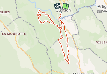
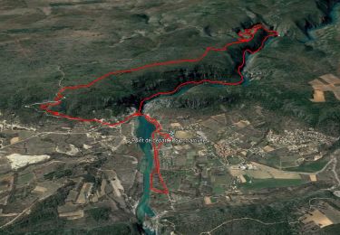
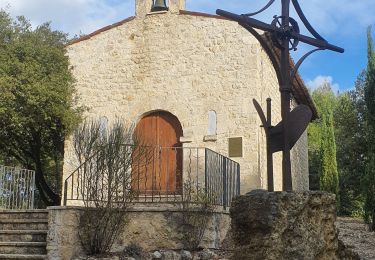
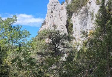
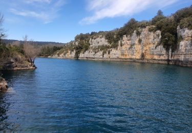
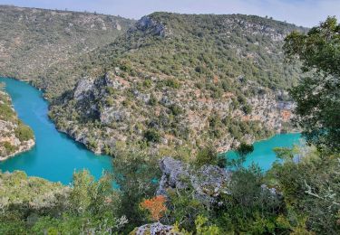
Randonnée V.T.T. de 19 km à découvrir à Provence-Alpes-Côte d'Azur, Alpes-de-Haute-Provence, Quinson. Cette randonnée est proposée par johan004.

Description

quinson - dir. montméyan - les 3 villa - GR99 - plateau malasoque - ravin ste maxime - retour la roquette - route de montmeyan - quinson.

Profil altimétrique

Points d'intérêt

Point d'intérêt Montmeyan - 1 - Photo
johan004
MONTMEYAN 
Point d'intérêt Montmeyan - 2 - Photo
johan004
MONTMEYAN 
Point d'intérêt Quinson - 3 - Photo
johan004
QUINSON 
Point d'intérêt Quinson - 4 - Photo
johan004
QUINSON 
Point d'intérêt Quinson - 5 - Photo
johan004
QUINSON 

Localisation

Pays :
France
Région :
Provence-Alpes-Côte d'Azur
Département/Province :
Alpes-de-Haute-Provence
Commune :
Quinson
Localité :
Unknown
Départ:(Dec)
Départ:(UTM)
261312 ; 4842795 (32T) N.

Commentaires

Veuillez vous connecter pour laisser un commentaire ou une note


Randonnées à proximité

Randonnée Marche Quinson - basses gorges du verdon - quinson - Photo
Marche
GUIDE
affinetataille

Marche

Moyen
(4)
Quinson, Provence-Alpes-Côte d'Azur, Alpes-de-Haute-Provence, France
12,7 km | 16,8 km-effort
2h 54min
Oui
Randonnée Marche Montagnac-Montpezat - coteau Chiron - Photo
Marche
aubr

Marche

Moyen
(1)
Montagnac-Montpezat, Provence-Alpes-Côte d'Azur, Alpes-de-Haute-Provence, France
5,5 km | 6,8 km-effort
1h 37min
Oui
Randonnée Marche Quinson - 2023-01-27 Quinson - Chemin de l'eau et retour rive droite  - Photo
Marche
GUIDE
Kargil

Marche

Difficile
Quinson, Provence-Alpes-Côte d'Azur, Alpes-de-Haute-Provence, France
17 km | 23 km-effort
4h 44min
Oui
Randonnée Marche Artignosc-sur-Verdon - 11-10-2022 Artignosc - Baudinard - Photo
Marche
GUIDE
Kargil

Marche

Difficile
Artignosc-sur-Verdon, Provence-Alpes-Côte d'Azur, Var, France
16,9 km | 22 km-effort
3h 42min
Oui
Randonnée Marche Quinson - 02/10/2022 Quinson - Sentier de la préhistoire - Source de Poiraque - Photo
Marche
GUIDE
Kargil

Marche

Moyen
Quinson, Provence-Alpes-Côte d'Azur, Alpes-de-Haute-Provence, France
11,4 km | 15,7 km-effort
3h 11min
Oui
Randonnée Marche Saint-Laurent-du-Verdon - 02-04-2022 Saint Laurent et son lac - Photo
Marche
GUIDE
Kargil

Marche

Facile
Saint-Laurent-du-Verdon, Provence-Alpes-Côte d'Azur, Alpes-de-Haute-Provence, France
7 km | 8,8 km-effort
2h 9min
Oui
Randonnée Marche Montmeyan - Verdon Sentier garde canal - Photo
Marche
GUIDE
R@ph

Marche

Difficile
Montmeyan, Provence-Alpes-Côte d'Azur, Var, France
9,1 km | 13,9 km-effort
3h 16min
Oui
Randonnée Marche Quinson - Chapelle Ste maxime, par les basses gorges du Verdon - Photo
Marche
jmheydorff

Marche

Très difficile
(2)
Quinson, Provence-Alpes-Côte d'Azur, Alpes-de-Haute-Provence, France
10,6 km | 15,9 km-effort
3h 48min
Oui
Randonnée Marche Quinson - Circuit Saint Maxime-basses gorges - Photo
Marche
vacances83

Marche

Difficile
(2)
Quinson, Provence-Alpes-Côte d'Azur, Alpes-de-Haute-Provence, France
9,3 km | 13,6 km-effort
Inconnu
Non


Fermer
Mes abonnements