Randonnée Marche Windstein - Windstein - Photo
 sgazaix
sgazaix

Utilisateur

© OpenStreetMap contributors
Longueur
Longueur
9,5 km
Altitude max
Altitude max
524 m
Dénivelé positif
Dénivelé positif
364 m
Km-Effort
Km-Effort  
14,4 km
Altitude min
Altitude min
316 m
Dénivelé négatif
Dénivelé négatif
364 m
Boucle
Boucle
Oui
Date de création :
2014-12-10 00:00:00.0
Dernière modification :
2014-12-10 00:00:00.0

(1 Avis)

Marche
Marche
3h09
Difficulté : Facile

Scannez ce code QR pour ouvrir la randonnée dans l'application SityTrail

Application GPS de randonnée GRATUITE

Logo SityTrail SityTrail

IGN / Instituts géographiques

Télécharger SityTrail sur l'App Store Télécharger SityTrail sur Google Play

Logo SityTrail SityTrail World

Le monde est à vous

Télécharger SityTrail sur l'App Store Télécharger SityTrail sur Google Play Télécharger SityTrail sur Huawei AppGallery

À propos

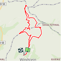
Randonnée Marche de 9,5 km à découvrir à Grand Est, Bas-Rhin, Windstein. Cette randonnée est proposée par sgazaix.

Description

cool

Profil altimétrique

Localisation

Pays :
France
Région :
Grand Est
Département/Province :
Bas-Rhin
Commune :
Windstein
Localité :
Unknown
Départ:(Dec)
Départ:(UTM)
403537 ; 5427994 (32U) N.

Commentaires

Veuillez vous connecter pour laisser un commentaire ou une note


Ne pas rater le départ qui se trouve à droite du chemin fermé par une barrière.


Randonnées à proximité

Randonnée Randonnée équestre Langensoultzbach - 2023-05-08 WE CVA Langensoultzbach Château Schoeneck - Photo
Randonnée équestre
GUIDE
holtzv

Randonnée équestre

Moyen
Langensoultzbach, Grand Est, Bas-Rhin, France
25 km | 34 km-effort
4h 25min
Oui
Randonnée Randonnée équestre Langensoultzbach - 2023-05-07 WE CVA Langensoultzbach Disteldorf - Photo
Randonnée équestre
GUIDE
holtzv

Randonnée équestre

Moyen
Langensoultzbach, Grand Est, Bas-Rhin, France
35 km | 48 km-effort
6h 18min
Oui
Randonnée Randonnée équestre Langensoultzbach - 2023-05-06 WE CVA Langensoultzbach Grand Wintersberg - Photo
Randonnée équestre
GUIDE
holtzv

Randonnée équestre

Moyen
Langensoultzbach, Grand Est, Bas-Rhin, France
31 km | 41 km-effort
5h 21min
Oui
Randonnée A pied Lembach - Anneau bleu - Photo
A pied
PRO

A pied

Facile
Lembach, Grand Est, Bas-Rhin, France
3,7 km | 5,4 km-effort
1h 14min
Oui
Randonnée A pied Niedersteinbach - Losange jaune - Photo
A pied
PRO

A pied

Facile
Niedersteinbach, Grand Est, Bas-Rhin, France
3,5 km | 5,1 km-effort
1h 9min
Non
Randonnée A pied Langensoultzbach - Croix jaune - Photo
A pied
PRO

A pied

Facile
Langensoultzbach, Grand Est, Bas-Rhin, France
8,1 km | 11,1 km-effort
2h 30min
Non
Randonnée A pied Wœrth - Rectangle rouge barré de blanc - Photo
A pied
PRO

A pied

Facile
Wœrth, Grand Est, Bas-Rhin, France
10,2 km | 12,9 km-effort
2h 56min
Non
Randonnée A pied Wœrth - Croix bleue - Photo
A pied
PRO

A pied

Facile
Wœrth, Grand Est, Bas-Rhin, France
14,1 km | 19,1 km-effort
4h 20min
Non
Randonnée A pied Obersteinbach - Anneau jaune - Photo
A pied
PRO

A pied

Facile
Obersteinbach, Grand Est, Bas-Rhin, France
3,8 km | 6,2 km-effort
1h 25min
Oui


Fermer
Mes abonnements