Randonnée Marche Chagey - Chagey - Bois de la Thure - Photo
 ballet
ballet

Utilisateur

© OpenStreetMap contributors
Longueur
Longueur
10,6 km
Altitude max
Altitude max
562 m
Dénivelé positif
Dénivelé positif
271 m
Km-Effort
Km-Effort  
14,2 km
Altitude min
Altitude min
338 m
Dénivelé négatif
Dénivelé négatif
270 m
Boucle
Boucle
Oui
Date de création :
2014-12-10 00:00:00.0
Dernière modification :
2014-12-10 00:00:00.0

(1 Avis)

Marche
Marche
2h35
Difficulté : Facile

Scannez ce code QR pour ouvrir la randonnée dans l'application SityTrail

Application GPS de randonnée GRATUITE

Logo SityTrail SityTrail

IGN / Instituts géographiques

Télécharger SityTrail sur l'App Store Télécharger SityTrail sur Google Play

Logo SityTrail SityTrail World

Le monde est à vous

Télécharger SityTrail sur l'App Store Télécharger SityTrail sur Google Play Télécharger SityTrail sur Huawei AppGallery

À propos

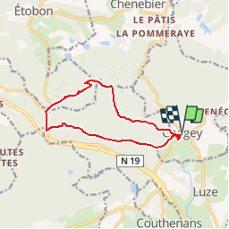
Randonnée Marche de 10,6 km à découvrir à Bourgogne-Franche-Comté, Haute-Saône, Chagey. Cette randonnée est proposée par ballet.

Profil altimétrique

Localisation

Pays :
France
Région :
Bourgogne-Franche-Comté
Département/Province :
Haute-Saône
Commune :
Chagey
Localité :
Unknown
Départ:(Dec)
Départ:(UTM)
329587 ; 5275643 (32T) N.

Commentaires

Veuillez vous connecter pour laisser un commentaire ou une note


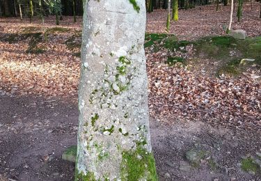
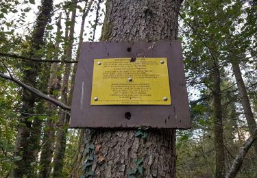
Rando sympa mais itinéraire tracé très incertain sur le côté nord de la colline du bois de la Thure (très escarpé)


Randonnées à proximité

Randonnée Marche Héricourt - La Pierre Plate - Héricourt - Photo
Marche
tracegps

Marche

Difficile
(3)
Héricourt, Bourgogne-Franche-Comté, Haute-Saône, France
12 km | 16,4 km-effort
3h 10min
Oui
Randonnée Marche Champey - champey - Photo
Marche
Fillatre

Marche

Difficile
(1)
Champey, Bourgogne-Franche-Comté, Haute-Saône, France
12,6 km | 16,5 km-effort
3h 37min
Oui
Randonnée Marche Mandrevillars - Echenans et son fort - Photo
Marche
Bart2015

Marche

Très difficile
Mandrevillars, Bourgogne-Franche-Comté, Haute-Saône, France
14,8 km | 19,6 km-effort
4h 27min
Oui
Randonnée Marche Châlonvillars - Châlonvillars - Fort du Salbert - Evette-Salbert - Photo
Marche
Bart2015

Marche

Difficile
(1)
Châlonvillars, Bourgogne-Franche-Comté, Haute-Saône, France
11 km | 15,8 km-effort
3h 36min
Oui
Randonnée V.T.T. Châlonvillars - Châlonvillars - Fort Giromagny en passant au milieu des étangs - Photo
V.T.T.
Bart2015

V.T.T.

Très difficile
Châlonvillars, Bourgogne-Franche-Comté, Haute-Saône, France
40 km | 51 km-effort
3h 31min
Oui
Randonnée V.T.T. Châlonvillars - Châlonvillars - Menhir - Mandrevillars - Fort Essert et du Salbert - Photo
V.T.T.
Bart2015

V.T.T.

Très difficile
Châlonvillars, Bourgogne-Franche-Comté, Haute-Saône, France
31 km | 42 km-effort
2h 53min
Oui
Randonnée Marche Châlonvillars - Châlonvillars - le mehnir - Mandrevillars - Photo
Marche
Bart2015

Marche

Moyen
Châlonvillars, Bourgogne-Franche-Comté, Haute-Saône, France
13,4 km | 17,1 km-effort
2h 39min
Oui
Randonnée Marche Châlonvillars - Châlonvillars - Mandrevillars - Photo
Marche
Bart2015

Marche

Facile
Châlonvillars, Bourgogne-Franche-Comté, Haute-Saône, France
9,5 km | 11,9 km-effort
1h 33min
Oui
Randonnée Marche Héricourt - Héricourt - Pierre Plate - Sentier de découverte - Photo
Marche
Bart2015

Marche

Moyen
Héricourt, Bourgogne-Franche-Comté, Haute-Saône, France
12,3 km | 16,7 km-effort
2h 20min
Oui


Fermer
Mes abonnements