Randonnée Marche Saint-Lormel - ARGUENON MARITIME - Photo
 JCLEF
JCLEF

Utilisateur

© OpenStreetMap contributors
Longueur
Longueur
13,8 km
Altitude max
Altitude max
49 m
Dénivelé positif
Dénivelé positif
194 m
Km-Effort
Km-Effort  
16,4 km
Altitude min
Altitude min
1 m
Dénivelé négatif
Dénivelé négatif
202 m
Boucle
Boucle
Non
Date de création :
2014-12-10 00:00:00.0
Dernière modification :
2014-12-10 00:00:00.0

(1 Avis)

Marche
Marche
4h00
Difficulté : Moyen

Scannez ce code QR pour ouvrir la randonnée dans l'application SityTrail

Application GPS de randonnée GRATUITE

Logo SityTrail SityTrail

IGN / Instituts géographiques

Télécharger SityTrail sur l'App Store Télécharger SityTrail sur Google Play

Logo SityTrail SityTrail World

Le monde est à vous

Télécharger SityTrail sur l'App Store Télécharger SityTrail sur Google Play Télécharger SityTrail sur Huawei AppGallery

À propos

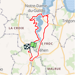
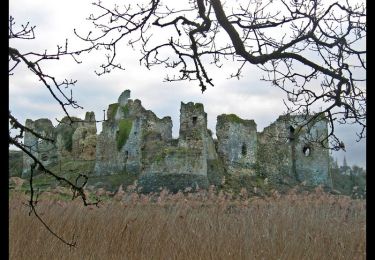
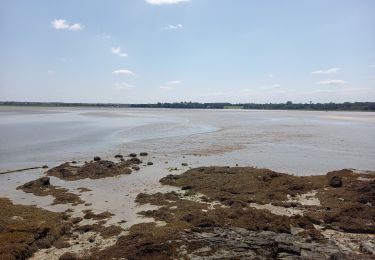
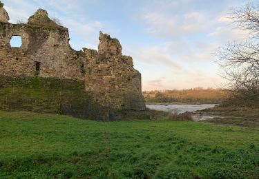
Randonnée Marche de 13,8 km à découvrir à Bretagne, Côtes-d'Armor, Saint-Lormel. Cette randonnée est proposée par JCLEF.

Profil altimétrique

Localisation

Pays :
France
Région :
Bretagne
Département/Province :
Côtes-d'Armor
Commune :
Saint-Lormel
Localité :
Unknown
Départ:(Dec)
Départ:(UTM)
556943 ; 5377196 (30U) N.

Commentaires

Veuillez vous connecter pour laisser un commentaire ou une note


Rando sans difficulté par temps sec, sinon prévoir une bonne paire de bottes (amont d'arguenon boueux sur rive gauche)


Randonnées à proximité

Randonnée A pied Beaussais-sur-Mer - Chemin des Dolmens - Photo
A pied
PRO

A pied

Facile
Beaussais-sur-Mer, Bretagne, Côtes-d'Armor, France
8,3 km | 9,5 km-effort
2h 8min
Oui
Randonnée A pied Plancoët - Eau et Nature - Photo
A pied
PRO

A pied

Facile
Plancoët, Bretagne, Côtes-d'Armor, France
11,2 km | 13,1 km-effort
2h 59min
Non
Randonnée Marche Créhen - St Jacut - île Ebihens - Photo
Marche
meunier.ph.

Marche

Facile
Créhen, Bretagne, Côtes-d'Armor, France
17,9 km | 21 km-effort
4h 15min
Oui
Randonnée Marche Créhen - Circuit de Créhen - Circuit bleu - Photo
Marche
tracegps

Marche

Moyen
Créhen, Bretagne, Côtes-d'Armor, France
11,1 km | 12,6 km-effort
2h 45min
Oui
Randonnée Marche Saint-Jacut-de-la-Mer - St Jacut de la Mer 7.7.23 - Photo
Marche
fredetpascale

Marche

Facile
Saint-Jacut-de-la-Mer, Bretagne, Côtes-d'Armor, France
10,2 km | 11,8 km-effort
3h 20min
Oui
Randonnée Course à pied Beaussais-sur-Mer - Les 4 vaux  - Photo
Course à pied
cps46

Course à pied

Facile
Beaussais-sur-Mer, Bretagne, Côtes-d'Armor, France
10,1 km | 12,1 km-effort
1h 30min
Non
Randonnée Marche Saint-Jacut-de-la-Mer - Pte de St Jacut - Photo
Marche
jeanvieve

Marche

Moyen
Saint-Jacut-de-la-Mer, Bretagne, Côtes-d'Armor, France
8,5 km | 9,6 km-effort
2h 10min
Oui
Randonnée Marche Saint-Cast-le-Guildo - penGuen  - Photo
Marche
Bernardroland

Marche

Moyen
Saint-Cast-le-Guildo, Bretagne, Côtes-d'Armor, France
9,7 km | 12,7 km-effort
3h 6min
Non
Randonnée Marche Créhen - la presqu'île de Saint Jacut depuis le château du Guildo  - Photo
Marche
selevrich

Marche

Facile
Créhen, Bretagne, Côtes-d'Armor, France
12,8 km | 14,7 km-effort
2h 53min
Oui


Fermer
Mes abonnements