Randonnée Marche Saint-Côme-et-Maruéjols - St Côme opidum de Mourressipe - Photo

St Côme opidum de Mourressipe

 CAMBON
CAMBON

Utilisateur

© OpenStreetMap contributors
Longueur
Longueur
4,9 km
Altitude max
Altitude max
180 m
Dénivelé positif
Dénivelé positif
106 m
Km-Effort
Km-Effort  
6,3 km
Altitude min
Altitude min
73 m
Dénivelé négatif
Dénivelé négatif
105 m
Boucle
Boucle
Oui
Date de création :
2014-12-10 00:00:00.0
Dernière modification :
2014-12-10 00:00:00.0

(0 Avis)

Marche
Marche
1h30
Difficulté : Facile

Scannez ce code QR pour ouvrir la randonnée dans l'application SityTrail

Application GPS de randonnée GRATUITE

Logo SityTrail SityTrail

IGN / Instituts géographiques

Télécharger SityTrail sur l'App Store Télécharger SityTrail sur Google Play

Logo SityTrail SityTrail World

Le monde est à vous

Télécharger SityTrail sur l'App Store Télécharger SityTrail sur Google Play Télécharger SityTrail sur Huawei AppGallery

À propos

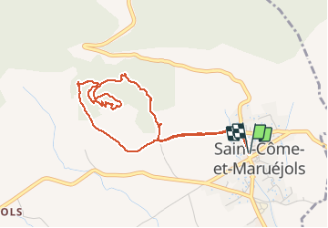
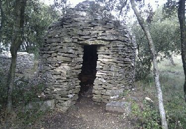
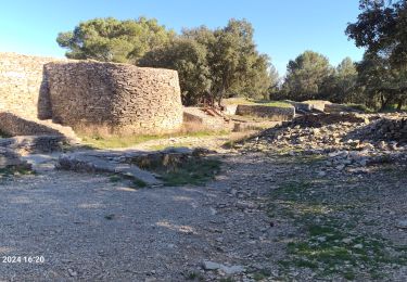
Randonnée Marche de 4,9 km à découvrir à Occitanie, Gard, Saint-Côme-et-Maruéjols. Cette randonnée est proposée par CAMBON.

Description

Des constructions à partir du IV
siècle av JC. Une vue magnifique sur la Vaunage. Le sentier traverse des bois de
chêne vert et blanc, arbousier
         

Profil altimétrique

Photos

Localisation

Pays :
France
Région :
Occitanie
Département/Province :
Gard
Commune :
Saint-Côme-et-Maruéjols
Localité :
Unknown
Départ:(Dec)
Départ:(UTM)
596657 ; 4853476 (31T) N.

Randonnées à proximité

Randonnée Marche Saint-Côme-et-Maruéjols - Saint Côme et Maruéjols - Photo
Marche
poisson1103

Marche

Très facile
(1)
Saint-Côme-et-Maruéjols, Occitanie, Gard, France
13,8 km | 17,2 km-effort
5h 30min
Oui
Randonnée Marche Langlade - Langlade - Voie-verte Fontaine - Photo
Marche
rando30129

Marche

Moyen
(1)
Langlade, Occitanie, Gard, France
7,8 km | 9,1 km-effort
2h 4min
Oui
Randonnée Marche Caveirac - chemin des capitelles St Roch  - Photo
Marche
kephas

Marche

Très facile
(1)
Caveirac, Occitanie, Gard, France
8,8 km | 10,7 km-effort
5h 20min
Oui
Randonnée V.T.T. Calvisson - Espace VTT-FFC Pays de Sommières n°7 - Les Châteaux du Sommiérois - Photo
V.T.T.
tracegps

V.T.T.

Difficile
(1)
Calvisson, Occitanie, Gard, France
42 km | 50 km-effort
3h 30min
Oui
Randonnée Marche Saint-Dionisy - Opidum de Nages - Photo
Marche
CAMBON

Marche

Facile
(2)
Saint-Dionisy, Occitanie, Gard, France
6,8 km | 9,4 km-effort
2h 0min
Oui
Randonnée Marche Langlade - NAGES ET SOLORGUES - LA GRAND COMBE - 16.5Km - 04h30 - Dénivelé 340 m - Photo
Marche
dansmabulle

Marche

Moyen
(1)
Langlade, Occitanie, Gard, France
16,7 km | 22 km-effort
4h 34min
Oui
Randonnée Marche Nages-et-Solorgues - nages-langlades - Photo
Marche
v.rabot

Marche

Moyen
Nages-et-Solorgues, Occitanie, Gard, France
14,8 km | 18,9 km-effort
5h 18min
Oui
Randonnée Marche Souvignargues - Saint Étienne d’Escattes - Photo
Marche
GUIDE
Roger Philippe Wallez

Marche

Très difficile
Souvignargues, Occitanie, Gard, France
16,9 km | 22 km-effort
4h 58min
Oui
Randonnée Marche Saint-Dionisy - Saint Dionisy -Oppidum - Nages - Photo
Marche
rando30129

Marche

Difficile
(1)
Saint-Dionisy, Occitanie, Gard, France
11 km | 15,7 km-effort
3h 9min
Oui


Fermer
Mes abonnements