Randonnée Autre activité Villeneuve-de-la-Raho - Villeneuve de la Raho - Photo
 perittel
perittel

Utilisateur

© OpenStreetMap contributors
Longueur
Longueur
16,1 km
Altitude max
Altitude max
40 m
Dénivelé positif
Dénivelé positif
118 m
Km-Effort
Km-Effort  
17,6 km
Altitude min
Altitude min
6 m
Dénivelé négatif
Dénivelé négatif
117 m
Boucle
Boucle
Oui
Date de création :
2014-12-10 00:00:00.0
Dernière modification :
2014-12-10 00:00:00.0

(0 Avis)

Autre activité
Autre activité
3h48
Difficulté : Facile

Scannez ce code QR pour ouvrir la randonnée dans l'application SityTrail

Application GPS de randonnée GRATUITE

Logo SityTrail SityTrail

IGN / Instituts géographiques

Télécharger SityTrail sur l'App Store Télécharger SityTrail sur Google Play

Logo SityTrail SityTrail World

Le monde est à vous

Télécharger SityTrail sur l'App Store Télécharger SityTrail sur Google Play Télécharger SityTrail sur Huawei AppGallery

À propos

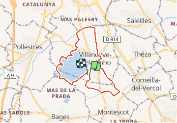
Randonnée Autre activité de 16,1 km à découvrir à Occitanie, Pyrénées-Orientales, Villeneuve-de-la-Raho. Cette randonnée est proposée par perittel.

Description


         Circuit de 16 km autour de Villeneuve de la Raho,proposé lors de la fête de la Randonnée 2013.

Profil altimétrique

Photos

Points d'intérêt

Point d'intérêt Villeneuve-de-la-Raho - Point 1 - Photo
perittel
VILLENEUVE-DE-LA-RAHO 

Localisation

Pays :
France
Région :
Occitanie
Département/Province :
Pyrénées-Orientales
Commune :
Villeneuve-de-la-Raho
Localité :
Unknown
Départ:(Dec)
Départ:(UTM)
492955 ; 4719349 (31T) N.

Randonnées à proximité

Randonnée Marche Montescot - 66 VILLENEUVE-DE-LA-RAHO grand tour du lac en Sens horaire  - Photo
Marche
jeff66

Marche

Facile
(1)
Montescot, Occitanie, Pyrénées-Orientales, France
6,7 km | 7,5 km-effort
1h 4min
Oui
Randonnée Marche Théza - 66 THEZA - CORNEILLA-DEL-VERCOL - Photo
Marche
jeff66

Marche

Facile
(2)
Théza, Occitanie, Pyrénées-Orientales, France
7 km | 7,5 km-effort
1h 8min
Oui
Randonnée Marche Saint-Jean-Lasseille - ST-JEAN-LASSEILLE 66 - terroirs des Aspres - Photo
Marche
jeff66

Marche

Facile
(1)
Saint-Jean-Lasseille, Occitanie, Pyrénées-Orientales, France
12,2 km | 14,3 km-effort
2h 6min
Oui
Randonnée Marche Villeneuve-de-la-Raho - 66 VILLENEUVE-DE-LA-RAHO - grand tour périphérique du lac par les lignes de crêtes  - Photo
Marche
jeff66

Marche

Facile
(2)
Villeneuve-de-la-Raho, Occitanie, Pyrénées-Orientales, France
10 km | 11,5 km-effort
1h 44min
Oui
Randonnée Marche Saleilles - 66 SALEILLES - St-NAZAIRE, entre FOSSEILLE et REART - Photo
Marche
jeff66

Marche

Facile
(1)
Saleilles, Occitanie, Pyrénées-Orientales, France
7,3 km | 7,7 km-effort
1h 8min
Oui
Randonnée Marche Corneilla-del-Vercol - thématique mo tescot du 18 02 2023 - Photo
Marche
66Gribouille83

Marche

Moyen
(1)
Corneilla-del-Vercol, Occitanie, Pyrénées-Orientales, France
8,9 km | 9,4 km-effort
1h 57min
Oui
Randonnée Marche Perpignan - Perpignan  - Photo
Marche
ombrabella

Marche

Très facile
Perpignan, Occitanie, Pyrénées-Orientales, France
18 km | 19,9 km-effort
2h 23min
Non
Randonnée Marche Perpignan - canal Perpignan  - Photo
Marche
Fildesir

Marche

Très facile
Perpignan, Occitanie, Pyrénées-Orientales, France
25 km | 27 km-effort
7h 29min
Non
Randonnée Marche Montescot - 66 VILLENEUVE-DE-LA-RAHO grand tour du lac en Sens horaire  - Photo
Marche
jeff66

Marche

Facile
Montescot, Occitanie, Pyrénées-Orientales, France
6,7 km | 7,5 km-effort
1h 4min
Oui


Fermer
Mes abonnements