Randonnée Marche Obernai - ginkgo 2913 - Photo
 dragonfr67
dragonfr67

Utilisateur

© OpenStreetMap contributors
Longueur
Longueur
14,6 km
Altitude max
Altitude max
771 m
Dénivelé positif
Dénivelé positif
604 m
Km-Effort
Km-Effort  
23 km
Altitude min
Altitude min
246 m
Dénivelé négatif
Dénivelé négatif
603 m
Boucle
Boucle
Oui
Date de création :
2019-04-26 07:30:26.677
Dernière modification :
2019-04-26 07:30:26.776

(0 Avis)

Marche
Marche
4h45
Difficulté : Moyen

Scannez ce code QR pour ouvrir la randonnée dans l'application SityTrail

Application GPS de randonnée GRATUITE

Logo SityTrail SityTrail

IGN / Instituts géographiques

Télécharger SityTrail sur l'App Store Télécharger SityTrail sur Google Play

Logo SityTrail SityTrail World

Le monde est à vous

Télécharger SityTrail sur l'App Store Télécharger SityTrail sur Google Play Télécharger SityTrail sur Huawei AppGallery

À propos

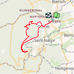
Randonnée Marche de 14,6 km à découvrir à Grand Est, Bas-Rhin, Obernai. Cette randonnée est proposée par dragonfr67.

Description

Rando annuelle 2013 du club de Qi Gong, très bel endroit pour faire du Qi Gong au pied du couvent.

Profil altimétrique

Localisation

Pays :
France
Région :
Grand Est
Département/Province :
Bas-Rhin
Commune :
Obernai
Localité :
Unknown
Départ:(Dec)
Départ:(UTM)
384226 ; 5368686 (32U) N.

Randonnées à proximité

Randonnée Marche Ottrott - Le circuit sud du Mur Païen - Photo
Marche
VacheKiri67

Marche

Facile
(2)
Ottrott, Grand Est, Bas-Rhin, France
4,9 km | 6,3 km-effort
1h 56min
Non
Randonnée Marche Ottrott - Le circuit nord du Mur Païen - Photo
Marche
VacheKiri67

Marche

Facile
(1)
Ottrott, Grand Est, Bas-Rhin, France
5,9 km | 8,5 km-effort
2h 4min
Non
Randonnée Marche Ottrott - Le Mont Sainte-Odile depuis Otrott - Photo
Marche
VacheKiri67

Marche

Moyen
(1)
Ottrott, Grand Est, Bas-Rhin, France
13 km | 20 km-effort
6h 18min
Oui
Randonnée Marche Ottrott - Montée vers le Mont Sainte-Odile - Photo
Marche
VacheKiri67

Marche

Difficile
(1)
Ottrott, Grand Est, Bas-Rhin, France
17,6 km | 26 km-effort
5h 52min
Oui
Randonnée Marche Ottrott - Le mur païen - Photo
Marche
VacheKiri67

Marche

Moyen
(4)
Ottrott, Grand Est, Bas-Rhin, France
10,5 km | 14,5 km-effort
4h 36min
Oui
Randonnée Marche Ottrott - Mur Paien complet - Photo
Marche
markrei

Marche

Moyen
(1)
Ottrott, Grand Est, Bas-Rhin, France
12 km | 16,4 km-effort
5h 25min
Oui
Randonnée Marche Obernai - Obernai gare - Mont St Odile - Photo
Marche
tracegps

Marche

Difficile
(2)
Obernai, Grand Est, Bas-Rhin, France
20 km | 29 km-effort
5h 0min
Oui
Randonnée V.T.T. Barr - Circuit des 3 Petits Ponts - Photo
V.T.T.
tracegps

V.T.T.

Difficile
(1)
Barr, Grand Est, Bas-Rhin, France
15,9 km | 22 km-effort
1h 19min
Oui
Randonnée V.T.T. Ottrott - Sainte-Odile East-Face - Photo
V.T.T.
tracegps

V.T.T.

Difficile
(1)
Ottrott, Grand Est, Bas-Rhin, France
24 km | 39 km-effort
3h 0min
Oui


Fermer
Mes abonnements