Randonnée Autre activité Pollestres - Pollestres-Elne - Photo
 perittel
perittel

Utilisateur

© OpenStreetMap contributors
Longueur
Longueur
27 km
Altitude max
Altitude max
60 m
Dénivelé positif
Dénivelé positif
215 m
Km-Effort
Km-Effort  
30 km
Altitude min
Altitude min
7 m
Dénivelé négatif
Dénivelé négatif
215 m
Boucle
Boucle
Oui
Date de création :
2014-12-10 00:00:00.0
Dernière modification :
2014-12-10 00:00:00.0

(0 Avis)

Autre activité
Autre activité
2h07
Difficulté : Facile

Scannez ce code QR pour ouvrir la randonnée dans l'application SityTrail

Application GPS de randonnée GRATUITE

Logo SityTrail SityTrail

IGN / Instituts géographiques

Télécharger SityTrail sur l'App Store Télécharger SityTrail sur Google Play

Logo SityTrail SityTrail World

Le monde est à vous

Télécharger SityTrail sur l'App Store Télécharger SityTrail sur Google Play Télécharger SityTrail sur Huawei AppGallery

À propos

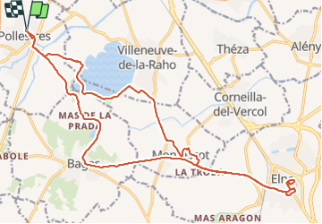
Randonnée Autre activité de 27 km à découvrir à Occitanie, Pyrénées-Orientales, Pollestres. Cette randonnée est proposée par perittel.

Description

Très beau circuit de ballade en vélo sans difficultés.

Profil altimétrique

Localisation

Pays :
France
Région :
Occitanie
Département/Province :
Pyrénées-Orientales
Commune :
Pollestres
Localité :
Unknown
Départ:(Dec)
Départ:(UTM)
489543 ; 4721264 (31T) N.

Randonnées à proximité

Randonnée Marche Montescot - 66 VILLENEUVE-DE-LA-RAHO grand tour du lac en Sens horaire  - Photo
Marche
jeff66

Marche

Facile
(1)
Montescot, Occitanie, Pyrénées-Orientales, France
6,7 km | 7,5 km-effort
1h 4min
Oui
Randonnée Marche Villeneuve-de-la-Raho - 66 VILLENEUVE-DE-LA-RAHO - grand tour périphérique du lac par les lignes de crêtes  - Photo
Marche
jeff66

Marche

Facile
(2)
Villeneuve-de-la-Raho, Occitanie, Pyrénées-Orientales, France
10 km | 11,5 km-effort
1h 44min
Oui
Randonnée V.T.T. Canohès - canohes - Photo
V.T.T.
haroldtheviking

V.T.T.

Moyen
(2)
Canohès, Occitanie, Pyrénées-Orientales, France
37 km | 44 km-effort
2h 12min
Oui
Randonnée Marche Perpignan - Perpignan  - Photo
Marche
ombrabella

Marche

Très facile
Perpignan, Occitanie, Pyrénées-Orientales, France
18 km | 19,9 km-effort
2h 23min
Non
Randonnée Marche Perpignan - canal Perpignan  - Photo
Marche
Fildesir

Marche

Très facile
Perpignan, Occitanie, Pyrénées-Orientales, France
25 km | 27 km-effort
7h 29min
Non
Randonnée Marche Perpignan - 66 PERPIGNAN, quartier MAV au Bas Vernet  - Photo
Marche
jeff66

Marche

Facile
Perpignan, Occitanie, Pyrénées-Orientales, France
10,7 km | 11,8 km-effort
1h 45min
Oui
Randonnée Marche Montescot - 66 VILLENEUVE-DE-LA-RAHO grand tour du lac en Sens horaire  - Photo
Marche
jeff66

Marche

Facile
Montescot, Occitanie, Pyrénées-Orientales, France
6,7 km | 7,5 km-effort
1h 4min
Oui
Randonnée Marche Perpignan - 66 PERPIGNAN - mas Balande, parc des sports, aviateurs, St Martin, MAV, Vertefeuille - Photo
Marche
jeff66

Marche

Facile
Perpignan, Occitanie, Pyrénées-Orientales, France
10,6 km | 11,6 km-effort
1h 52min
Oui
Randonnée Marche Perpignan - 66 PERPIGNAN - MAV aviateurs - ST MARTIN - palais des rois de Majorque - St Vicens, St Gaudérique - Photo
Marche
jeff66

Marche

Facile
Perpignan, Occitanie, Pyrénées-Orientales, France
8,6 km | 9,6 km-effort
1h 33min
Oui


Fermer
Mes abonnements