Randonnée Marche Ramonville-Saint-Agne - TT19 - Ramonville - Photo

Un grand voyage à pied, à travers Toulouse, pour le plaisir et pour la santé !

© OpenStreetMap contributors
Longueur
Longueur
9,4 km
Altitude max
Altitude max
165 m
Dénivelé positif
Dénivelé positif
72 m
Km-Effort
Km-Effort  
10,5 km
Altitude min
Altitude min
131 m
Dénivelé négatif
Dénivelé négatif
103 m
Boucle
Boucle
Non
Date de création :
2019-04-04 20:28:10.74
Dernière modification :
2019-08-19 16:06:05.7

(0 Avis)

Marche
Marche
2h21
Difficulté : Moyen

Scannez ce code QR pour ouvrir la randonnée dans l'application SityTrail

Application GPS de randonnée GRATUITE

Logo SityTrail SityTrail

IGN / Instituts géographiques

Télécharger SityTrail sur l'App Store Télécharger SityTrail sur Google Play

Logo SityTrail SityTrail World

Le monde est à vous

Télécharger SityTrail sur l'App Store Télécharger SityTrail sur Google Play Télécharger SityTrail sur Huawei AppGallery

À propos

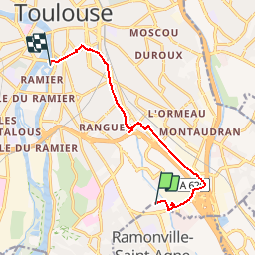
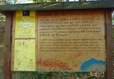
Randonnée Marche de 9,4 km à découvrir à Occitanie, Haute-Garonne, Ramonville-Saint-Agne. Cette randonnée est proposée par Transtoulousaine.

Description

Métro Ramonville - Halle de la Machine - Canal du Midi - Grand Rond - Jardin Royal

Profil altimétrique

Photos

Points d'intérêt

Point d'intérêt Ramonville-Saint-Agne - TT19 - départ Ramonville - Photo
Transtoulousaine
RAMONVILLE-SAINT-AGNE 

Localisation

Pays :
France
Région :
Occitanie
Département/Province :
Haute-Garonne
Commune :
Ramonville-Saint-Agne
Localité :
Unknown
Départ:(UTM)
376899 ; 4823760 (31T) N.

Randonnées à proximité

Randonnée V.T.C. Quint-Fonsegrives - Sainte-Foy d'Aigrefeuille Teulat Gragnague - Photo
V.T.C.
mipi31

V.T.C.

Moyen
Quint-Fonsegrives, Occitanie, Haute-Garonne, France
57 km | 69 km-effort
3h 52min
Oui
Randonnée Marche Castanet-Tolosan - castanet fait - Photo
Marche
pidjam

Marche

Très facile
(1)
Castanet-Tolosan, Occitanie, Haute-Garonne, France
10,5 km | 12,6 km-effort
2h 26min
Oui
Randonnée Marche Castanet-Tolosan - Boucle de Savignol  -  Castanet-Tolosan - Photo
Marche
tracegps

Marche

Moyen
Castanet-Tolosan, Occitanie, Haute-Garonne, France
10 km | 12,2 km-effort
2h 30min
Oui
Randonnée Marche Pechbusque - De Pechbusque à Auzeville Tolosane - Photo
Marche
tracegps

Marche

Moyen
Pechbusque, Occitanie, Haute-Garonne, France
11,2 km | 14,2 km-effort
3h 30min
Oui
Randonnée Marche Toulouse - TT22 Sauzelong - Photo
Marche

Marche

Facile
Toulouse, Occitanie, Haute-Garonne, France
5,8 km | 6,3 km-effort
1h 30min
Non
Randonnée Marche Castanet-Tolosan - TT22 Castanet-Tolosan - Photo
Marche

Marche

Moyen
Castanet-Tolosan, Occitanie, Haute-Garonne, France
17,2 km | 22 km-effort
5h 0min
Non
Randonnée Marche Toulouse - Toulouse : le Ramier  - Photo
Marche
richardsimopons

Marche

Toulouse, Occitanie, Haute-Garonne, France
8 km | 9,3 km-effort
1h 46min
Non
Randonnée V.T.C. Quint-Fonsegrives - Entre Saune  et Sausse - Photo
V.T.C.
mipi31

V.T.C.

Moyen
Quint-Fonsegrives, Occitanie, Haute-Garonne, France
51 km | 58 km-effort
3h 17min
Oui
Randonnée Marche Toulouse - TT19 - Garona - Photo
Marche

Marche

Facile
Toulouse, Occitanie, Haute-Garonne, France
6,8 km | 7,8 km-effort
1h 30min
Non


Fermer
Mes abonnements