Randonnée V.T.T. Castelnaud-la-Chapelle - 24-Castelnaud-20130727 - Photo
 Gus64
Gus64

Utilisateur

© OpenStreetMap contributors
Longueur
Longueur
40 km
Altitude max
Altitude max
237 m
Dénivelé positif
Dénivelé positif
1151 m
Km-Effort
Km-Effort  
55 km
Altitude min
Altitude min
63 m
Dénivelé négatif
Dénivelé négatif
1225 m
Boucle
Boucle
Non
Date de création :
2016-09-19 00:00:00.0
Dernière modification :
2016-09-19 00:00:00.0

(1 Avis)

V.T.T.
V.T.T.
3h40
Difficulté : Moyen

Scannez ce code QR pour ouvrir la randonnée dans l'application SityTrail

Application GPS de randonnée GRATUITE

Logo SityTrail SityTrail

IGN / Instituts géographiques

Télécharger SityTrail sur l'App Store Télécharger SityTrail sur Google Play

Logo SityTrail SityTrail World

Le monde est à vous

Télécharger SityTrail sur l'App Store Télécharger SityTrail sur Google Play Télécharger SityTrail sur Huawei AppGallery

À propos

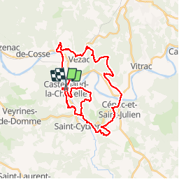
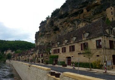
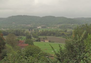
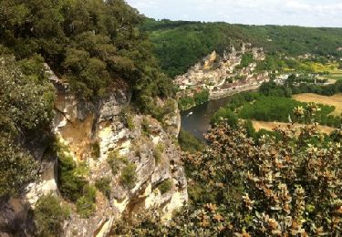
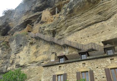
Randonnée V.T.T. de 40 km à découvrir à Nouvelle-Aquitaine, Dordogne, Castelnaud-la-Chapelle. Cette randonnée est proposée par Gus64.

Description

les bons singles du secteur

Profil altimétrique

Points d'intérêt

Point d'intérêt Castelnaud-la-Chapelle - single - Photo
Gus64
CASTELNAUD-LA-CHAPELLE 
Point d'intérêt Castelnaud-la-Chapelle - Single - Photo
Gus64
CASTELNAUD-LA-CHAPELLE 
Point d'intérêt Beynac-et-Cazenac - Single - Photo
Gus64
BEYNAC-ET-CAZENAC 
Point d'intérêt Vézac - Single - Photo
Gus64
VÉZAC 
Point d'intérêt La Roque-Gageac - Single - Photo
Gus64
LA ROQUE-GAGEAC 

Localisation

Pays :
France
Région :
Nouvelle-Aquitaine
Département/Province :
Dordogne
Commune :
Castelnaud-la-Chapelle
Localité :
Unknown
Départ:(Dec)
Départ:(UTM)
353686 ; 4963760 (31T) N.

Commentaires

Veuillez vous connecter pour laisser un commentaire ou une note


Randonnées à proximité

Randonnée Marche La Roque-Gageac - La Roque-Gageac - Cazenac - Photo
Marche
houbart

Marche

Difficile
(1)
La Roque-Gageac, Nouvelle-Aquitaine, Dordogne, France
12,9 km | 17,3 km-effort
3h 55min
Oui
Randonnée Marche Castelnaud-la-Chapelle - Castelnaud 14,5km - Photo
Marche
amelie14

Marche

Moyen
(1)
Castelnaud-la-Chapelle, Nouvelle-Aquitaine, Dordogne, France
14,3 km | 18,3 km-effort
3h 41min
Oui
Randonnée Marche La Roque-Gageac - boucle La Roque Gageac - Beynac - Photo
Marche
jcc24

Marche

Difficile
La Roque-Gageac, Nouvelle-Aquitaine, Dordogne, France
18,1 km | 27 km-effort
5h 7min
Oui
Randonnée Marche La Roque-Gageac - plus grand tour Roque Gageac - Photo
Marche
dedeyned

Marche

Très difficile
(1)
La Roque-Gageac, Nouvelle-Aquitaine, Dordogne, France
16,5 km | 25 km-effort
5h 11min
Oui
Randonnée Moteur Vézac - Jardin du château de Marquesac - Photo
Moteur
ohubau

Moteur

Très difficile
Vézac, Nouvelle-Aquitaine, Dordogne, France
5,3 km | 6,8 km-effort
4h 19min
Oui
Randonnée Marche La Roque-Gageac - La Roque Gageac - Photo
Marche
Ajax44

Marche

Moyen
La Roque-Gageac, Nouvelle-Aquitaine, Dordogne, France
9,7 km | 14,6 km-effort
3h 15min
Non
Randonnée Marche Castelnaud-la-Chapelle - Balade autour de Castelnaud la Chapelle - Photo
Marche
tracegps

Marche

Moyen
Castelnaud-la-Chapelle, Nouvelle-Aquitaine, Dordogne, France
13,5 km | 19 km-effort
3h 30min
Oui
Randonnée Marche Vézac - 2011-06-03 - 17h56m53 - Photo
Marche
infamerr

Marche

Très facile
(1)
Vézac, Nouvelle-Aquitaine, Dordogne, France
1,2 km | 1,8 km-effort
Inconnu
Oui
Randonnée Marche La Roque-Gageac - LA ROQUE GAGEAC BEYNAC MARQUESSAC - Photo
Marche
houbart

Marche

Difficile
La Roque-Gageac, Nouvelle-Aquitaine, Dordogne, France
12,4 km | 17 km-effort
3h 51min
Oui


Fermer
Mes abonnements