Randonnée Marche Barr - Barr (Mont-Sainte-Odile) 17 800m + 743m - Photo

Barr (Mont-Sainte-Odile) 17 800m + 743m

 DanielROLLET
DanielROLLET

Utilisateur

© OpenStreetMap contributors
Longueur
Longueur
17,8 km
Altitude max
Altitude max
816 m
Dénivelé positif
Dénivelé positif
743 m
Km-Effort
Km-Effort  
28 km
Altitude min
Altitude min
214 m
Dénivelé négatif
Dénivelé négatif
742 m
Boucle
Boucle
Oui
Date de création :
2019-06-08 08:48:51.012
Dernière modification :
2019-06-08 20:05:33.096

(0 Avis)

Marche
Marche
6h21
Difficulté : Difficile

Scannez ce code QR pour ouvrir la randonnée dans l'application SityTrail

Application GPS de randonnée GRATUITE

Logo SityTrail SityTrail

IGN / Instituts géographiques

Télécharger SityTrail sur l'App Store Télécharger SityTrail sur Google Play

Logo SityTrail SityTrail World

Le monde est à vous

Télécharger SityTrail sur l'App Store Télécharger SityTrail sur Google Play Télécharger SityTrail sur Huawei AppGallery

À propos

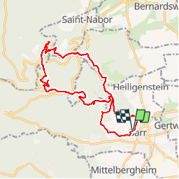
Randonnée Marche de 17,8 km à découvrir à Grand Est, Bas-Rhin, Barr. Cette randonnée est proposée par DanielROLLET.

Description

2019 06 08 - avec Marie - Beau temps mais vent frais
10h15 à 17h45 (compris 1h de pose au monastère)
Des planatges, en particulier pour ressortir de l'abri/table d'orientation Laegerwald

Profil altimétrique

Localisation

Pays :
France
Région :
Grand Est
Département/Province :
Bas-Rhin
Commune :
Barr
Localité :
Unknown
Départ:(UTM)
385071 ; 5362943 (32U) N.

Randonnées à proximité

Randonnée Marche Ottrott - Le circuit sud du Mur Païen - Photo
Marche
VacheKiri67

Marche

Facile
(2)
Ottrott, Grand Est, Bas-Rhin, France
4,9 km | 6,3 km-effort
1h 56min
Non
Randonnée Marche Ottrott - Le circuit nord du Mur Païen - Photo
Marche
VacheKiri67

Marche

Facile
(1)
Ottrott, Grand Est, Bas-Rhin, France
5,9 km | 8,5 km-effort
2h 4min
Non
Randonnée Marche Andlau - Depuis Andlau vers le village viticole de Mittelbergheim - Photo
Marche
VacheKiri67

Marche

Moyen
(1)
Andlau, Grand Est, Bas-Rhin, France
11,9 km | 15,9 km-effort
4h 3min
Oui
Randonnée Marche Ottrott - Le mur païen - Photo
Marche
VacheKiri67

Marche

Moyen
(4)
Ottrott, Grand Est, Bas-Rhin, France
10,5 km | 14,5 km-effort
4h 36min
Oui
Randonnée Marche Ottrott - Mur Paien complet - Photo
Marche
markrei

Marche

Moyen
(1)
Ottrott, Grand Est, Bas-Rhin, France
12 km | 16,4 km-effort
5h 25min
Oui
Randonnée V.T.T. Barr - Circuit des 3 Petits Ponts - Photo
V.T.T.
tracegps

V.T.T.

Difficile
(1)
Barr, Grand Est, Bas-Rhin, France
15,9 km | 22 km-effort
1h 19min
Oui
Randonnée Marche Reichsfeld - 2019-12-28 Marche Reichsfeld Ungersberg Gruckert - Photo
Marche
GUIDE
holtzv

Marche

Très facile
Reichsfeld, Grand Est, Bas-Rhin, France
12,2 km | 20 km-effort
3h 5min
Oui
Randonnée Marche Obernai - sentier des merveilles - Photo
Marche
semila

Marche

Difficile
(1)
Obernai, Grand Est, Bas-Rhin, France
11 km | 16,6 km-effort
4h 8min
Oui
Randonnée Marche Ottrott - 2013-12-29 Marche Mt Ste Odile Maennelstein Birkenfels - Photo
Marche
GUIDE
holtzv

Marche

Moyen
(1)
Ottrott, Grand Est, Bas-Rhin, France
10,8 km | 15,4 km-effort
3h 24min
Oui


Fermer
Mes abonnements