Randonnée V.T.C. Friesenheim - bac rhinau - Photo
 jackber
jackber

Utilisateur

© OpenStreetMap contributors
Longueur
Longueur
47 km
Altitude max
Altitude max
181 m
Dénivelé positif
Dénivelé positif
289 m
Km-Effort
Km-Effort  
51 km
Altitude min
Altitude min
153 m
Dénivelé négatif
Dénivelé négatif
290 m
Boucle
Boucle
Oui
Date de création :
2019-06-11 09:24:46.241
Dernière modification :
2019-06-11 19:04:44.027

(0 Avis)

V.T.C.
V.T.C.
6h26
Difficulté : Très facile

Scannez ce code QR pour ouvrir la randonnée dans l'application SityTrail

Application GPS de randonnée GRATUITE

Logo SityTrail SityTrail

IGN / Instituts géographiques

Télécharger SityTrail sur l'App Store Télécharger SityTrail sur Google Play

Logo SityTrail SityTrail World

Le monde est à vous

Télécharger SityTrail sur l'App Store Télécharger SityTrail sur Google Play Télécharger SityTrail sur Huawei AppGallery

À propos

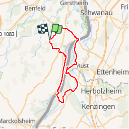
Randonnée V.T.C. de 47 km à découvrir à Grand Est, Bas-Rhin, Friesenheim. Cette randonnée est proposée par jackber.

Description

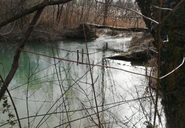
Attention aux zones inondables le long des bras du Rhin. Préférer les digues

Profil altimétrique

Photos

Localisation

Pays :
France
Région :
Grand Est
Département/Province :
Bas-Rhin
Commune :
Friesenheim
Localité :
Unknown
Départ:(UTM)
398905 ; 5351883 (32U) N.

Randonnées à proximité

Randonnée Marche Huttenheim - Trésor du Ried - Huttenheim - Photo
Marche
tracegps

Marche

Difficile
(1)
Huttenheim, Grand Est, Bas-Rhin, France
11,8 km | 12,8 km-effort
3h 15min
Oui
Randonnée Cheval Friesenheim - 2015-04-06 Balade des allées cavalieres - Photo
Cheval
GUIDE
holtzv

Cheval

Facile
(1)
Friesenheim, Grand Est, Bas-Rhin, France
32 km | 34 km-effort
5h 9min
Oui
Randonnée Cheval Herbsheim - Daubensand 01-11-2013 - Photo
Cheval
sophie.borjon

Cheval

Très facile
(1)
Herbsheim, Grand Est, Bas-Rhin, France
37 km | 40 km-effort
5h 24min
Oui
Randonnée Marche Rhinau - ile de rhinau2 - Photo
Marche
apa

Marche

Moyen
Rhinau, Grand Est, Bas-Rhin, France
10,4 km | 11,6 km-effort
2h 45min
Non
Randonnée Marche Rhinau - Île de Rhinau  - Photo
Marche
apa

Marche

Facile
Rhinau, Grand Est, Bas-Rhin, France
9,3 km | 10,5 km-effort
2h 39min
Oui
Randonnée Randonnée équestre Rossfeld - Boucle Rossfeld Huttenheim Chapelle Saint Materne - Photo
Randonnée équestre
GUIDE+

Randonnée équestre

Facile
Rossfeld, Grand Est, Bas-Rhin, France
24 km | 26 km-effort
1h 52min
Oui
Randonnée Marche Rhinau - centrale électrique de Rhinau - Photo
Marche
jo-da

Marche

Très facile
(1)
Rhinau, Grand Est, Bas-Rhin, France
4,1 km | 4,6 km-effort
2h 14min
Oui
Randonnée Cheval Friesenheim - 2013-06-05 Balade avec Laurent - Photo
Cheval
GUIDE
holtzv

Cheval

Très facile
Friesenheim, Grand Est, Bas-Rhin, France
11,9 km | 13,1 km-effort
1h 30min
Oui
Randonnée Cheval Rossfeld - 2013-05-09 Journee Allées cavalières g - Photo
Cheval
GUIDE
holtzv

Cheval

Facile
Rossfeld, Grand Est, Bas-Rhin, France
36 km | 38 km-effort
8h 16min
Oui


Fermer
Mes abonnements