Randonnée Marche Sentheim - Sentheim - Col du Schirm - Buissonniers - Kohlberg - Photo

Sentheim - Col du Schirm - Buissonniers - Kohlberg

 helmut68
helmut68

Utilisateur

© OpenStreetMap contributors
Longueur
Longueur
24 km
Altitude max
Altitude max
867 m
Dénivelé positif
Dénivelé positif
758 m
Km-Effort
Km-Effort  
34 km
Altitude min
Altitude min
353 m
Dénivelé négatif
Dénivelé négatif
759 m
Boucle
Boucle
Oui
Date de création :
2019-07-03 08:55:58.871
Dernière modification :
2019-07-05 19:42:44.3

(0 Avis)

Marche
Marche
5h53
Difficulté : Difficile

Scannez ce code QR pour ouvrir la randonnée dans l'application SityTrail

Application GPS de randonnée GRATUITE

Logo SityTrail SityTrail

IGN / Instituts géographiques

Télécharger SityTrail sur l'App Store Télécharger SityTrail sur Google Play

Logo SityTrail SityTrail World

Le monde est à vous

Télécharger SityTrail sur l'App Store Télécharger SityTrail sur Google Play Télécharger SityTrail sur Huawei AppGallery

À propos

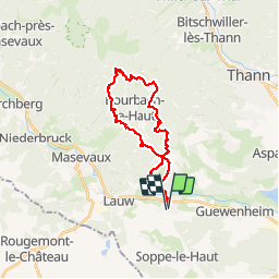
Randonnée Marche de 24 km à découvrir à Grand Est, Haut-Rhin, Sentheim. Cette randonnée est proposée par helmut68.

Description

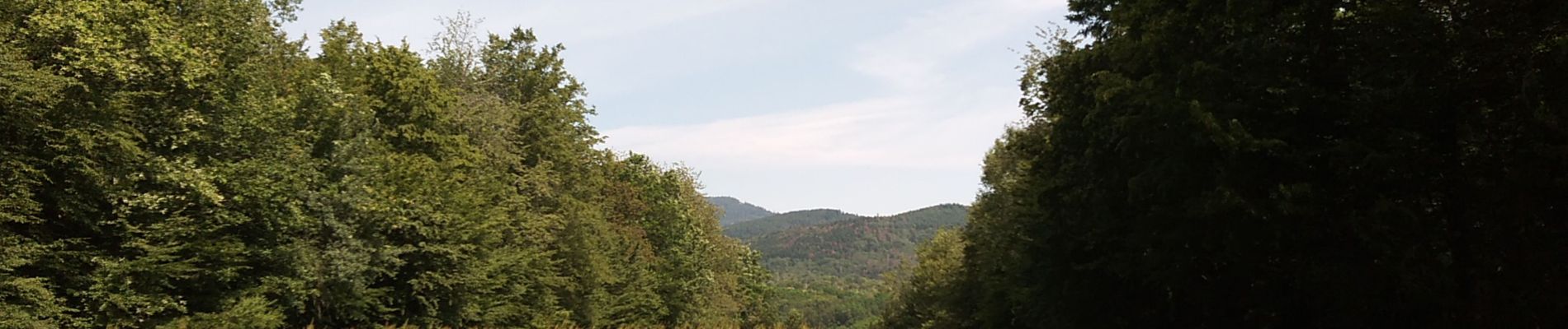
De la place de jeu de Sentheim, prendre la direction du Col de Schirm, par le sentier balisé rectangle " Rouge-Blanc-Rouge ". Ce sentier passe par le Bergwald, où vous découvrirez un magnifique point de vue sur la vallée de la Doller , le Sundgau , le Jura , les Alpes et la forêt Noire.
Arrivé au Col de Schirm , continuer sur le sentier rectangle " Rouge-Blanc-Rouge " jusqu'à la bifurcation vers le Bildbuche, balisée " Disque Bleu " jusqu'à la ferme auberge des Buissonnets ou vous pourrez vous restaurer ( fermée le mardi ).
A partir de là suivre le balisage "Croix - Rouge   " jusqu'au Col du Hundsruck , traverser la route Joffre puis emprunter le chemin qui mène jusqu'au monument des " Troupes de Chocs " , ensuite suivez le balisage " chemin du Kolberg " jusqu'à une bifurcation , emprunter le sentier balisé " Triangle Jaune " , puis le chemin , peu fréquenté, balisé par des grands anneaux blancs ( deux puis un) qui vous amènera jusqu'à l'entrée de Bourbach le Bas, au niveau de l'entreprise Burclé , rejoignez le parcours " VITÆ " de Bourbach le Bas ,puis revener à Sentheim par le balisage " Triangle     Jaune " qui repasse le Bergwald.
Très belle randonnée ,avec des points de vues  à couper le souffle... Attention à la partie entre le Kolberg et Bourbach le Bas qui n'est pas bien indiquée ( carte où GPS nécessaire ).

Profil altimétrique

Photos

28 photos au total. Cliquez sur une photo pour les afficher toutes dans la galerie.

Localisation

Pays :
France
Région :
Grand Est
Département/Province :
Haut-Rhin
Commune :
Sentheim
Localité :
Unknown
Départ:(UTM)
353935 ; 5290736 (32T) N.

Randonnées à proximité

Randonnée Marche Masevaux-Niederbruck - Masevaux - Rossberg par le belvédère du Fuchsfelsen - Photo
Marche
Bart2015

Marche

Moyen
(1)
Masevaux-Niederbruck, Grand Est, Haut-Rhin, France
19,9 km | 34 km-effort
4h 44min
Oui
Randonnée Marche Sentheim - Sentheim Rossberg - Photo
Marche
helmut68

Marche

Moyen
(1)
Sentheim, Grand Est, Haut-Rhin, France
27 km | 40 km-effort
6h 11min
Oui
Randonnée Marche Lauw - 2022-07-14 Marche Lauw Refuge CAF Baerenkopf - Photo
Marche
GUIDE
holtzv

Marche

Très difficile
Lauw, Grand Est, Haut-Rhin, France
18,4 km | 31 km-effort
5h 35min
Non
Randonnée A pied Sentheim - Sentier géologique du Wolfloch - Photo
A pied
PRO

A pied

Facile
Sentheim, Grand Est, Haut-Rhin, France
3,8 km | 4,8 km-effort
1h 5min
Non
Randonnée A pied Sentheim - Sentheim - Bergwald - Eichwald - Guevenheim - Sentheim - Photo
A pied
patrickbeyrath

A pied

Facile
(1)
Sentheim, Grand Est, Haut-Rhin, France
13,4 km | 16,6 km-effort
Inconnu
Oui
Randonnée Marche Sentheim - Knapphutte Saegenkopf Hütte - Photo
Marche
helmut68

Marche

Moyen
Sentheim, Grand Est, Haut-Rhin, France
13,8 km | 17,2 km-effort
5h 11min
Oui
Randonnée Marche Sentheim - Montori - Photo
Marche
helmut68

Marche

Moyen
Sentheim, Grand Est, Haut-Rhin, France
17,7 km | 24 km-effort
4h 47min
Oui
Randonnée V.T.T. Sentheim - AperoDioller - Photo
V.T.T.
helmut68

V.T.T.

Facile
Sentheim, Grand Est, Haut-Rhin, France
24 km | 27 km-effort
1h 23min
Oui
Randonnée Marche Sentheim - Baerenkopf  - Photo
Marche
helmut68

Marche

Difficile
Sentheim, Grand Est, Haut-Rhin, France
33 km | 49 km-effort
7h 0min
Oui


Fermer
Mes abonnements