Randonnée Marche Voulême - vouleme - Photo
 zette19
zette19

Utilisateur

© OpenStreetMap contributors
Longueur
Longueur
7,3 km
Altitude max
Altitude max
134 m
Dénivelé positif
Dénivelé positif
103 m
Km-Effort
Km-Effort  
8,7 km
Altitude min
Altitude min
90 m
Dénivelé négatif
Dénivelé négatif
112 m
Boucle
Boucle
Non
Date de création :
2019-08-09 07:43:28.234
Dernière modification :
2019-08-09 10:03:05.54

(0 Avis)

Marche
Marche
2h18
Difficulté : Très facile

Scannez ce code QR pour ouvrir la randonnée dans l'application SityTrail

Application GPS de randonnée GRATUITE

Logo SityTrail SityTrail

IGN / Instituts géographiques

Télécharger SityTrail sur l'App Store Télécharger SityTrail sur Google Play

Logo SityTrail SityTrail World

Le monde est à vous

Télécharger SityTrail sur l'App Store Télécharger SityTrail sur Google Play Télécharger SityTrail sur Huawei AppGallery

À propos

Randonnée Marche de 7,3 km à découvrir à Nouvelle-Aquitaine, Vienne, Voulême. Cette randonnée est proposée par zette19.

Description

randonnée les pieds dans l'eau

Profil altimétrique

Localisation

Pays :
France
Région :
Nouvelle-Aquitaine
Département/Province :
Vienne
Commune :
Voulême
Localité :
Unknown
Départ:(UTM)
285814 ; 5108550 (31T) N.

Randonnées à proximité

Randonnée Marche Taizé-Aizie - Taizé-Aizie - Photo
Marche
neoroll44

Marche

Moyen
Taizé-Aizie, Nouvelle-Aquitaine, Charente, France
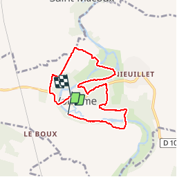
14,7 km | 17 km-effort
4h 0min
Oui
Randonnée Marche Les Adjots - Les Adjots - Photo
Marche
neoroll44

Marche

Moyen
Les Adjots, Nouvelle-Aquitaine, Charente, France
17,5 km | 19,7 km-effort
4h 20min
Oui
Randonnée Marche Saint-Macoux - St Macoux 7 km 2024 - Photo
Marche
Rembliere

Marche

Très facile
Saint-Macoux, Nouvelle-Aquitaine, Vienne, France
7,6 km | 8,7 km-effort
Inconnu
Oui
Randonnée Marche Saint-Macoux - St Macoux 2024 - Photo
Marche
Rembliere

Marche

Moyen
Saint-Macoux, Nouvelle-Aquitaine, Vienne, France
13,9 km | 15,4 km-effort
3h 29min
Oui
Randonnée Marche Saint-Macoux - St Macoux les gués de la Charente - Photo
Marche
Rembliere

Marche

Très difficile
Saint-Macoux, Nouvelle-Aquitaine, Vienne, France
22 km | 25 km-effort
5h 37min
Oui
Randonnée sport Saint-Macoux - 2023-08-31_10h43m07_Les_trois_saints - Photo
sport
Rembliere

sport

Très facile
Saint-Macoux, Nouvelle-Aquitaine, Vienne, France
13,5 km | 15,7 km-effort
Inconnu
Oui
Randonnée Marche Saint-Macoux - St Macoux Circuits des puits 2027 correction de 2022  - Photo
Marche
Rembliere

Marche

Difficile
Saint-Macoux, Nouvelle-Aquitaine, Vienne, France
14,4 km | 16,2 km-effort
3h 41min
Oui
Randonnée Marche Saint-Macoux - St Macoux le pont Grelet - Photo
Marche
Rembliere

Marche

Facile
Saint-Macoux, Nouvelle-Aquitaine, Vienne, France
6,9 km | 8,1 km-effort
1h 50min
Oui
Randonnée Marche Saint-Macoux - St Macoux 20 km  - Photo
Marche
Rembliere

Marche

Difficile
Saint-Macoux, Nouvelle-Aquitaine, Vienne, France
20 km | 23 km-effort
5h 11min
Oui


Fermer
Mes abonnements