Randonnée Marche Trois-Ponts - St Jacques 2019 - Photo
 ChristianLallemand
ChristianLallemand

Utilisateur

© OpenStreetMap contributors
Longueur
Longueur
21 km
Altitude max
Altitude max
575 m
Dénivelé positif
Dénivelé positif
524 m
Km-Effort
Km-Effort  
28 km
Altitude min
Altitude min
310 m
Dénivelé négatif
Dénivelé négatif
525 m
Boucle
Boucle
Oui
Date de création :
2019-08-14 13:06:00.467
Dernière modification :
2019-09-08 18:30:43.02

(0 Avis)

Marche
Marche
5h43
Difficulté : Moyen

Scannez ce code QR pour ouvrir la randonnée dans l'application SityTrail

Application GPS de randonnée GRATUITE

Logo SityTrail SityTrail

IGN / Instituts géographiques

Télécharger SityTrail sur l'App Store Télécharger SityTrail sur Google Play

Logo SityTrail SityTrail World

Le monde est à vous

Télécharger SityTrail sur l'App Store Télécharger SityTrail sur Google Play Télécharger SityTrail sur Huawei AppGallery

À propos

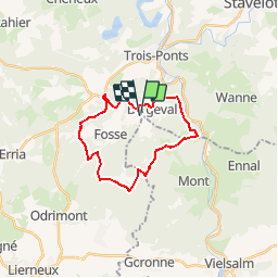
Randonnée Marche de 21 km à découvrir à Wallonie, Liège, Trois-Ponts. Cette randonnée est proposée par ChristianLallemand.

Profil altimétrique

Localisation

Pays :
Belgique
Région :
Wallonie
Département/Province :
Liège
Commune :
Trois-Ponts
Localité :
Fosse
Départ:(UTM)
703501 ; 5581277 (31U) N.

Randonnées à proximité

Randonnée Marche Trois-Ponts - RB-Lg-29_Wanne - Photo
Marche
PRO

Marche

Très difficile
(5)
Trois-Ponts, Wallonie, Liège, Belgique
22 km | 29 km-effort
6h 9min
Oui
Randonnée Marche Trois-Ponts - RB-Lg-27_Trois-Ponts - Photo
Marche
PRO

Marche

Très difficile
(7)
Trois-Ponts, Wallonie, Liège, Belgique
23 km | 33 km-effort
6h 58min
Oui
Randonnée Marche Stavelot - Stavelot  - Photo
Marche
GUIDE
mumu.larandonneuse

Marche

Difficile
(3)
Stavelot, Wallonie, Liège, Belgique
18,8 km | 26 km-effort
5h 53min
Non
Randonnée Marche Trois-Ponts - RB-Lg-29_Wanne_via-racc-2 - Photo
Marche
PRO

Marche

Très difficile
(3)
Trois-Ponts, Wallonie, Liège, Belgique
14,2 km | 19,2 km-effort
4h 21min
Oui
Randonnée Marche Trois-Ponts - RB-Lg-27_Trois-Ponts_via-racc - Photo
Marche
PRO

Marche

Très difficile
(1)
Trois-Ponts, Wallonie, Liège, Belgique
17 km | 25 km-effort
5h 12min
Oui
Randonnée Marche Lierneux - RB-Lg-25_Arbrefontaine_via-racc-2 - Photo
Marche
PRO

Marche

Difficile
(3)
Lierneux, Wallonie, Liège, Belgique
16 km | 21 km-effort
4h 29min
Oui
Randonnée Marche Lierneux - RB-Lg-25_Arbrefontaine - Photo
Marche
PRO

Marche

Très difficile
(4)
Lierneux, Wallonie, Liège, Belgique
23 km | 31 km-effort
6h 31min
Oui
Randonnée Marche Stavelot - Chemin des Sources |étape n°3  STAVELOT – HOCKAI - Photo
Marche
PRO

Marche

Très difficile
(1)
Stavelot, Wallonie, Liège, Belgique
19 km | 25 km-effort
5h 45min
Non
Randonnée Marche Stoumont - Monceau Cheneux barrage sup.Coo  - Photo
Marche
pqa621@gmail.com

Marche

Très facile
(2)
Stoumont, Wallonie, Liège, Belgique
7 km | 10,7 km-effort
1h 51min
Oui


Fermer
Mes abonnements