Randonnée Vélo Saint-Gilles-Waes - VlaanderenFietsland_route - Photo
 dkuypp
dkuypp

Utilisateur

© OpenStreetMap contributors
Longueur
Longueur
29 km
Altitude max
Altitude max
9 m
Dénivelé positif
Dénivelé positif
88 m
Km-Effort
Km-Effort  
30 km
Altitude min
Altitude min
-4 m
Dénivelé négatif
Dénivelé négatif
88 m
Boucle
Boucle
Oui
Date de création :
2019-08-21 14:37:13.402
Dernière modification :
2019-08-21 14:40:53.63

(0 Avis)

Vélo
Vélo
--
Difficulté : Très facile

Scannez ce code QR pour ouvrir la randonnée dans l'application SityTrail

Application GPS de randonnée GRATUITE

Logo SityTrail SityTrail

IGN / Instituts géographiques

Télécharger SityTrail sur l'App Store Télécharger SityTrail sur Google Play

Logo SityTrail SityTrail World

Le monde est à vous

Télécharger SityTrail sur l'App Store Télécharger SityTrail sur Google Play Télécharger SityTrail sur Huawei AppGallery

À propos

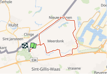
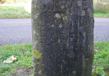
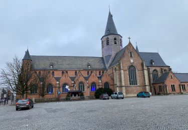
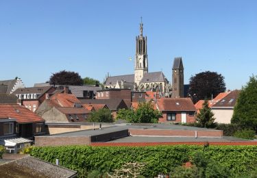
Randonnée Vélo de 29 km à découvrir à Flandre, Flandre orientale, Saint-Gilles-Waes. Cette randonnée est proposée par dkuypp.

Profil altimétrique

Points d'intérêt

Point d'intérêt Saint-Gilles-Waes - 80 - Photo
dkuypp
SAINT-GILLES-WAES 
Point d'intérêt Saint-Gilles-Waes - 53 - Photo
dkuypp
SAINT-GILLES-WAES 
Point d'intérêt Saint-Gilles-Waes - 73 - Photo
dkuypp
SAINT-GILLES-WAES 
Point d'intérêt Saint-Gilles-Waes - 10 - Photo
dkuypp
SAINT-GILLES-WAES 
Point d'intérêt Hulst - 60 - Photo
dkuypp
HULST 
Point d'intérêt Beveren - 12 - Photo
dkuypp
BEVEREN 
Point d'intérêt Beveren - 67 - Photo
dkuypp
BEVEREN 
Point d'intérêt Beveren - 69 - Photo
dkuypp
BEVEREN 
Point d'intérêt Saint-Gilles-Waes - 70 - Photo
dkuypp
SAINT-GILLES-WAES 
Point d'intérêt Saint-Gilles-Waes - 75 - Photo
dkuypp
SAINT-GILLES-WAES 
Point d'intérêt Saint-Gilles-Waes - 53 - Photo
dkuypp
SAINT-GILLES-WAES 
Point d'intérêt Saint-Gilles-Waes - 80 - Photo
dkuypp
SAINT-GILLES-WAES 

Localisation

Pays :
Belgique
Région :
Flandre
Département/Province :
Flandre orientale
Commune :
Saint-Gilles-Waes
Localité :
Sint-Gillis-Waas
Départ:(UTM)
576080 ; 5677377 (31U) N.

Randonnées à proximité

Randonnée A pied Hulst - Tweelandenroute - Photo
A pied
PRO

A pied

Facile
Hulst, Zélande, Inconnu, Pays-Bas
9,6 km | 10,2 km-effort
2h 19min
Oui
Randonnée A pied Stekene - Stropersbosroute - Lus 2 - Photo
A pied
PRO

A pied

Facile
Stekene, Flandre, Flandre orientale, Belgique
4,2 km | 4,6 km-effort
1h 3min
Oui
Randonnée A pied Stekene - Stropersbosroute - Lus 1 - Photo
A pied
PRO

A pied

Facile
Stekene, Flandre, Flandre orientale, Belgique
4,1 km | 4,5 km-effort
1h 1min
Oui
Randonnée Marche Saint-Gilles-Waes - De Klinge 21,9 km - Photo
Marche
GUIDE
rvapeldo

Marche

Moyen
Saint-Gilles-Waes, Flandre, Flandre orientale, Belgique
22 km | 24 km-effort
5h 14min
Oui
Randonnée A pied Stekene - Groene Puttenroute - Photo
A pied
PRO

A pied

Facile
Stekene, Flandre, Flandre orientale, Belgique
7 km | 7,8 km-effort
1h 46min
Oui
Randonnée Marche Stekene - Stekene 24 km - Photo
Marche
GUIDE
rvapeldo

Marche

Moyen
Stekene, Flandre, Flandre orientale, Belgique
24 km | 26 km-effort
5h 33min
Oui
Randonnée Marche Hulst - hulst bos et rampart 9 km - Photo
Marche
GUIDE
rvapeldo

Marche

Très facile
Hulst, Zélande, Inconnu, Pays-Bas
9 km | 9,7 km-effort
2h 28min
Non
Randonnée Marche Saint-Gilles-Waes - Stropersbos - De Clinge (14,5km) (StepAway.be) - Photo
Marche
corry.vandenbroeke

Marche

Très facile
Saint-Gilles-Waes, Flandre, Flandre orientale, Belgique
14,7 km | 16,1 km-effort
3h 38min
Oui
Randonnée Marche Stekene - Kanaal van Stekene (5km) (StepAway.be) - Photo
Marche
corry.vandenbroeke

Marche

Très facile
Stekene, Flandre, Flandre orientale, Belgique
4,9 km | 5,1 km-effort
1h 9min
Oui


Fermer
Mes abonnements