Randonnée Marche Goldbach-Altenbach - Ch. Freundstein - FA Ostein - Photo

Ch. Freundstein - FA Ostein

 regisbodilis
regisbodilis

Utilisateur

© OpenStreetMap contributors
Longueur
Longueur
10 km
Altitude max
Altitude max
952 m
Dénivelé positif
Dénivelé positif
450 m
Km-Effort
Km-Effort  
16 km
Altitude min
Altitude min
626 m
Dénivelé négatif
Dénivelé négatif
452 m
Boucle
Boucle
Oui
Date de création :
2014-12-10 00:00:00.0
Dernière modification :
2014-12-10 00:00:00.0

(0 Avis)

Marche
Marche
4h00
Difficulté : Facile

Scannez ce code QR pour ouvrir la randonnée dans l'application SityTrail

Application GPS de randonnée GRATUITE

Logo SityTrail SityTrail

IGN / Instituts géographiques

Télécharger SityTrail sur l'App Store Télécharger SityTrail sur Google Play

Logo SityTrail SityTrail World

Le monde est à vous

Télécharger SityTrail sur l'App Store Télécharger SityTrail sur Google Play Télécharger SityTrail sur Huawei AppGallery

À propos

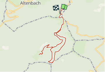
Randonnée Marche de 10 km à découvrir à Grand Est, Haut-Rhin, Goldbach-Altenbach. Cette randonnée est proposée par regisbodilis.

Description

Chateau - (rectangle rouge-blanc) FA Freundstein - chapelle Freundstein - FA Ostein - rocher d'Ostein - retour sur le chateau

Profil altimétrique

Localisation

Pays :
France
Région :
Grand Est
Département/Province :
Haut-Rhin
Commune :
Goldbach-Altenbach
Localité :
Unknown
Départ:(Dec)
Départ:(UTM)
359580 ; 5303393 (32T) N.

Randonnées à proximité

Randonnée Marche Soultz-Haut-Rhin - Hartmannswillerkopf - Circuit découverte - Photo
Marche
VacheKiri67

Marche

Facile
(1)
Soultz-Haut-Rhin, Grand Est, Haut-Rhin, France
3,6 km | 5,2 km-effort
1h 46min
Oui
Randonnée Marche Soultz-Haut-Rhin - Hartmannswillerkopf - Circuit anneau bleu - Photo
Marche
VacheKiri67

Marche

Moyen
(1)
Soultz-Haut-Rhin, Grand Est, Haut-Rhin, France
3,7 km | 5,9 km-effort
1h 37min
Oui
Randonnée Autre activité Steinbach - lac du ballon - Photo
Autre activité
rodabruna

Autre activité

Très facile
(1)
Steinbach, Grand Est, Haut-Rhin, France
33 km | 64 km-effort
5h 1min
Non
Randonnée A pied Goldbach-Altenbach - Firstacker - Willer sur Thur - Photo
A pied
PRO

A pied

Facile
Goldbach-Altenbach, Grand Est, Haut-Rhin, France
7,4 km | 9,6 km-effort
2h 11min
Non
Randonnée Trail Wattwiller - The History Ultra - Stage 1 - Photo
Trail
Olivier Houette

Trail

Très facile
(1)
Wattwiller, Grand Est, Haut-Rhin, France
28 km | 48 km-effort
Inconnu
Non
Randonnée A pied Bitschwiller-lès-Thann - Bitschwiller les Thann - Rehbrunnel - Abri du Becherkopf - Roche Albert - Photo
A pied
patrickbeyrath

A pied

Moyen
(1)
Bitschwiller-lès-Thann, Grand Est, Haut-Rhin, France
10,3 km | 16,4 km-effort
Inconnu
Oui
Randonnée Marche Soultz-Haut-Rhin - Rando Marcheurs..04/04_2025 - Photo
Marche
boubou68

Marche

Très difficile
Soultz-Haut-Rhin, Grand Est, Haut-Rhin, France
21 km | 35 km-effort
4h 42min
Oui
Randonnée Marche Jungholtz - Rando Retrouvailles...01/03/2024.par Jean Marc - Photo
Marche
boubou68

Marche

Très difficile
Jungholtz, Grand Est, Haut-Rhin, France
11,3 km | 19,2 km-effort
1h 35min
Oui
Randonnée Marche Soultz-Haut-Rhin - Mon tour des Vosges (4 jours) - Photo
Marche
annefrance70

Marche

Très difficile
Soultz-Haut-Rhin, Grand Est, Haut-Rhin, France
71 km | 113 km-effort
25h 38min
Oui


Fermer
Mes abonnements