Randonnée Marche Conthey - Mayens de Conthey - Croix de la châ - Photo

Mayens de Conthey - Croix de la châ

 duamerg
duamerg

Utilisateur

© OpenStreetMap contributors
Longueur
Longueur
15,1 km
Altitude max
Altitude max
2350 m
Dénivelé positif
Dénivelé positif
941 m
Km-Effort
Km-Effort  
28 km
Altitude min
Altitude min
1477 m
Dénivelé négatif
Dénivelé négatif
948 m
Boucle
Boucle
Oui
Date de création :
2014-12-11 00:00:00.0
Dernière modification :
2020-01-30 13:58:25.359

(0 Avis)

Marche
Marche
5h46
Difficulté : Facile

Scannez ce code QR pour ouvrir la randonnée dans l'application SityTrail

Application GPS de randonnée GRATUITE

Logo SityTrail SityTrail

IGN / Instituts géographiques

Télécharger SityTrail sur l'App Store Télécharger SityTrail sur Google Play

Logo SityTrail SityTrail World

Le monde est à vous

Télécharger SityTrail sur l'App Store Télécharger SityTrail sur Google Play Télécharger SityTrail sur Huawei AppGallery

À propos

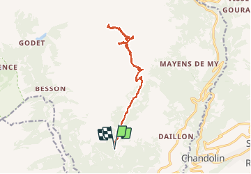
Randonnée Marche de 15,1 km à découvrir à Valais, Conthey, Conthey. Cette randonnée est proposée par duamerg.

Description

Prendre la route du col du Sanetsch jusqu'à Daillon. Monter aux Mayens de Conthey jusqu'à Codo et le départ de nombreuses courses. Laisser la voiture. Chemin bien balisé et facile par l'étang de trente pas jusqu'au col de la Croix de la Châ. Retour par le même chemin.

Profil altimétrique

Localisation

Pays :
Suisse
Région :
Valais
Département/Province :
Conthey
Commune :
Conthey
Localité :
Unknown
Départ:(Dec)
Départ:(UTM)
367045 ; 5123507 (32T) N.

Randonnées à proximité

Randonnée A pied Savièse - Bisse de Savièse (Torrent-Neuf) - Photo
A pied
PRO

A pied

Facile
Savièse, Valais, Sion, Suisse
4,5 km | 7,4 km-effort
1h 41min
Non
Randonnée A pied Ardon - Chemin des berges du Rhône - Photo
A pied
PRO

A pied

Facile
Ardon, Valais, Conthey, Suisse
4,4 km | 4,9 km-effort
1h 6min
Non
Randonnée A pied Conthey - Bisse de la Tsandra - Photo
A pied
PRO

A pied

Facile
Conthey, Valais, Conthey, Suisse
7,4 km | 10,5 km-effort
2h 23min
Non
Randonnée Marche Sion - Tour du Massif des Muverans - Photo
Marche
illustre

Marche

Très facile
Sion, Valais, Sion, Suisse
6,2 km | 14,1 km-effort
22h 11min
Non
Randonnée Autre activité Conthey - st_bg_conthey - Photo
Autre activité
GUIDE+

Autre activité

Très facile
Conthey, Valais, Conthey, Suisse
22 km | 42 km-effort
9h 21min
Non
Randonnée Marche Conthey - huetten_02 - Photo
Marche
GUIDE+

Marche

Très facile
Conthey, Valais, Conthey, Suisse
50 km | 102 km-effort
16h 52min
Oui
Randonnée Marche Conthey - Mombas-Dessus - pied du Mt Gond - Lodze - Besson - Photo
Marche
Leemans

Marche

Très difficile
Conthey, Valais, Conthey, Suisse
19,5 km | 38 km-effort
8h 42min
Oui
Randonnée Marche nordique Savièse - bisse torrent neuf - Photo
Marche nordique
ericf64

Marche nordique

Facile
Savièse, Valais, Sion, Suisse
9,1 km | 14,2 km-effort
3h 20min
Oui
Randonnée Marche Conthey - Lac Forcla - Photo
Marche
jipi2

Marche

Moyen
Conthey, Valais, Conthey, Suisse
16,8 km | 33 km-effort
8h 1min
Oui


Fermer
Mes abonnements