Randonnée Marche Audenge - Certes - Photo
 fga33
fga33

Utilisateur

© OpenStreetMap contributors
Longueur
Longueur
18,6 km
Altitude max
Altitude max
16 m
Dénivelé positif
Dénivelé positif
70 m
Km-Effort
Km-Effort  
19,5 km
Altitude min
Altitude min
-4 m
Dénivelé négatif
Dénivelé négatif
71 m
Boucle
Boucle
Oui
Date de création :
2014-12-10 00:00:00.0
Dernière modification :
2014-12-10 00:00:00.0

(1 Avis)

Marche
Marche
4h23
Difficulté : Moyen

Scannez ce code QR pour ouvrir la randonnée dans l'application SityTrail

Application GPS de randonnée GRATUITE

Logo SityTrail SityTrail

IGN / Instituts géographiques

Télécharger SityTrail sur l'App Store Télécharger SityTrail sur Google Play

Logo SityTrail SityTrail World

Le monde est à vous

Télécharger SityTrail sur l'App Store Télécharger SityTrail sur Google Play Télécharger SityTrail sur Huawei AppGallery

À propos

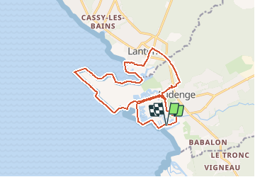
Randonnée Marche de 18,6 km à découvrir à Nouvelle-Aquitaine, Gironde, Audenge. Cette randonnée est proposée par fga33.

Description

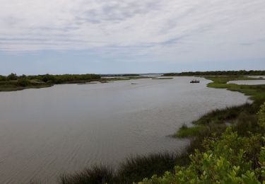
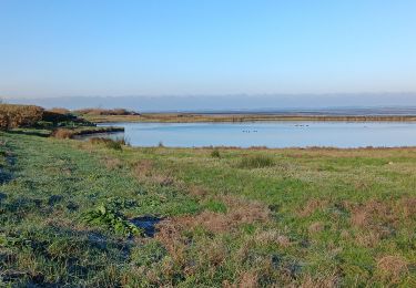
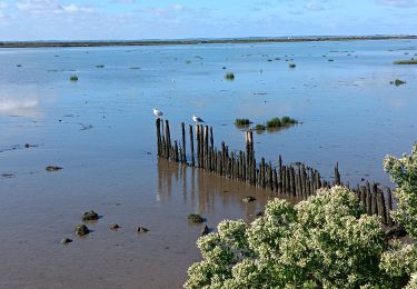
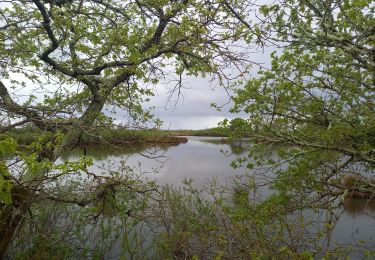
Domaine de Certes - Rando du littoral

Profil altimétrique

Localisation

Pays :
France
Région :
Nouvelle-Aquitaine
Département/Province :
Gironde
Commune :
Audenge
Localité :
Unknown
Départ:(Dec)
Départ:(UTM)
656578 ; 4949063 (30T) N.

Commentaires

Veuillez vous connecter pour laisser un commentaire ou une note


Belle randonnée mais un peu monotone


Randonnées à proximité

Randonnée Marche Gujan-Mestras - tour du parc ornithologique du technicien  - Photo
Marche
fomboudeau

Marche

Très facile
(1)
Gujan-Mestras, Nouvelle-Aquitaine, Gironde, France
8,6 km | 9 km-effort
2h 10min
Non
Randonnée V.T.T. Lanton - Port casse Pointe aux chevaux aux jacqués Port Ares - Photo
V.T.T.
kiavtt

V.T.T.

Moyen
(1)
Lanton, Nouvelle-Aquitaine, Gironde, France
50 km | 56 km-effort
3h 59min
Non
Randonnée Marche Lanton - Boucle Lanton - Photo
Marche
veneon

Marche

Très facile
(1)
Lanton, Nouvelle-Aquitaine, Gironde, France
11,5 km | 12,4 km-effort
2h 45min
Oui
Randonnée V.T.C. Le Teich - Le Teich - Photo
V.T.C.
Sigmut

V.T.C.

Facile
Le Teich, Nouvelle-Aquitaine, Gironde, France
13,5 km | 14,5 km-effort
1h 46min
Oui
Randonnée Marche Audenge - Grande boucle du domaine de Certes-Graveyron - Photo
Marche
Daniel.BRUN-PICARD

Marche

Facile
Audenge, Nouvelle-Aquitaine, Gironde, France
15,5 km | 16,4 km-effort
5h 0min
Oui
Randonnée Marche Audenge - Domaine de Certes - Photo
Marche
leaaudreymarie

Marche

Très facile
(2)
Audenge, Nouvelle-Aquitaine, Gironde, France
13,2 km | 14 km-effort
2h 54min
Oui
Randonnée Marche Le Teich - Parc Ornithologique du Teich  - Photo
Marche
Marc Launay

Marche

Moyen
Le Teich, Nouvelle-Aquitaine, Gironde, France
9 km | 9,4 km-effort
3h 7min
Oui
Randonnée Marche Lanton - PORT DE CASSIS  - Photo
Marche
Marc Launay

Marche

Moyen
Lanton, Nouvelle-Aquitaine, Gironde, France
8 km | 8,5 km-effort
2h 19min
Oui
Randonnée Marche Audenge - Tour de Graveyron 13.4.23 - Photo
Marche
fredetpascale

Marche

Très facile
Audenge, Nouvelle-Aquitaine, Gironde, France
5,1 km | 5,3 km-effort
1h 0min
Oui


Fermer
Mes abonnements