Randonnée Marche Anhée - Haut-le-Wastia Mai 1949 percee point de vue G - Photo

Haut-le-Wastia Mai 1949 percee point de vue G

 pjjrevrard
pjjrevrard

Utilisateur

© OpenStreetMap contributors
Longueur
Longueur
17,2 km
Altitude max
Altitude max
242 m
Dénivelé positif
Dénivelé positif
408 m
Km-Effort
Km-Effort  
23 km
Altitude min
Altitude min
86 m
Dénivelé négatif
Dénivelé négatif
408 m
Boucle
Boucle
Oui
Date de création :
2014-12-10 00:00:00.0
Dernière modification :
2014-12-10 00:00:00.0

(0 Avis)

Marche
Marche
4h27
Difficulté : Moyen

Scannez ce code QR pour ouvrir la randonnée dans l'application SityTrail

Application GPS de randonnée GRATUITE

Logo SityTrail SityTrail

IGN / Instituts géographiques

Télécharger SityTrail sur l'App Store Télécharger SityTrail sur Google Play

Logo SityTrail SityTrail World

Le monde est à vous

Télécharger SityTrail sur l'App Store Télécharger SityTrail sur Google Play Télécharger SityTrail sur Huawei AppGallery

À propos

Randonnée Marche de 17,2 km à découvrir à Wallonie, Namur, Anhée. Cette randonnée est proposée par pjjrevrard.

Profil altimétrique

Points d'intérêt

Point d'intérêt Anhée - Château de Senenne - Photo
pjjrevrard
Point d'intérêt Anhée - Blaockhaus du Pont d'Yvoir - Photo
pjjrevrard
Point d'intérêt Yvoir - Poilvache - Photo
pjjrevrard
YVOIR 
Point d'intérêt Yvoir - Barrage-écluse de Houx - Photo
pjjrevrard
Point d'intérêt Dinant - Vallon du Mont Noir - Photo
pjjrevrard
Point d'intérêt Anhée - Ferme de Grange - Photo
pjjrevrard
Point d'intérêt Anhée - Bois de Surinvaux - Photo
pjjrevrard
Point d'intérêt Onhaye - Ferme de Hontoir - Photo
pjjrevrard

Localisation

Pays :
Belgique
Région :
Wallonie
Département/Province :
Namur
Commune :
Anhée
Localité :
Haut-le-Wastia
Départ:(Dec)
Départ:(UTM)
631234 ; 5574257 (31U) N.

Randonnées à proximité

Randonnée Marche Anhée - RB-Na-22_Bioul_via-racc - Photo
Marche
PRO

Marche

Moyen
(5)
Anhée, Wallonie, Namur, Belgique
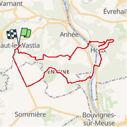
17,1 km | 22 km-effort
4h 42min
Oui
Randonnée Marche Anhée - RB-Na-22_Bioul - Photo
Marche
PRO

Marche

Moyen
(11)
Anhée, Wallonie, Namur, Belgique
21 km | 27 km-effort
5h 45min
Oui
Randonnée Marche Yvoir - RB-Na-03_Houx - Photo
Marche
PRO

Marche

Difficile
(10)
Yvoir, Wallonie, Namur, Belgique
22 km | 30 km-effort
7h 1min
Oui
Randonnée Marche Yvoir - RL-GG-38_Godinne_Dinant - Photo
Marche
PRO

Marche

Très difficile
(6)
Yvoir, Wallonie, Namur, Belgique
19,5 km | 27 km-effort
6h 13min
Non
Randonnée Marche Anhée - RF-Na-05 Annevoie, côté Jardins_Grande-boucle - Photo
Marche
PRO

Marche

Moyen
(11)
Anhée, Wallonie, Namur, Belgique
11,3 km | 14,5 km-effort
3h 6min
Oui
Randonnée Marche Anhée - RF-Na-05 Annevoie, côté Jardins_Petite-boucle - Photo
Marche
PRO

Marche

Facile
(7)
Anhée, Wallonie, Namur, Belgique
7,4 km | 10 km-effort
2h 7min
Oui
Randonnée Marche Onhaye - RB-Na-C2 La vallée du Flavion et le château moyenâgeux de Montaigle - complet - Photo
Marche
PRO

Marche

Très difficile
(2)
Onhaye, Wallonie, Namur, Belgique
20 km | 25 km-effort
5h 25min
Oui
Randonnée Marche Yvoir - RB-Na-21_Mont_via-racc - Photo
Marche
PRO

Marche

Moyen
(2)
Yvoir, Wallonie, Namur, Belgique
16,5 km | 22 km-effort
4h 45min
Oui
Randonnée Marche Dinant - Balade à Dinant - La Réserve Naturelle de Moniat - Photo
Marche
GUIDE
Desrumaux

Marche

Très facile
(1)
Dinant, Wallonie, Namur, Belgique
8,4 km | 10,9 km-effort
3h 54min
Oui


Fermer
Mes abonnements