Randonnée V.T.C. Waterloo - Waterloo-charleroi - Photo
 vanciaux
vanciaux

Utilisateur

© OpenStreetMap contributors
Longueur
Longueur
48 km
Altitude max
Altitude max
163 m
Dénivelé positif
Dénivelé positif
417 m
Km-Effort
Km-Effort  
54 km
Altitude min
Altitude min
88 m
Dénivelé négatif
Dénivelé négatif
431 m
Boucle
Boucle
Non
Date de création :
2020-07-14 15:41:35.713
Dernière modification :
2020-07-14 20:50:25.785

(0 Avis)

V.T.C.
V.T.C.
3h39
Difficulté : Moyen

Scannez ce code QR pour ouvrir la randonnée dans l'application SityTrail

Application GPS de randonnée GRATUITE

Logo SityTrail SityTrail

IGN / Instituts géographiques

Télécharger SityTrail sur l'App Store Télécharger SityTrail sur Google Play

Logo SityTrail SityTrail World

Le monde est à vous

Télécharger SityTrail sur l'App Store Télécharger SityTrail sur Google Play Télécharger SityTrail sur Huawei AppGallery

À propos

Randonnée V.T.C. de 48 km à découvrir à Wallonie, Brabant wallon, Waterloo. Cette randonnée est proposée par vanciaux.

Profil altimétrique

Localisation

Pays :
Belgique
Région :
Wallonie
Département/Province :
Brabant wallon
Commune :
Waterloo
Localité :
Waterloo
Départ:(UTM)
598539 ; 5620068 (31U) N.

Randonnées à proximité

Randonnée Marche Braine-l'Alleud - RB-Bw-13_Braine-l'Alleud - Photo
Marche
PRO

Marche

Très difficile
(5)
Braine-l'Alleud, Wallonie, Brabant wallon, Belgique
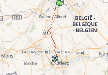
21 km | 27 km-effort
6h 2min
Oui
Randonnée Marche Braine-l'Alleud - RB-Bw-13_Braine-l'Alleud_via-racc-1-et-var - Photo
Marche
PRO

Marche

Difficile
(6)
Braine-l'Alleud, Wallonie, Brabant wallon, Belgique
14,8 km | 18,8 km-effort
4h 16min
Oui
Randonnée V.T.T. Braine-l'Alleud - O2bikers_58_Waterloo - Photo
V.T.T.
GUIDE+

V.T.T.

Très facile
(5)
Braine-l'Alleud, Wallonie, Brabant wallon, Belgique
30 km | 37 km-effort
4h 11min
Oui
Randonnée V.T.T. Waterloo - De Waterloo à la forêt de Soignes - Photo
V.T.T.
GUIDE
pascalou73

V.T.T.

Moyen
(1)
Waterloo, Wallonie, Brabant wallon, Belgique
39 km | 47 km-effort
3h 1min
Oui
Randonnée V.T.T. Rhode-Saint-Genèse - VTT des etangs - Photo
V.T.T.
GUIDE
pascalou73

V.T.T.

Moyen
(1)
Rhode-Saint-Genèse, Flandre, Brabant flamand, Belgique
31 km | 37 km-effort
2h 24min
Non
Randonnée Marche La Hulpe - La Hulpe - Circuit Natura 2000, des sites qui valent le détour - Bw02 - Photo
Marche
GUIDE+

Marche

Moyen
(5)
La Hulpe, Wallonie, Brabant wallon, Belgique
4,7 km | 5,9 km-effort
1h 16min
Non
Randonnée V.T.T. Rhode-Saint-Genèse - vtt de la forêt de Soigne - Photo
V.T.T.
GUIDE
pascalou73

V.T.T.

Facile
(1)
Rhode-Saint-Genèse, Flandre, Brabant flamand, Belgique
31 km | 38 km-effort
2h 27min
Oui
Randonnée Marche Rhode-Saint-Genèse - De Rhode Saint-Genèse à Groenendaal parl la forêt de Soignes - Photo
Marche
GUIDE
Desrumaux

Marche

Facile
(4)
Rhode-Saint-Genèse, Flandre, Brabant flamand, Belgique
10,3 km | 11,9 km-effort
2h 36min
Oui
Randonnée Marche Lasne - #240315 - Ohain Golf de Waterloo Marache**** - Photo
Marche
Randos Ouvertes

Marche

Moyen
(1)
Lasne, Wallonie, Brabant wallon, Belgique
6,3 km | 7,4 km-effort
1h 41min
Oui


Fermer
Mes abonnements