Randonnée Cyclotourisme Veuvey-sur-Ouche - 71 Bourgogne J8/8 - Photo
 ericf64
ericf64

Utilisateur

© OpenStreetMap contributors
Longueur
Longueur
57 km
Altitude max
Altitude max
599 m
Dénivelé positif
Dénivelé positif
608 m
Km-Effort
Km-Effort  
66 km
Altitude min
Altitude min
208 m
Dénivelé négatif
Dénivelé négatif
705 m
Boucle
Boucle
Non
Date de création :
2020-07-23 06:16:28.115
Dernière modification :
2020-07-24 14:40:18.34

(0 Avis)

Cyclotourisme
Cyclotourisme
7h00
Difficulté : Moyen

Scannez ce code QR pour ouvrir la randonnée dans l'application SityTrail

Application GPS de randonnée GRATUITE

Logo SityTrail SityTrail

IGN / Instituts géographiques

Télécharger SityTrail sur l'App Store Télécharger SityTrail sur Google Play

Logo SityTrail SityTrail World

Le monde est à vous

Télécharger SityTrail sur l'App Store Télécharger SityTrail sur Google Play Télécharger SityTrail sur Huawei AppGallery

À propos

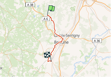
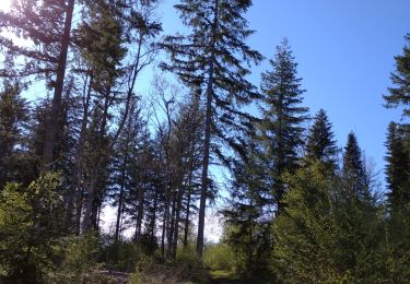
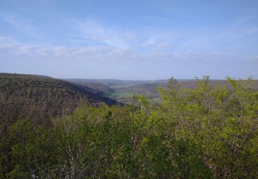
Randonnée Cyclotourisme de 57 km à découvrir à Bourgogne-Franche-Comté, Côte-d'Or, Veuvey-sur-Ouche. Cette randonnée est proposée par ericf64.

Description

de Veuvey sur Ouche à Chagny. en coupant par Bouilland, Beaune puis la voie des vignes

Profil altimétrique

Photos

Localisation

Pays :
France
Région :
Bourgogne-Franche-Comté
Département/Province :
Côte-d'Or
Commune :
Veuvey-sur-Ouche
Localité :
Unknown
Départ:(UTM)
629840 ; 5227524 (31T) N.

Randonnées à proximité

Randonnée Marche La Bussière-sur-Ouche - La Bête de l'Auxois - La Bussière sur Ouche - Photo
Marche
tracegps

Marche

Difficile
(1)
La Bussière-sur-Ouche, Bourgogne-Franche-Comté, Côte-d'Or, France
25 km | 33 km-effort
6h 0min
Oui
Randonnée Marche La Bussière-sur-Ouche - Pierre du druide , grotte de tebsima - Photo
Marche
eric.guyard21

Marche

Moyen
La Bussière-sur-Ouche, Bourgogne-Franche-Comté, Côte-d'Or, France
15,9 km | 23 km-effort
3h 32min
Oui
Randonnée Marche Antheuil - Saint JeandeBoeuf- Antheuil-Crugey-Labussièresur Ouche - Photo
Marche
mpstoop

Marche

Facile
Antheuil, Bourgogne-Franche-Comté, Côte-d'Or, France
27 km | 36 km-effort
8h 26min
Oui
Randonnée Marche Saint-Jean-de-Bœuf - Saint JeandeBoeuf-Gissey sur Ouche - Photo
Marche
mpstoop

Marche

Moyen
Saint-Jean-de-Bœuf, Bourgogne-Franche-Comté, Côte-d'Or, France
22 km | 31 km-effort
8h 5min
Oui
Randonnée Marche Détain-et-Bruant - blockhaus de Saint-Jean de Boeuf - Photo
Marche
mpstoop

Marche

Moyen
Détain-et-Bruant, Bourgogne-Franche-Comté, Côte-d'Or, France
11 km | 13,5 km-effort
1h 41min
Oui
Randonnée Marche Chaudenay-la-Ville - Chaudenay la ville  - Photo
Marche
eric.guyard21

Marche

Facile
Chaudenay-la-Ville, Bourgogne-Franche-Comté, Côte-d'Or, France
14,1 km | 17,9 km-effort
2h 37min
Oui
Randonnée Marche La Bussière-sur-Ouche - St Victor canal - Photo
Marche
eric.guyard21

Marche

Facile
La Bussière-sur-Ouche, Bourgogne-Franche-Comté, Côte-d'Or, France
12,8 km | 16,5 km-effort
2h 39min
Oui
Randonnée Marche La Bussière-sur-Ouche - D'une Rive à l'Autre - La Bussière sur Ouche - Photo
Marche
tracegps

Marche

Difficile
La Bussière-sur-Ouche, Bourgogne-Franche-Comté, Côte-d'Or, France
23 km | 32 km-effort
7h 0min
Oui
Randonnée Marche Colombier - Pont d ouche Pont d ouche par chaudenais la ville Crugey - Photo
Marche
Barbirotin21

Marche

Facile
Colombier, Bourgogne-Franche-Comté, Côte-d'Or, France
13,8 km | 17,7 km-effort
3h 33min
Oui


Fermer
Mes abonnements