Randonnée Marche Meyrargues - Meyrargues - Photo
 phidge
phidge

Utilisateur

© OpenStreetMap contributors
Longueur
Longueur
17,9 km
Altitude max
Altitude max
541 m
Dénivelé positif
Dénivelé positif
514 m
Km-Effort
Km-Effort  
25 km
Altitude min
Altitude min
244 m
Dénivelé négatif
Dénivelé négatif
514 m
Boucle
Boucle
Oui
Date de création :
2019-01-20 16:36:49.695
Dernière modification :
2019-01-20 16:36:49.736

(0 Avis)

Marche
Marche
6h10
Difficulté : Moyen

Scannez ce code QR pour ouvrir la randonnée dans l'application SityTrail

Application GPS de randonnée GRATUITE

Logo SityTrail SityTrail

IGN / Instituts géographiques

Télécharger SityTrail sur l'App Store Télécharger SityTrail sur Google Play

Logo SityTrail SityTrail World

Le monde est à vous

Télécharger SityTrail sur l'App Store Télécharger SityTrail sur Google Play Télécharger SityTrail sur Huawei AppGallery

À propos

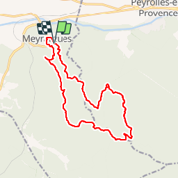
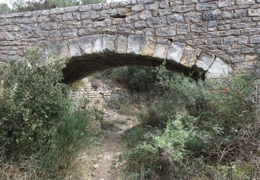
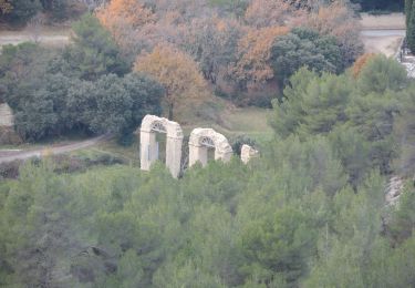
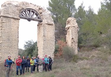
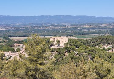
Randonnée Marche de 17,9 km à découvrir à Provence-Alpes-Côte d'Azur, Bouches-du-Rhône, Meyrargues. Cette randonnée est proposée par phidge.

Description

Rando du 13/02 avec José P2 T1
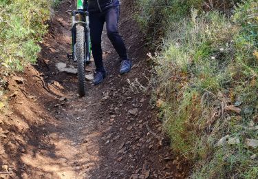
Profil altimétrique

Localisation

Pays :
France
Région :
Provence-Alpes-Côte d'Azur
Département/Province :
Bouches-du-Rhône
Commune :
Meyrargues
Localité :
Unknown
Départ:(Dec)
Départ:(UTM)
704293 ; 4834302 (31T) N.

Randonnées à proximité

Randonnée V.T.T. Venelles - Venelles version tête du Marquis - Photo
V.T.T.
samifly51

V.T.T.

Moyen
(1)
Venelles, Provence-Alpes-Côte d'Azur, Bouches-du-Rhône, France
25 km | 33 km-effort
3h 58min
Oui
Randonnée Marche Peyrolles-en-Provence - GB tour du  lac de Peyrolles  - Photo
Marche
Ghislaine Blanchet

Marche

Facile
(1)
Peyrolles-en-Provence, Provence-Alpes-Côte d'Azur, Bouches-du-Rhône, France
3,8 km | 4,2 km-effort
1h 23min
Non
Randonnée Marche Peyrolles-en-Provence - loubatas-Camp Chinois-retour par les vallons - Photo
Marche
Berpav

Marche

Très difficile
(2)
Peyrolles-en-Provence, Provence-Alpes-Côte d'Azur, Bouches-du-Rhône, France
15,3 km | 20 km-effort
3h 23min
Oui
Randonnée Marche Venelles - GB VENELLES  - Photo
Marche
Ghislaine Blanchet

Marche

Moyen
Venelles, Provence-Alpes-Côte d'Azur, Bouches-du-Rhône, France
5,2 km | 6,5 km-effort
1h 56min
Oui
Randonnée Marche Meyrargues - PF-Meyrargues - Les Calanques - Photo
Marche
MicDul

Marche

Facile
Meyrargues, Provence-Alpes-Côte d'Azur, Bouches-du-Rhône, France
14 km | 20 km-effort
4h 11min
Oui
Randonnée V.T.T. Venelles - venelles isa jeff - Photo
V.T.T.
jefflesmilles

V.T.T.

Moyen
Venelles, Provence-Alpes-Côte d'Azur, Bouches-du-Rhône, France
19,7 km | 25 km-effort
2h 40min
Oui
Randonnée Marche Meyrargues - 2023_01_15 galette ligoures AEP - Photo
Marche
Chri13

Marche

Facile
Meyrargues, Provence-Alpes-Côte d'Azur, Bouches-du-Rhône, France
14,6 km | 20 km-effort
7h 8min
Oui
Randonnée Marche Meyrargues - alentours de Meyrargues tracé bleu - Photo
Marche
GUIDE
amiral13

Marche

Très facile
Meyrargues, Provence-Alpes-Côte d'Azur, Bouches-du-Rhône, France
10,4 km | 14,4 km-effort
3h 20min
Oui
Randonnée Marche Peyrolles-en-Provence - Ancien canal du Verdon 1.5.22 - Photo
Marche
fredetpascale

Marche

Facile
Peyrolles-en-Provence, Provence-Alpes-Côte d'Azur, Bouches-du-Rhône, France
11,5 km | 14,9 km-effort
3h 40min
Oui


Fermer
Mes abonnements