Randonnée V.T.T. Guewenheim - Guewenheim_Vieux Thann - Photo

Guewenheim_Vieux Thann

 domi68440
domi68440

Utilisateur

© OpenStreetMap contributors
Longueur
Longueur
21 km
Altitude max
Altitude max
407 m
Dénivelé positif
Dénivelé positif
270 m
Km-Effort
Km-Effort  
25 km
Altitude min
Altitude min
298 m
Dénivelé négatif
Dénivelé négatif
271 m
Boucle
Boucle
Oui
Date de création :
2020-08-08 16:48:43.528
Dernière modification :
2020-08-09 15:52:10.156

(0 Avis)

V.T.T.
V.T.T.
1h40
Difficulté : Moyen

Scannez ce code QR pour ouvrir la randonnée dans l'application SityTrail

Application GPS de randonnée GRATUITE

Logo SityTrail SityTrail

IGN / Instituts géographiques

Télécharger SityTrail sur l'App Store Télécharger SityTrail sur Google Play

Logo SityTrail SityTrail World

Le monde est à vous

Télécharger SityTrail sur l'App Store Télécharger SityTrail sur Google Play Télécharger SityTrail sur Huawei AppGallery

À propos

Randonnée V.T.T. de 21 km à découvrir à Grand Est, Haut-Rhin, Guewenheim. Cette randonnée est proposée par domi68440.

Profil altimétrique

Localisation

Pays :
France
Région :
Grand Est
Département/Province :
Haut-Rhin
Commune :
Guewenheim
Localité :
Unknown
Départ:(UTM)
357527 ; 5290925 (32T) N.

Randonnées à proximité

Randonnée Marche Sentheim - Sentheim Rossberg - Photo
Marche
helmut68

Marche

Moyen
(1)
Sentheim, Grand Est, Haut-Rhin, France
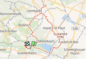
27 km | 40 km-effort
6h 11min
Oui
Randonnée A pied Sentheim - Sentier géologique du Wolfloch - Photo
A pied
PRO

A pied

Facile
Sentheim, Grand Est, Haut-Rhin, France
3,8 km | 4,8 km-effort
1h 5min
Non
Randonnée A pied Sentheim - Sentheim - Bergwald - Eichwald - Guevenheim - Sentheim - Photo
A pied
patrickbeyrath

A pied

Facile
(1)
Sentheim, Grand Est, Haut-Rhin, France
13,4 km | 16,6 km-effort
Inconnu
Oui
Randonnée Marche Sentheim - Knapphutte Saegenkopf Hütte - Photo
Marche
helmut68

Marche

Moyen
Sentheim, Grand Est, Haut-Rhin, France
13,8 km | 17,2 km-effort
5h 11min
Oui
Randonnée Marche Burnhaupt-le-Haut - Rando du 09/02/2024 par Alain...Pont d'Aspach - Photo
Marche
boubou68

Marche

Très difficile
Burnhaupt-le-Haut, Grand Est, Haut-Rhin, France
22 km | 27 km-effort
5h 12min
Oui
Randonnée Marche Sentheim - Montori - Photo
Marche
helmut68

Marche

Moyen
Sentheim, Grand Est, Haut-Rhin, France
17,7 km | 24 km-effort
4h 47min
Oui
Randonnée V.T.T. Sentheim - AperoDioller - Photo
V.T.T.
helmut68

V.T.T.

Facile
Sentheim, Grand Est, Haut-Rhin, France
24 km | 27 km-effort
1h 23min
Oui
Randonnée Marche Sentheim - Baerenkopf  - Photo
Marche
helmut68

Marche

Difficile
Sentheim, Grand Est, Haut-Rhin, France
33 km | 49 km-effort
7h 0min
Oui
Randonnée Marche Sentheim - Lac Seigneurie Soultzbach - Photo
Marche
helmut68

Marche

Facile
Sentheim, Grand Est, Haut-Rhin, France
10,9 km | 12,7 km-effort
3h 26min
Oui


Fermer
Mes abonnements