Randonnée V.T.T. Noble-Contrée -  - Photo
 maturin
maturin

Utilisateur

© OpenStreetMap contributors
Longueur
Longueur
144 km
Altitude max
Altitude max
2338 m
Dénivelé positif
Dénivelé positif
5441 m
Km-Effort
Km-Effort  
217 km
Altitude min
Altitude min
558 m
Dénivelé négatif
Dénivelé négatif
5495 m
Boucle
Boucle
Non
Date de création :
2014-12-11 00:00:00.0
Dernière modification :
2014-12-11 00:00:00.0

(0 Avis)

V.T.T.
V.T.T.
12h10
Difficulté : Inconnu

Scannez ce code QR pour ouvrir la randonnée dans l'application SityTrail

Application GPS de randonnée GRATUITE

Logo SityTrail SityTrail

IGN / Instituts géographiques

Télécharger SityTrail sur l'App Store Télécharger SityTrail sur Google Play

Logo SityTrail SityTrail World

Le monde est à vous

Télécharger SityTrail sur l'App Store Télécharger SityTrail sur Google Play Télécharger SityTrail sur Huawei AppGallery

À propos

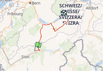
Randonnée V.T.T. de 144 km à découvrir à Valais, Sierre, Noble-Contrée. Cette randonnée est proposée par maturin.

Description

Départ de Veyras à 06h00, direction Leukerbad. Je prends la première montée en téléphérique pour la Gemmi (impossible de monter à vélo).

Descente depuis la Gemmi vers Kandersteg, en passant devant l''hôtel Schwachenbach. Ensuite, depuis Kandersteg, direction Spiez avant de tourner à droite à Reichenbach.

Continuer jusqu''à Interlaken et montée tranquille à Lauterbrunnen (déjà près de 100 km dans les jambes).

Bon, Lauterbruenne à Wengen en train à crémaillère (là aussi pas possible de monter à vélo...si ce n''est en le poussant). Arrivée ensuite à la Kleine Scheidegg (le point de départ vers la Junfraujoch).

Puis descente vers Grindelwald, avant d''attaquer la Grosse Scheidegg. De la-haut, descente finale vers Meiringen.... arrivée à 18h10.

Profil altimétrique

Points d'intérêt

Point d'intérêt Loèche-les-Bains - Leukerbad - Photo
maturin
LOÈCHE-LES-BAINS 
Point d'intérêt Lauterbrunnen - Lauterbrunnen - Photo
maturin
LAUTERBRUNNEN 
Point d'intérêt Lauterbrunnen - Kleine Scheidegg - Photo
maturin
LAUTERBRUNNEN 
Point d'intérêt Grindelwald - Grindelwald - Photo
maturin
GRINDELWALD 
Point d'intérêt Grindelwald - Grosse Scheidegg - Photo
maturin
GRINDELWALD 

Localisation

Pays :
Suisse
Région :
Valais
Département/Province :
Sierre
Commune :
Noble-Contrée
Localité :
Unknown
Départ:(Dec)
Départ:(UTM)
387466 ; 5128954 (32T) N.

Randonnées à proximité

Randonnée V.T.T. Crans-Montana - Tour des villages - Photo
V.T.T.
GUIDE+

V.T.T.

Très facile
(1)
Crans-Montana, Valais, Sierre, Suisse
23 km | 35 km-effort
3h 0min
Oui
Randonnée A pied Crans-Montana - Plaine Morte-Les Violettes - Photo
A pied
PRO

A pied

Facile
Crans-Montana, Valais, Sierre, Suisse
4,5 km | 11,5 km-effort
2h 36min
Non
Randonnée Marche Crans-Montana - Chemin du Vignoble - Itinéraire dégustation - Photo
Marche
GUIDE+

Marche

Très facile
Crans-Montana, Valais, Sierre, Suisse
7 km | 10,2 km-effort
2h 45min
Non
Randonnée Marche Sierre - Sierre à Chandolin - Photo
Marche
chandolin

Marche

Très facile
(1)
Sierre, Valais, Sierre, Suisse
11,5 km | 28 km-effort
7h 24min
Non
Randonnée V.T.T. Crans-Montana - Tour Hauts de Crans - Photo
V.T.T.
GUIDE+

V.T.T.

Très facile
Crans-Montana, Valais, Sierre, Suisse
7,8 km | 11,3 km-effort
1h 30min
Oui
Randonnée Marche Noble-Contrée - Bisse Neuf and Bisse de Varen - Photo
Marche
GUIDE+

Marche

Très facile
Noble-Contrée, Valais, Sierre, Suisse
10,5 km | 14,8 km-effort
3h 35min
Non
Randonnée Marche Lens - Cry d’Er - pointe Plaine Morte - Photo
Marche
jpksenicz

Marche

Très difficile
Lens, Valais, Sierre, Suisse
16,3 km | 30 km-effort
5h 8min
Non
Randonnée Marche Sierre - Promenade de Finges - Photo
Marche
GUIDE+

Marche

Très facile
Sierre, Valais, Sierre, Suisse
8,4 km | 10,4 km-effort
2h 29min
Non
Randonnée Marche Crans-Montana - Crans-Montana, Terre de foi - Photo
Marche
GUIDE+

Marche

Très facile
Crans-Montana, Valais, Sierre, Suisse
16,4 km | 26 km-effort
8h 0min
Oui


Fermer
Mes abonnements