Randonnée  Saint-Geoire-en-Valdaine - 2020-10-09_20h28m32_139582-n_32 - Photo
 les4elements
les4elements

Utilisateur

© OpenStreetMap contributors
Longueur
Longueur
9,2 km
Altitude max
Altitude max
586 m
Dénivelé positif
Dénivelé positif
209 m
Km-Effort
Km-Effort  
12 km
Altitude min
Altitude min
405 m
Dénivelé négatif
Dénivelé négatif
209 m
Boucle
Boucle
Oui
Date de création :
2020-10-09 18:28:32.666
Dernière modification :
2020-10-09 18:28:36.457

(0 Avis)


Scannez ce code QR pour ouvrir la randonnée dans l'application SityTrail

Application GPS de randonnée GRATUITE

Logo SityTrail SityTrail

IGN / Instituts géographiques

Télécharger SityTrail sur l'App Store Télécharger SityTrail sur Google Play

Logo SityTrail SityTrail World

Le monde est à vous

Télécharger SityTrail sur l'App Store Télécharger SityTrail sur Google Play Télécharger SityTrail sur Huawei AppGallery

À propos

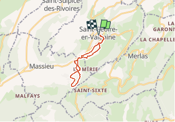
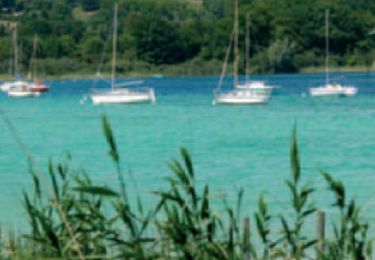
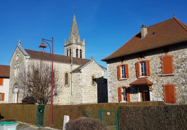
Randonnée de 9,2 km à découvrir à Auvergne-Rhône-Alpes, Isère, Saint-Geoire-en-Valdaine. Cette randonnée est proposée par les4elements.

Description

Converted from a KML file KML2GPX.COM

Profil altimétrique

Localisation

Pays :
France
Région :
Auvergne-Rhône-Alpes
Département/Province :
Isère
Commune :
Saint-Geoire-en-Valdaine
Localité :
Unknown
Départ:(UTM)
706114 ; 5036893 (31T) N.

Randonnées à proximité

Randonnée Marche Velanne - Boucle autour de sauge - Photo
Marche
choubaka77

Marche

Très facile
Velanne, Auvergne-Rhône-Alpes, Isère, France
5,7 km | 7,2 km-effort
1h 33min
Oui
Randonnée Marche Saint-Sulpice-des-Rivoires - st sulpice mt blanc - Photo
Marche
lmontbazon

Marche

Facile
Saint-Sulpice-des-Rivoires, Auvergne-Rhône-Alpes, Isère, France
9,7 km | 12,6 km-effort
2h 46min
Oui
Randonnée Marche Miribel-les-Échelles - Col des mille martyrs - Photo
Marche
crocau

Marche

Très facile
(1)
Miribel-les-Échelles, Auvergne-Rhône-Alpes, Isère, France
5,9 km | 8,2 km-effort
2h 42min
Non
Randonnée Marche Montferrat - Pays Voironnais - Circuit GPS de la Roselière - Photo
Marche
tracegps

Marche

Difficile
Montferrat, Auvergne-Rhône-Alpes, Isère, France
12 km | 16,6 km-effort
2h 45min
Oui
Randonnée V.T.T. Merlas - saint sixte - Photo
V.T.T.
les4elements

V.T.T.

Facile
Merlas, Auvergne-Rhône-Alpes, Isère, France
11,2 km | 18,4 km-effort
1h 44min
Non
Randonnée sport Saint-Geoire-en-Valdaine - SityTrail - 2020-10-09_20h28m32_139582-n_32 - Photo
sport
les4elements

sport

Très facile
Saint-Geoire-en-Valdaine, Auvergne-Rhône-Alpes, Isère, France
9,2 km | 12 km-effort
Inconnu
Oui
Randonnée Marche Merlas - merlas - Photo
Marche
phdriot

Marche

Très facile
Merlas, Auvergne-Rhône-Alpes, Isère, France
9,2 km | 13,6 km-effort
2h 31min
Oui
Randonnée sport Saint-Geoire-en-Valdaine - 2020-10-09_20h29m53_139598-n_34 - Photo
sport
les4elements

sport

Très facile
Saint-Geoire-en-Valdaine, Auvergne-Rhône-Alpes, Isère, France
25 km | 35 km-effort
Inconnu
Oui
Randonnée sport Saint-Geoire-en-Valdaine - 2020-10-09_20h29m41_139593-35 - Photo
sport
les4elements

sport

Très facile
Saint-Geoire-en-Valdaine, Auvergne-Rhône-Alpes, Isère, France
19,3 km | 28 km-effort
Inconnu
Oui


Fermer
Mes abonnements