Randonnée Marche Braine-l'Alleud - Ophain-Bois-Seigneur-Isaac - Photo
 luckybiker
luckybiker

Utilisateur

© OpenStreetMap contributors
Longueur
Longueur
11,6 km
Altitude max
Altitude max
152 m
Dénivelé positif
Dénivelé positif
151 m
Km-Effort
Km-Effort  
13,6 km
Altitude min
Altitude min
98 m
Dénivelé négatif
Dénivelé négatif
151 m
Boucle
Boucle
Oui
Date de création :
2021-02-04 19:51:39.478
Dernière modification :
2021-02-04 19:58:00.611

(0 Avis)

Marche
Marche
3h05
Difficulté : Difficile

Scannez ce code QR pour ouvrir la randonnée dans l'application SityTrail

Application GPS de randonnée GRATUITE

Logo SityTrail SityTrail

IGN / Instituts géographiques

Télécharger SityTrail sur l'App Store Télécharger SityTrail sur Google Play

Logo SityTrail SityTrail World

Le monde est à vous

Télécharger SityTrail sur l'App Store Télécharger SityTrail sur Google Play Télécharger SityTrail sur Huawei AppGallery

À propos

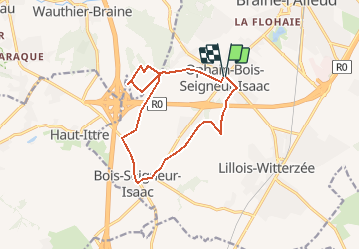
Randonnée Marche de 11,6 km à découvrir à Wallonie, Brabant wallon, Braine-l'Alleud. Cette randonnée est proposée par luckybiker.

Profil altimétrique

Points d'intérêt

Point d'intérêt Braine-l'Alleud - Eglise Ste-Aldegonde - Photo
luckybiker
BRAINE-L'ALLEUD 
Point d'intérêt Braine-l'Alleud - Abbaye de Nizelles - Photo
luckybiker
BRAINE-L'ALLEUD 
Point d'intérêt Braine-l'Alleud - Abbaye, chapelle, ferme et château de Bois-Seigneur-Isaac - Photo
luckybiker
Point d'intérêt Braine-l'Alleud - Chapelle des Belles Pierres - Photo
luckybiker

Localisation

Pays :
Belgique
Région :
Wallonie
Département/Province :
Brabant wallon
Commune :
Braine-l'Alleud
Localité :
Ophain-Bois-Seigneur-Isaac
Départ:(UTM)
595265 ; 5613551 (31U) N.

Randonnées à proximité

Randonnée Marche Braine-l'Alleud - RB-Bw-13_Braine-l'Alleud - Photo
Marche
PRO

Marche

Très difficile
(5)
Braine-l'Alleud, Wallonie, Brabant wallon, Belgique
21 km | 27 km-effort
6h 2min
Oui
Randonnée Marche Braine-l'Alleud - RB-Bw-13_Braine-l'Alleud_via-racc-1-et-var - Photo
Marche
PRO

Marche

Difficile
(6)
Braine-l'Alleud, Wallonie, Brabant wallon, Belgique
14,8 km | 18,8 km-effort
4h 16min
Oui
Randonnée V.T.T. Braine-l'Alleud - O2bikers_58_Waterloo - Photo
V.T.T.
GUIDE+

V.T.T.

Très facile
(5)
Braine-l'Alleud, Wallonie, Brabant wallon, Belgique
30 km | 37 km-effort
4h 11min
Oui
Randonnée V.T.T. Waterloo - De Waterloo à la forêt de Soignes - Photo
V.T.T.
GUIDE
pascalou73

V.T.T.

Moyen
(1)
Waterloo, Wallonie, Brabant wallon, Belgique
39 km | 47 km-effort
3h 1min
Oui
Randonnée Marche Hal - Balade dans le Bois de Halle - Photo
Marche
GUIDE
Desrumaux

Marche

Facile
(2)
Hal, Flandre, Brabant flamand, Belgique
8,6 km | 10,5 km-effort
2h 14min
Oui
Randonnée Marche Braine-l'Alleud - #221003 - Braine-l'Alleud, Timpe et Tard et Bois du Foriest, Parc et Lac du Paradis**** - Photo
Marche
Randos Ouvertes

Marche

Moyen
(1)
Braine-l'Alleud, Wallonie, Brabant wallon, Belgique
8,1 km | 9,8 km-effort
2h 13min
Oui
Randonnée Marche Braine-l'Alleud - Promenade 1815 - Photo
Marche
Waterloo Tourisme

Marche

Difficile
(3)
Braine-l'Alleud, Wallonie, Brabant wallon, Belgique
14,4 km | 16,7 km-effort
3h 39min
Oui
Randonnée Marche Hal - bois de halle hallerbos - Photo
Marche
Daniel Delhoute

Marche

Très facile
(1)
Hal, Flandre, Brabant flamand, Belgique
7,1 km | 8,6 km-effort
1h 35min
Oui
Randonnée Marche Braine-l'Alleud - BLA_0223 XL - Photo
Marche
calofrancis

Marche

Moyen
(1)
Braine-l'Alleud, Wallonie, Brabant wallon, Belgique
9,4 km | 10,8 km-effort
1h 57min
Oui


Fermer
Mes abonnements