


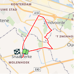
Snaaskerke Oostendse Polders Gistel - 11 km RT

wandelroutes
Utilisateur

Longueur
10,8 km

Altitude max
5 m

Dénivelé positif
36 m
Km-Effort
11,3 km

Altitude min
-3 m

Dénivelé négatif
36 m
Boucle
Oui
Date de création :
2014-12-10 00:00:00.0
Dernière modification :
2014-12-10 00:00:00.0
--
Difficulté : Inconnu

Application GPS de randonnée GRATUITE
 SityTrail
IGN / Instituts géographiques
SityTrail Plus
Le monde est à vous
À propos
Randonnée Marche de 10,8 km à découvrir à Flandre, Flandre-Occidentale, Gistel. Cette randonnée est proposée par wandelroutes.
Description
More information on : http://www.wandelroutes.org


Localisation
Pays :
Belgique
Région :
Flandre
Département/Province :
Flandre-Occidentale
Commune :
Gistel
Localité :
Snaaskerke
Départ:(Dec)
Départ:(UTM)
495578 ; 5669212 (31U) N.
Commentaires
