Randonnée V.T.T. Tellin - m-belgie-mtb-langs-de-lesse - Photo

m-belgie-mtb-langs-de-lesse

 gpstracks
gpstracks

Utilisateur

© OpenStreetMap contributors
Longueur
Longueur
52 km
Altitude max
Altitude max
465 m
Dénivelé positif
Dénivelé positif
1032 m
Km-Effort
Km-Effort  
66 km
Altitude min
Altitude min
169 m
Dénivelé négatif
Dénivelé négatif
1024 m
Boucle
Boucle
Oui
Date de création :
2014-12-10 00:00:00.0
Dernière modification :
2014-12-10 00:00:00.0

(1 Avis)

V.T.T.
V.T.T.
--
Difficulté : Inconnu

Scannez ce code QR pour ouvrir la randonnée dans l'application SityTrail

Application GPS de randonnée GRATUITE

Logo SityTrail SityTrail

IGN / Instituts géographiques

Télécharger SityTrail sur l'App Store Télécharger SityTrail sur Google Play

Logo SityTrail SityTrail World

Le monde est à vous

Télécharger SityTrail sur l'App Store Télécharger SityTrail sur Google Play Télécharger SityTrail sur Huawei AppGallery

À propos

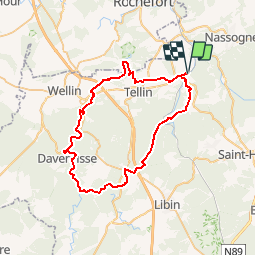
Randonnée V.T.T. de 52 km à découvrir à Wallonie, Luxembourg, Tellin. Cette randonnée est proposée par gpstracks.

Description

More information on GPStracks.nl : http://www.gpstracks.nl

Profil altimétrique

Points d'intérêt

Point d'intérêt Tellin - START - Photo
gpstracks
TELLIN 

Localisation

Pays :
Belgique
Région :
Wallonie
Département/Province :
Luxembourg
Commune :
Tellin
Localité :
Bure
Départ:(Dec)
Départ:(UTM)
663474 ; 5551891 (31U) N.

Commentaires

Veuillez vous connecter pour laisser un commentaire ou une note


Randonnées à proximité

Randonnée Marche Tellin - Tellin. Natura 2000, des sites qui valent le détour ! Lx 7 - Photo
Marche
GUIDE+

Marche

Moyen
(6)
Tellin, Wallonie, Luxembourg, Belgique
9,6 km | 11,9 km-effort
1h 30min
Oui
Randonnée Marche Saint-Hubert - Mirwart_Vieux Moulin de Mirwart_Alternative Forêt (SH29 bis) - Photo
Marche
GUIDE+

Marche

Difficile
(11)
Saint-Hubert, Wallonie, Luxembourg, Belgique
10,8 km | 14,2 km-effort
3h 4min
Oui
Randonnée Marche Tellin - RL-GG-13_Grupont_Poix-Saint-Hubert - Photo
Marche
PRO

Marche

Très difficile
(2)
Tellin, Wallonie, Luxembourg, Belgique
26 km | 34 km-effort
7h 23min
Non
Randonnée Marche Tellin - Balade à Grupont - Photo
Marche
GUIDE
Desrumaux

Marche

Facile
(1)
Tellin, Wallonie, Luxembourg, Belgique
8,4 km | 11,9 km-effort
2h 33min
Oui
Randonnée Marche Tellin - Bure - Promenade des chapelles - Photo
Marche
GUIDE+

Marche

Facile
(1)
Tellin, Wallonie, Luxembourg, Belgique
4,5 km | 5,9 km-effort
1h 15min
Oui
Randonnée Marche Tellin - Tellin - Promenade du trou des Lûtons - Photo
Marche
GUIDE+

Marche

Facile
(1)
Tellin, Wallonie, Luxembourg, Belgique
5,2 km | 6,1 km-effort
1h 21min
Oui
Randonnée A pied Tellin - Tellin - Promenade des étangs - Photo
A pied
GUIDE+

A pied

Moyen
(2)
Tellin, Wallonie, Luxembourg, Belgique
20 km | 27 km-effort
Inconnu
Oui
Randonnée Marche Tellin - Grupont - Promenade du bois de Machi - Photo
Marche
GUIDE+

Marche

Moyen
(1)
Tellin, Wallonie, Luxembourg, Belgique
8,6 km | 12,6 km-effort
2h 37min
Oui
Randonnée Marche Tellin - Bure - Promenade du Pont des Cloyes - Photo
Marche
GUIDE+

Marche

Moyen
(1)
Tellin, Wallonie, Luxembourg, Belgique
6,9 km | 9 km-effort
1h 59min
Oui


Fermer
Mes abonnements